Search This Blog

Tuesday, November 29, 2016

Balance Rock State Park(Berkshires)

Visited the Balance Rock State Park, part of the much larger Pittsfield State Forest just over the NY state border in the Berkshires of Massachusetts. To get here from North Street in Pittsfield, head east on Wahconah Street to Pecks Road, which becomes Balance Rock Road.  Continue on Balance Rock Road into Lanesborough, where you see the state park sign on your left.  A park road heads west for about half a mile to a large paring area.
The centerpiece of the park is a 30 x 15 foot, 165-ton limestone boulder balancing precariously upon a smaller section of bedrock. It is conveniently located right beside the parking lot, complete with picnic tables.
I didn't see another soul around today, as conditions were quite gloomy.
I took the blue marked Balance Rock Loop Trail, which heads through a dark, deep forest.
 Melting snow, foggy mist, and a steady rain made for very eerie hiking conditions.
 Unfortunately the rain picked up, nearly drenching me, even under the forest canopy.
Got back to the car, soaking wet, after about 2 miles RT.  Not sure on exact mileage because I did not bring the GPS, nor did I get as many photos as I would have liked because I didn't want to bring the camera out in the pouring rain.


Monday, November 28, 2016

East Greenbush Town Park

Kalli, Bella and I got out for a nice walk at the East Greenbush Town Park on a beautiful late November afternoon Monday.  A very light layer of ice on the dammed area of the North Branch Moordener Kill.
The falls at the dam.
 We really enjoyed the quiet stroll, as always, along the creek.
 Bella loves exploring the woods.
 My big girl!
Did a couple of loops through the park for a total of about 1 mile RT.

Tuesday, November 22, 2016

Evergreen Mtn, Pine Island Mtn, Packsaddle Mtn(Catskills)

Following the season's first big snowstorm, my buddy Jim and I were quite anxious to get in some hiking under true winter conditions.  We headed south into the Catskills to hike the Lexington Range from Spruceton Road in West Kill.  First goal was to head up 3360 foot Evergreen Mountain(which doesn't have enough prominence to count as its own separate peak).  This was all a bushwhack hike, meaning we had to be careful to stay off of public property by crossing over to the north side of the West Kill through about a foot of snow on Spruceton Road, elevation of about 1775 feet.  From there the climbing began.
 The snow depth increased as we gained elevation.
 Passing beautiful snow covered stone walls on the way up Evergreen Mountain.
 We gained nearly 1600 feet on the way up the mountain.  Hit some pockets of some deep, drifted snow making the ascent difficult at times.
 Winds were really whipping around, especially at higher elevations, leading to blowing snow and picturesque winter scenes.
 Nearing the top of Evergreen Mountain, which was covered in beech.
 Approaching the summit cone of Evergreen under clearing, cold skies.
 From a small rock ledge near the summit is a nice south view towards North Dome and Mount Sherrill.
 Sherrill and Balsalm Mountains towards Deep Notch(L-R).
 Looking directly south at a developing snow squall over the Burroughs Range through the deep cut between North Dome and St. Anne's Peak.
 Continuing west off Evergreen's peak, we began a steep descent down towards the col between Evergreen and Pine Island Mountain.  We managed to stumble upon a small ledge and viewpoint north towards Route 23A and the valley beyond.
 A shoulder of Pine Island Mountain directly west above the col.
 We dropped down to a touch below 2600 feet in the col and then climbed back up the steep slopes of Pine Island Mountain.  We skirted a band of rock ledges just below the summit.
 The wooded 3140 foot summit of Pine Island Mountain.
 Continuing past the summit with weary legs.
 A wintry scene on the west side of the ridge below Pine Island's summit.
 A look back at Pine Island Mountain on our ascent of Packsaddle.
 Trudging along through the deep snow as we near the summit of Packsaddle Mountain. 
 At the summit of 3100 foot Packsaddle Mountain. Unfortunately a bit smudged.
We dropped quite steeply off the southwest side of Packsaddle Mountain, eventually reemerging along Spruceton Road.  Luckily we found a bridge crossing over the West Kill, helping to keep our feet dry.  We were both thankful for that.
 We walked along Spruceton Road as the sunset and the temperatures continued to drop.  A stiff wind persisted as well making it quite uncomfortable.  I paused for a moment to capture this shot of a red barn and Sleeping Lion Mountain rising above.
Hiked about 9 miles with an elevation gain of 2700 feet total over 3 peaks.  Two more that count towards my goal of the 102 highest Catskill peaks, making it 56/102 total.

Thursday, November 17, 2016

Mount Fray(Southern Taconics)

Decided to hike 1893 foot Mount Fray and the northern section of the South Taconic Trail after work Thursday.  Mount Fray is much better known as Catamount Ski Area, which is located along the mountain's north slopes.  Finding the start of the trail can be a bit tricky, as there are no markers or signage.  Just east of the state line on Route 23 is a small pull off, with room for several cars, on the south side of the road.  Park here and walk about 150 feet east to a set of three small stone pillars.  Look for white paint blazing on the trees just past this.  That is the start of the trail.  The first .25 miles of the trail are confusing, but keep looking for the white blazing and you should be okay.  After emerging from a small patch of woods turn onto gravel Nicholson Road, and then another quick turn onto Jenssen Road(which appears more like a driveway).
 The trail follows the road for a couple of minutes before re-entering the woods again, only to repeat this one more time before finally arriving at the bottom of a ski slope.  Cross the ski slope in almost a straight line towards the woods and then look for the white blazing again. 
 Once in the woods, the climbing begins, quite steeply at first.
 The trail heads south and then swings west, passing through a northern hardwood forest.  Near the top of the first bump on Mount Fray's east side is a radio tower.
 Radio tower.
 Once near the radio tower, the foot trail becomes a woods road and is very easy to follow along the ridge line. 
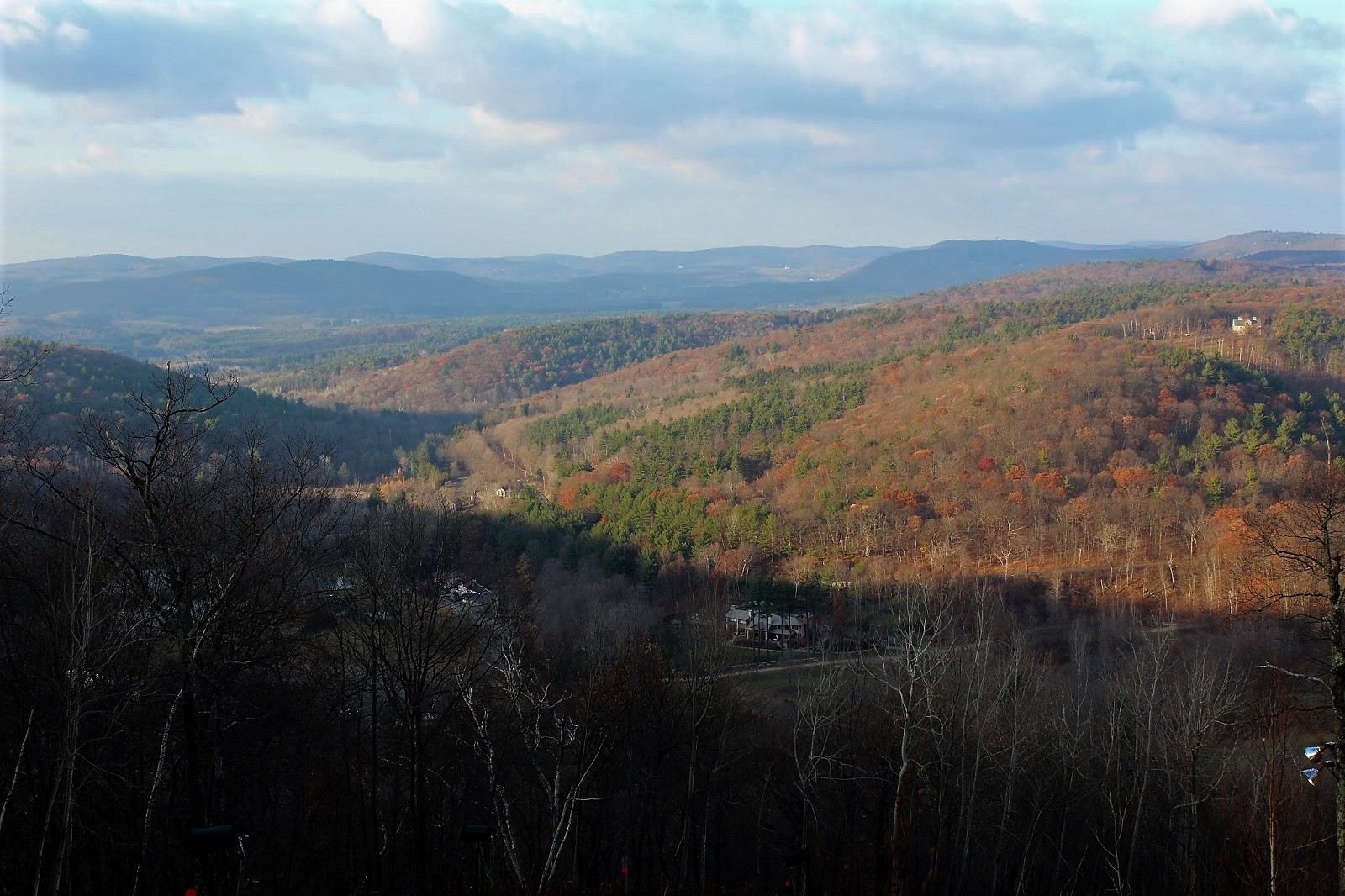
 Emerging at the top of a ski run, with the first unobstructed views of the day.  Here is a view northeast.
 Continuing west along the trail, which remains wide open along ski runs.
 Looking back to the east, where skies seemed to be clearing.
 Continuing to ascend.
 A north view beyond another ski slope.
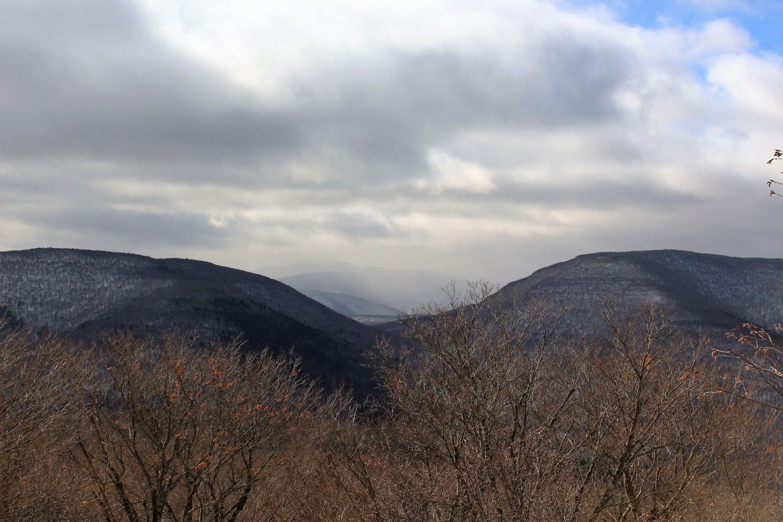
 As I neared the summit ridge, the clouds to the west seemed to be thickening up.
 A map of the ski area at the high point of Catamount.
 Just below the Catamount sign and gondola are the best views to be found.
 The broad, north facing views atop Catamount's ski slopes.
 Retracing my steps back a couple hundred yards, the trail leaves the ski slopes and enters the woods heading south(this turn can be hard to miss).  This stretch of trail has almost a tunnel like effect.
 Highly changeable skies above as I approached the summit.
 A small opening provides a nice view southwest.
 The South Taconic Trail comes close to, but does not go over the true summit of Mount Fray.  I continued south past the viewpoint to an area about .15 away from the summit.  This meant losing some elevation, but the woods appeared so wide open that it didn't seem so bad for bushwhacking.
Less than a couple hundred feet from the summit, the woods tightened up quite a bit with scrub oak, making it very challenging to gain any ground.
 The nondescript 1893 foot summit of Mount Fray.
 On my bushwhack back towards the trail, I happened upon an old state line boundary marker.
 Once back on the trail, the skies began to clear out, providing much different views north out over the ski slopes.
Northwest views towards Hillsdale.
Thought about hitching a ride on the gondola.
Ski slope view to the northeast and the Berkshires.
 Afternoon shadows creeping in on the north side of the mountain.
I made good time coming back down off the mountain, being careful for slippery, fallen leaves which cover the trail.  Scooting along the quiet, gravel roads on the way back to the car.
 Hiked about 4.5 miles RT with around 1000 feet elevation gain total.