Search This Blog

Thursday, June 10, 2021

Middle Mountain(Lake George Wild Forest-Adirondacks)

Headed north today on a refreshingly beautiful late spring day to do a little exploring in the Lake George Wild Forest around Jabe Pond and 1867 foot Middle Mountain to its west.  I chose to park at the beginning of the dirt access road to the pond(Elevation 1070 feet) and walk it, although it looks like it has been recently graded and smoothed out.  There are a couple of small steep spots so low clearance cars still may want to walk the one mile in.  In any case, it is a very quiet and pleasant road walk mid week.

Just about one mile south, the road comes to a large parking lot and information board about the pond.  From here, a trail drops down to the pond and then follows its north shore providing access to several small campsites.  Here is a view across the open water of Jabe Pond with Middle Mountain to the SW in the distance.

The trail around the pond was nice and easy to follow until it came to a cove and adjoining wetland on the west side of the pond.  I lost the trail here and had to circumvent my way around it, circling around to the spot I wanted to begin my bushwhack.  


Once I began my bushwhack, it was a pretty straighforward route west between a couple of small peaks, then towards Middle Mountain's east slopes.  At the foot of the peak I came across this pretty beaver pond.


Pink lady slipper well off trail.


The climb up Middle was fairly pleasant through mostly open woods and even a large area of fern glades near the top.

The area around the summit is surrounded by small cliff bands and sedge grass making for fun bushwhacking.  Although it is open, the true 1867 foot summit unfortunately offers up no views. 
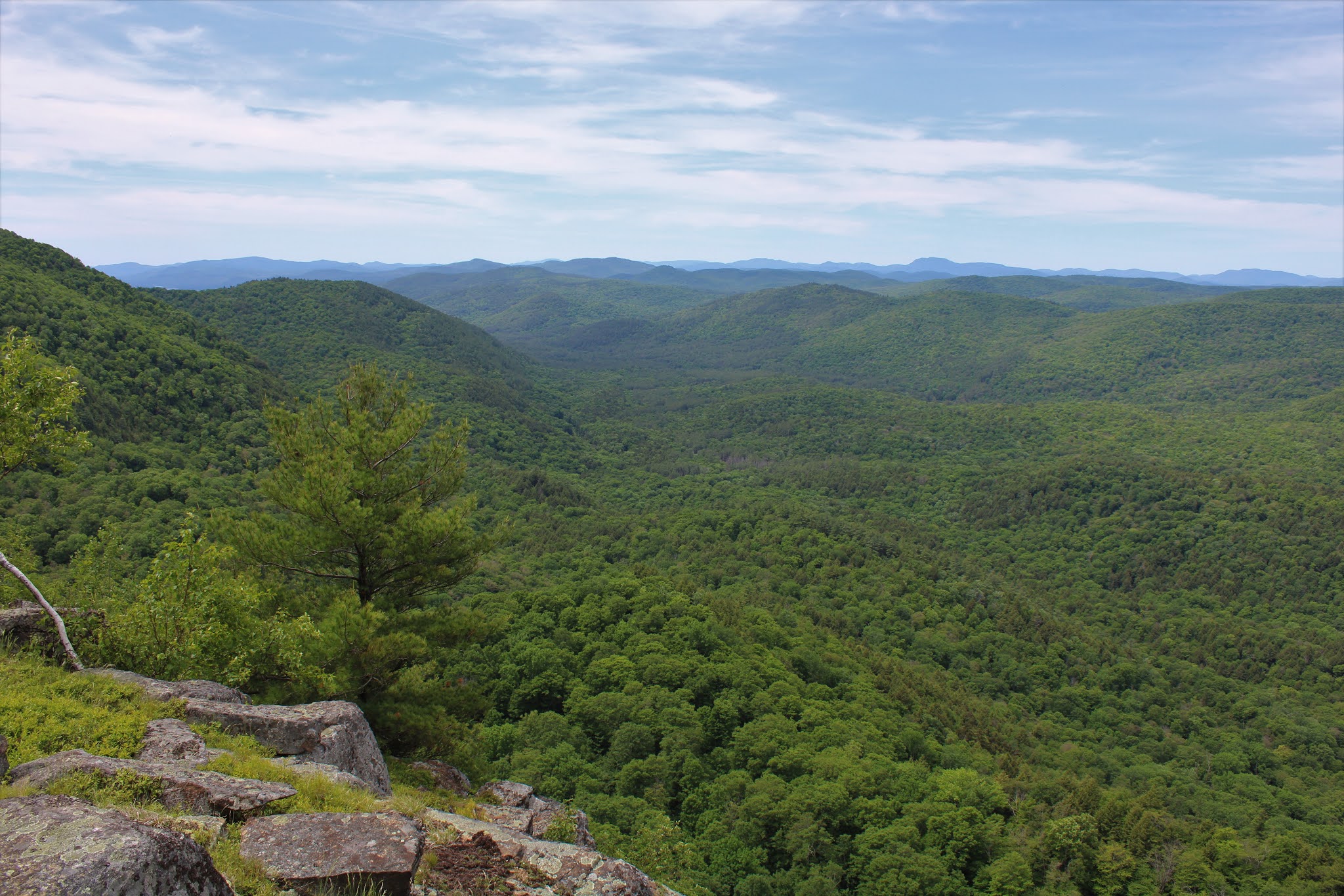
Just a short distance south off the summit are a series of small viewpoints to the west from extremely steep and nearly vertical ledges.  Although each view is nice, there is one open ledge on the SW slopes in particular that offers up tremendous views.  This is a look NW with Beech Mountain in the center from the open viewpoint.
From the open area, the view southwest over the Fly Brook valley is quite dramatic.

Circling around the ledges, I found an impressive view of Catamount Mountain to the south. 

Stellar views south towards Catamount, which almost looked close enough to touch!
I could've stayed here all day soaking in these views, but unfortunately the deerflies had other ideas.

After enjoying the amazing views, I headed back down the east side of the mountain and back over to Jabe Pond.  Instead of heading straight back to the car, I made one last pit stop to Little Jabe Pond, which sits just north of Jabe Pond.

From Little Jabe, I bushwhacked straight over to the dirt access road, which I then followed back to the car.  A very nice 6.8 miles RT with 1300 feet of combined ascent, and only saw one other couple out walking their dog early in the morning.

Blue X=Parking   Red X=Summit  Black X=Appx area of ledges


Wednesday, June 9, 2021

Hand Hollow Conservation Area(New Lebanon, Columbia County)

Once the storms moved through and the skies cleared out this evening, I headed over to the nearby Columbia Land Conservancy's  Hand Hollow Conservation Area to get a little walk in.  Although the humidity was still hanging in there, the conditions were improving by the minute, as I headed out from the trailhead on Gale Hill Road.  As always, the centerpiece of the property, Meizenger Lake was as beautiful as ever.


 I took the blue trail down to the lake, before hitting the green blazed trail, which meanders through the woods for about 1.5 miles, crossing here over a tributary of Hollow Brook on a rustic footbridge.

The green trail heads generally east, passing through deciduous woods and crossing over the remnants of old stone walls.


Another footbridge crossing over Hollow Brook, a bit further east.  Unfortunately, the deerflies were becoming a bit of a nuisance around this part.


I continued all the way over to the east parking area along County Route 9, where the trail emerges into open meadows and views over to the hills of neighboring Hand Hollow State Forest.


A nice and quiet return walk back on the same trails got me back to the car just prior to darkness setting in.  A very pleasant 3.5 miles RT and only saw one other person the whole time.


Friday, June 4, 2021

Mattison Hollow(Berlin State Forest-Taconics)

Turned out to be a beautiful evening so I decided to do a short trek on the Mattison Hollow Trail in one of the Taconic "Hollers".  The trail is found on dead end Mattison Hollow Road in the town of Berlin near the foot of the thickly forested western Taconic slopes.  I parked on the shoulder of the road beside the start of the trail(Elevation 1214 feet), where there is barely room for a car or two to squeeze off.

Stone walls are a staple of many of the mountains in the northeast, but the remnants here were white quartz, which is a bit unique to the Taconics.
The trail, blazed in yellow, heads generally east/northeast staying fairly level deep in the hollow, with steep slopes falling off to the north and rising straight up to the south.  Conditions on this early June evening were almost perfect.
The sounds of Kronk Brook, rushing far below the trail to your left, are audible for much of the trail, but it's not until about 1.4 miles in, that you are finally afforded an up close view of the stream.  Right at the corner of private land, a pretty flume on the brook can be seen, crashing down through a rocky drop.  This was commonly known as "Davis Cascade" to locals.
Just beyond the cascade, the trail comes to a small footbridge crossing of one of the branches of Kronk Brook. 


Once across the tiny footbridge, you will notice an overgrown clearing of sorts just to the left of the trail.  This marked the spot of an old, abandoned farm site, and is often referred to as "Collin's Lot".  Looking around, I was able to find old foundations and other remnants from the past.  Hard to imagine the tough life that a farmer must've had deep in this hollow.

With the hour getting late, I chose "Collin's Lot" to be my turnaround spot.  A nice and easy 1.5 mile hike return hike brought me back to the car, with daylight fleeting in the dark shadows of the hollow walls.

A very pleasant 3 mile hike, on a gorgeous late spring night.  Another wonderful place to enjoy the solitude of the woods.


Thursday, June 3, 2021

Schoharie Creek Preserve(Town of Charleston, Montgomery County)

Headed out to the Mohawk Hudson Land Conservancy's 198 acre Schoharie Creek Preserve this afternoon, with dark storm clouds in the air.  Got started from the parking lot off of Butler Road(Elevation 640 feet), which is located just north of the Schoharie County/ Montgomery County line in the town of Charlseton.  Followed the blue blazed trail down towards picturesque Wilsey Creek, where there are several pretty falls and cascades that sit just off trail down a steep embankment.

Slick rocks make for tricky footing, but the rushing water and misty air make for a great setting.
Staying high above Wilsey Creek, the trails soon crosses Butler Road heading generally east before dropping steeply down towards the Schoharie, aided by wooden steps in one particular section.
After the steep descent, you soon leave the woods behind and arrive on the west bank of the Schoharie Creek. From here, the trail hugs the shore for a short distance south before turning back into the woods and re-climbing back up to the parking area.
Completed the 1.3 mile blue marked loop, and barely beat the rain.  High humidity had me drenched in sweat as I arrived back at the car..and so it begins.  At least the bugs weren't an issue.

Cotton Hill-Long Path(Dutch Settlement State Forest, Schoharie County, NY)

With scattered storms in the area this morning, and even more, stronger storms forecast for the afternoon, I chose to do a small hike along the Long Path in the tranquil woods of rural Schoharie County.  My thought was to hike up and over Cotton Hill and see how far I could get on the LP before the weather turned me around.  I parked in the small pull off along Treadlemire Road(Elevation 2020 feet), where the recognizable aqua blazes of the Long Path head east into the woods. 

As many Catskill and Schohare County peaks, the wooded slopes of these mountains are laced with old stone walls.

Less than 1/3 of a mile into the hike, I arrived in the large clearing where the Lean To is located.  This is a great spot, and looks to be well maintained.

The Lean To is located just below the summit of Cotton Hill, and offers a screened view to the west, where storm clouds looked to be slowly moving in.
 Pine plantation atop Cotton Hill.
From the Long Path, a short spur trail leads several yards over to a small rock cairn which marks the 2114 foot summit of Cotton Hill.
The Cotton Hill summit survey, found right beside the rock cairn.

Beyond the summit, the trail soon begins to descend the east slopes of the peak, passing through a handsome mixed forest.  Bird songs fill the air, and the distinct feeling that you are far away from the rest of the world takes over in these quiet woods.

The quiet forest walk turns north for a short distance then continues east, before meeting up with an old woods road that drops sharply south down into a large, open meadow.

From the meadow, a good woods road continues south all the way down to Cotton Hill Road.  The woods road is actually driveable near the bottom, and makes for a very pleasant walk. 

With an uncertain forecast and cloudy skies, I chose to turn around at Cotton Hill Road, where a weathered old Long Path sign greeted me.  At this point, I had dropped over 600+ feet from the summit and now would have to re-gain all of that elevation I had lost.

From my turnaround point at Cotton Hill Road, I retraced my steps back up to the summit of Cotton Hill, which was really a nice and easy ascent.  Dark storm clouds rolling in kept me moving and rising humidity combined to work me up into a pretty good sweat, however.

Hiked just under 4 miles round trip, with 700 feet of ascent.  Didn't see another soul all day, and the impending rain held off.  If you are looking for a fairly remote trail with plenty of solitude, then this is the hike for you. 

Rough route below.   Blue P=Parking  Red=Trail   Blue X=Turnaround point


Tuesday, June 1, 2021

Carey Hill and Goose Pond Hill(Pharaoh Lake Wilderness-Adirondacks)

While Pharaoh Mountain and Pharaoh Lake garner most of the attention in the Pharaoh Wilderness (and deservedly so) as well as the abundant ponds scattered throughout, there are also a bunch of small little peaks tucked away that are hidden gems.  Today my game plan was to climb Carey Hill and Goose Pond Hill, a couple more small peaks that sit just off trail near Goose Pond in the northern section of the Pharaoh Wilderness, on what was forecast as a nice spring day.  I parked at the first parking area along Crane Pond Road(Elevation 980 feet) and set out, choosing to hike in on the road instead of driving it.  If you have a high clearance vehicle and really take your time, the drive in to Alder Pond is doable, but still rough.  The road walk is pleasant enough as it passes by a couple of small cascades on Alder Creek, slightly downhill off the road.

Just under a mile south from the parking area, the official trail to Goose Pond begins, with scenic Alder Pond only a few yards away.  This makes a very nice little spot to check out the beautiful views.

The trail between Alder Pond and Goose Pond passes through an enchanting hemlock forest for 6/10 of a mile before arriving at Goose Pond's north shore.  There are many nice spots to soak in the view towards Pharaoh Mountain, which rises impressively across the water to the SE.

I followed a well defined herd path west along the north shore of Goose Pond until I saw some unofficial red paint blazes which headed up into the col between Carey Hill and Goose Pond Hill.  Not sure exactly where these blazes are supposed to lead, but I followed them for a bit because they were going right where I wanted to go.  At one point I lost them so decided to bushwhack straight up Carey Hill's steep slopes.  The woods were very open and nearly 100 percent hardwoods down low, before finally hitting some more conifers up high.
Carey Hill has two summit bumps, but the first one I hit(the east summit) was the one with the open rock slab near the summit. 
Contouring around the south slopes just below the summit, there are some really nice views.  To the south Pharaoh Mountain can be seen(left) with Smith and Leeland Hill in the foreground(right).
The best view of all is from a ledge facing west towards Schroon Lake.

A zoom view of Schoon Lake.
Skies were highly changeable today, with bright sun shining one moment, and dark storm clouds right behind.  Luckily there was a nice breeze that helped keep the bugs down a bit, although they were still quite pesky.

Heading up to top of Carey Hill, with soft pine needles underfoot and conifers above.

The eastern summit is the higher peak and sits at 1680 feet, but is unfortunately wooded with no views.

I hit both of Carey's summits(west peak has no views) before heading back SE towards Goose Pond Hill.  In between peaks a light shower quickly moved through before being replaced once again with clearing skies.  Near Goose Pond Hill's summit, I dropped down to some  south facing ledges that offered up partial views.

I had a hard time finding much in the way of views atop Goose Pond Hill, although the 1582 foot summit was quite pleasant.  Just a few yards from the top there is a large rocky opening, but with no views.
A nice and easy descent northeast off the peak quickly brought me back down to Goose Pond, which I skirted around on towards its east shore.  One neat spot was a beaver dam crossing near the SE edge of the pond.

The east side of the pond is quite steep and rocky in spots but I made it back to another herd path easily, which I followed north all the way back to the yellow marked Goose Pond Trail.  From there it was an easy hike back to the car.  For such a popular area, I was shocked to only see two other people all day, which I saw on the trail early in the morning.  Hiked about 7 mile total, with nearly 1300 feet of total ascent.

Red=Summits  Blue=Open ledges