Search This Blog

Tuesday, June 27, 2017

Hand Hollow Conservation Area(New Lebanon)

After a day full of on again off again rain, the sun finally grabbed a stranglehold by late evening, leaving me with a very pleasant evening stroll at the Columbia Land Conservancy's Hand Hollow Conservation Area.  I parked along Gale Hill Road and took the blue marked trail directly down to Meizenger Lake, where the calm water and striking reflections made for a serene setting.
 Sometimes nature takes your breath away.
 I continued on to another clearing on the lake shore, with more fantastic reflections.
 I continued around the lake on the green marked trail, where I was soon bathed in full sunlight.
 The lake views from the far southeast side of the lake were just as enjoyable, as the sunlight streamed down onto the calm waters.  Fog and moisture can be seen rising off the lake, adding a nice twist.
Turned around by the dam, heading back the way I came.  Startled this deer along the way, but they cooperated long enough for me to get a picture.
A nice, quick stretch your legs walk, located only a few minutes from my house.  Round trip just over one mile.

Monday, June 26, 2017

Grafton Forest Lookout

On my way home from Vermont today I decided to pay a visit to the Rensselaer Plateau Alliance's brand new trail in the Grafton Forest.  The trailhead is found at the very end of Stuffle Street, which is a good road until the last mile, where it becomes very rough.  I took my time and was very careful and made it(even with my low clearance vehicle).
 The Valley View Trail follows a muddy woods road for a half mile on its way to the lookout.
 Arriving at the lookout spot.
 A couple of large rocks are found at the lookout, which provides an outstanding view north over the Tomhannock Reservoir.
 A storm began rolling in over the Reservoir.
 Heavy rain moving in over Bald Mountain's radio towers.
 The clouds began to creep across the valley right towards me.
 I noticed some updraft coming my way...and the winds began to really pick up.
 Too close for comfort!  I turned around and high tailed it back to the car after this shot, running with the strong winds and raindrops all around me.
Great views for little effort.  The hardest part of this hike is driving to the trailhead.

Mount Ellen/Cutts Peak(Vermont)

While New York has its 46 4,000 foot high peaks and New Hampshire has its own 48, Vermont has only 5.  These five peaks all offer incredible views and are fun to climb any time of the year.  My goal was to hike 4,083 foot Mount Ellen(tied for the 3rd highest in the state) from the Jerusalem Trail today.  This would be my fourth Vermont high peak, leaving only Mount Mansfield left to climb.
To access the Jerusalem Trail I took Route 7 north to New Haven, then turned east onto Route 17, following it all the way to Jerusalem Road in Starksboro.  Turn right onto Jerusalem Road and after .8 mile, turn left onto Jim Dwire Road.  The trailhead is located about a half mile on the right, with parking available on the shoulder of the road.  Elevation to start the hike is 1465 feet.
The Jerusalem Trail travels through private property so it is very important that you stay on the trail.  There are maple syrup lines that can be found throughout these woods and beside the trail.
The trail climbs about 1900 feet in 2.4 miles but is never especially steep.  It is pretty muddy however.
The last quarter mile push to the Long Trail is the most strenuous part of the Jerusalem Trail, and enters a deep spruce forest.
 Once on the Long Trail, I turned right(south) and quickly came to a small opening in the forest canopy, providing a glimpse at the ridge north.
 Continuing south, there are many peek a boos along the way, some good, some very good.
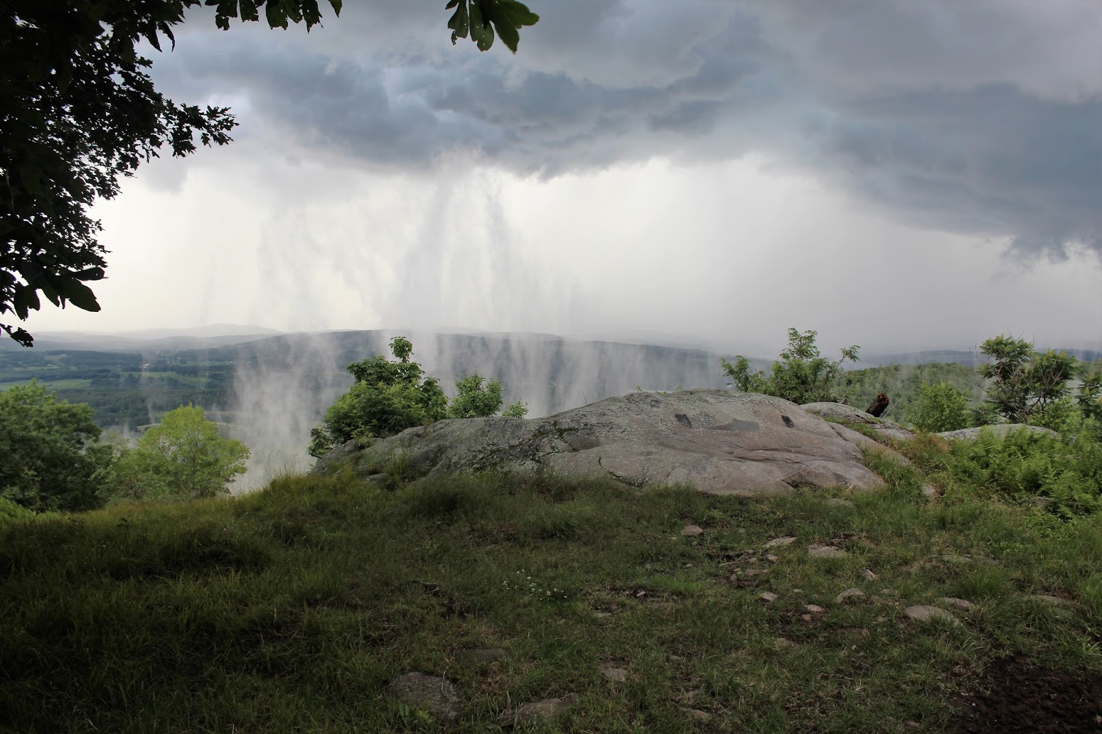
 I found this nice westward view just off trail along the way.
 Entering the Green Mountain National Forest.
 A rocky, steeper section on the way towards Mount Ellen.
 At a rocky clearing along the way, there are very good, open views towards the west.
Northwest views towards Lake Champlain.
Arriving at the very top of the ski run, just below the summit.
 After 1.8 miles south from the trail junction, and 4.2 miles from the car, I arrived at the 4083 foot summit of Mount Ellen.  Elevation gain is 2618 feet.
 I continued on a half mile south towards 4022 foot Cutts Peak, a sub summit of Mount Ellen, that doesn't have enough prominence to count as its own peak.  Here is a view of Cutts Peak summit bump ahead on the trail.
 After turning around just past the summit of Cutts Peak, I headed back towards Mount Ellen to enjoy the ski slope views to the east just below the summit.
 West views from the ski slopes.
 The north facing views towards General Stark Mountain and beyond.
 West views again.
East facing views down to the Sugarbush Ski Area and Central Vermont.
Headed back north on the Long Trail to the Jerusalem Trail and back to the car.  Mileage for the day was about 9.5 miles RT.

Wednesday, June 21, 2017

Thacher Park via Ryan Road

Celebrated the summer solstice by visiting the quiet, northern area of Thacher Park this afternoon.  Parked at the very end of Ryan Road, where a large parking area provides access to two trailheads.  I opted to start on the trail all way to the right of the lot on the yellow perimeter trail on a gorgeous, breezy, comfortable day.
 Almost all of the trails in this part of the park are level, but the trails near Ryan Road were especially muddy today.
 Wildflowers in bloom.
After a little over one third of a mile, I pricked up the Long Path and followed that northwest through a mostly hardwood forest.
After meeting up with the Hang Glider Road, I turned right, following this old road to Hang Glider Cliff.  An incredible, peaceful vista awaits.  The village of Altamont sits nestled amongst the green far below.
 Looking towards High Point.
 Distant views towards the Albany skyline.
 A nice, summer breeze and low humidity made this a prime spot to relax and soak in the sun.  I hung out here for about 15 minutes by myself.  A true sense of solitude here you can't experience in the southern part to the park.
After retreating back to the Long Path I turned right and headed towards High Point. At almost all intersections there is good signage and trail mileage.
The Long Path runs concurrent with the red blazed Fred Schroeder Trail north to High Point Cliff.
 High Point Cliff offers more sweeping views, but is a much smaller area than Hang Glider Cliff and footing can be tricky if you are following the informal paths along the ledges.  Here's a view directly down over the Altamont Fairgrounds.
 High Point Cliff is a very fun spot to explore and soak in the commanding vistas.
 Continued west along the Long Path with minimal elevation change on y way towards Old Stage Road.
 Just before arriving at Old stage Road, the Long Path passes by a very large, wide open meadow.
 At the next trail junction, I turned left onto the yellow Perimeter Trail heading towards Carrick Road.  I passed by this interesting tree along the way.
The Perimeter Trail passes the Carrick Road trailhead and continues generally east on an old extension of the road.  Eventually the trial becomes a smaller foot path again, soon arriving at a small, but picturesque pond.  This pond has clearly risen beyond its original banks crowding the trail and even rerouting it in one area.
Continued east on the Perimeter Trail all the way back to my car on Ryan Road.  Hiked about 6 miles RT on a picture perfect day.