Search This Blog

Monday, February 24, 2020

Black Rock Mountain(Black Rock Forest Consortium-Hudson Valley)

After an early morning bushwhack in the Catskills, I decided to head further south to the Black Rock Forest Consortium, an area I had never visited before, located just west of Storm King Mountain in the western Hudson Highlands.  The Black Rock Forest is a private 3870 acre forest and biological field station with over 30 miles of trails and roads open to the public for hiking.  With it already being early afternoon, I decided to dip my toes in the water and try a small hike up to 1402 foot Black Rock, the forest's namesake.  Got started from the parking area next to gated Pecks Road, located on the west side of Route 9w in Cornwall and headed out, starting at an elevation of only 400 feet.   The temperature had spiked to over 60 degrees by this point and it was really starting to feel like spring.
I wanted to make a loop hike of this peak, so I decided to first continue south along gravel Pecks Road, which closely follows pretty Black Hollow Brook for a distance. 
As I arrived at a Filtration Plant, the white blazed Black Rock Hollow Trail turns west, leaving the road and heading up into the woods on a footpath.
The trail steadily climbs up through the hollow, circling around Black Rock's steepest slopes to a junction with the Stillman Trail.  
Once on the Stillman Trail, the trail heads straight up towards the summit, with the woods above really beginning to open up. 
Emerging into the open summit area, the views are really quite nice.  Having climbed about 1000 feet from the car, it's easy to see why the valley views are so good! 
Wandering along the open rock, I found the great north view up the Hudson River.  A unique perspective of the river basin.
To the SW, many of the rolling summit bumps that make up the Black Rock Forest can be seen.
NW views spread all the way up to the distant Catskills.
After enjoying the spectacular summit views, I began my descent.  The initial drop off the summit is a fun little rock jumble.  Nothing too tough, but definitely fun.
I continued on the Stillman Trail until it met up with gravel Hulse Road, which drops all the way back down towards Peck Road and the beginning of the hike. 
A nice little introduction to a gorgeous area!  Hiked about 4 miles RT with over 1000 feet of ascent.  Looking forward to future visits to this beautiful forest.

Little Samuels Point(Slide Mountain Wilderness-Catskills)

Headed south to the Catskills to revisit "Little Samuels Point", the informal name of the small summit bump on the east ridge of Samuels Point on a very mild February day.  On my previous visit, my buddy Jim and I had approached this peak from Traver Hollow Road on the northern slopes, so today I decided to start from the east side at a small unmarked parking area where state land comes down to meet Route 28a.  Elevation to start was 750 feet just beyond a pair of old stone pillars.  I threw the spikes in my bag but figured I should be fine bare booting all day. The woods were remarkably wide open and easy to navigate as I slowly gained elevation heading west.  At about 1100 feet, I hit an impressive set of cliff bands that I had to go around...
...and from the top of the cliff bands I found the first views of the day, looking back NE towards Ticetonyk Mountain.
I continued up through just a few inches of softening snow, easily gaining elevation.
At about 1800 feet, I left the snow behind and caught my first glimpse of "Little Samuel" up above.
The last 2/10 of a mile were quite steep, pushing up through rock filled slopes.
As I approached 2100 feet, the west slopes really began to drop off, with very nice filtered views opening up. 
A large, solitary boulder marked the best viewpoint of the day.  From this vantage point, there are unimpeded views towards Wittenburg's SE ridge, as well as Balsam Cap and Friday beyond. 
To the SE, the view encompasses part of the Ashokan Reservoir, as well as South Mountain with  Ashokan High Point looming above.
The view west towards Wittenburg's SE ridge, which I had climbed a few weeks back(and also has very good views).
SE view towards South(foreground-left), AHP(distant left), Little Rocky(distant center) and Hanover(right).  The warm sun only enhanced the experience.
As I circled around the steep ledges, avoiding the mountain laurel above, I enjoyed through the trees views of 2885 foot Samuels Point.
I continued up to the open meadow atop the 2200 foot summit bump, complete with a rock fireplace.  A beautiful spot.
For the descent, I found a good woods road and followed that almost the entire way down, enjoying some filtered Reservoir views through the bare trees along the way.
Hiked about 3.8 miles RT with about 1500 feet of ascent.  A very nice little destination of its own.
Today's route      Red=Ascent      Blue=Descent

Friday, February 21, 2020

Brace Mountain(Southern Taconics)

This is the time of year when every minute is valuable for trying to do any after work hiking.  In making plans this afternoon, I figured I had enough time to head over to the southern Taconics and revisit Brace Mountain, a peak I had climbed before several years ago.  I parked at the small trailhead on Quarry Hill Road and set out under sunny skies.  I was happy to have the trail to myself, and with  cool, brisk conditions I got moving right away, trying to keep warm.  Elevation to start is roughly 940 feet.
The trail starts off quite casually, slowly gaining elevation before things get serious.  As the trail nears a waterfall(which was completely and impressively iced over today), the ascent becomes almost vertical in spots.
 Incredible ice formations on the falls.
Near the steepest section of trail, the ice got real tricky and I threw on the microspikes.  Even with the spikes, however, there were a couple of sketchy instances.
As I got beyond the worst of the steep, icy section of trail, things became noticeably easier.  Once I hit the white blazed South Taconic Trail, I decided to bushhwack over to an area of ledges on the west slopes of South Brace Mountain.  I found several open areas between 1900 and 2000 feet with good views, but one in particular was my personal favorite. 
 It wasn't so much a ledge, but a wide open grassy clearing with phenomenal views.
I continued my bushwhack north towards the saddle between South Brace and Brace before the terrain and thick mountain laurel forced me back up onto the trail.  Once back on the trail, I quickly emerged near the beginning of Brace's exceptional views.  This is a SE view into the Litchfield Hills of Connecticut, with theshoulder of South Brace to the right.
 The open trail high up on the summit ridge gives off the feeling of sky walking.
 Arriving at the breezy, wide open 2310 foot summit of Brace.
 North views up the Taconic ridge towards Alander.
Unfortunately the late afternoon sun didn't make for great photography, but the west views are still stunning.
 Northwest views stretching all the way towards the Catskills.
Wandered the summit area for a bit, enjoying the great views until the cold wind and late hour forced me to turn back.
 Heading back on the trail with South Brace looming ahead.
Between South Brace and the parent peak, there was several inches of crusty snow that was supportive enough to hold me.
Staying on the trail this time, I headed up and over South Brace and enjoyed the south views towards nearby Riga Lake.
Continuing down the ridge, the south view encompasses the Riga Lake in Connecticut(left), the Taconic Ridge(center) and Dutchess County in NY(right).
I picked up my pace a bit knowing that I had my icy descent ahead with darkness looming.  The valley below took on a much different appearance than my hike up, as the sun's late afternoon rays and early evening shadows began to take over.
Just before the steep descent, I paused here to throw on my microspikes once again and soak in this great view.  The descent was much worse than the ascent.  I really took my time in the couple of really tricky spots and made it just fine.  Arrived back at the car just as the sun set....like I said, every minute counts this time of year. 
Hiked just under 4 miles total with 1550 feet of ascent.  A fantastic little peak!!

Monday, February 17, 2020

North Point and Pitching Point(Storm King State Forest-West Hudson Highlands)

The Hudson Highlands are the spectacular peaks that rise directly above both sides of Hudson River, starting south in Peekskill in Westchester County up through Putnam County and over to Beacon in Dutchess County.  They are, to put it bluntly, breathtaking.  Along with that fame and notoriety, however, comes immense popularity, and finding solitude on any of these peaks is sometimes hard to do.  I set out Monday to hike a lesser used and known spot in the park, North Point, which sits just south of Storm King Mountain.  North Point is really just a north ridge of Crows Nest, the unassuming mountain that sits just south of Storm King. I parked in the unmarked parking area on Route 9W north(just south of the area called The Clove)and was shocked to see no other cars(even on President's Day!).  The Bobcat trail starts just beyond a vacant kiosk at an elevation of 1025 feet.  I set out on the white blazed trail under gorgeous late winter conditions.  This trail is quite rugged and rocky to start, dropping down to a small stream before soon coming to a trail junction at about 1/4 of a mile in.  This hike can be made into a loop, which many folks do clockwise....but with North Point and its open ridge just above me the other way, I impatiently headed counter clockwise following the blue blazes of the Howell Trail, emerging into open low bush fields within moments.
 
Not even five minutes into the hike, and I was enjoying these views of Butter Hill and Route 9W to the north.
 Incredibly, the views only get better!!  Almost immediately I was in awe. 
Passing over the wide open summit bump of North Point.  Views of Breakneck Ridge and Storm King were already teasing me, with the best still to come.
 The trail comes down to a very nice lookout spot, marked with an enormous boulder.  
The views are nothing shy of incredible..with the impressive cut of Route 218 into the side of Storm King Mountain and the rock face of Breakneck Ridge to the east.
After enjoying the awesome views, I continued on the trail, dropping a bit before a slight ascent up through peaceful hardwoods.
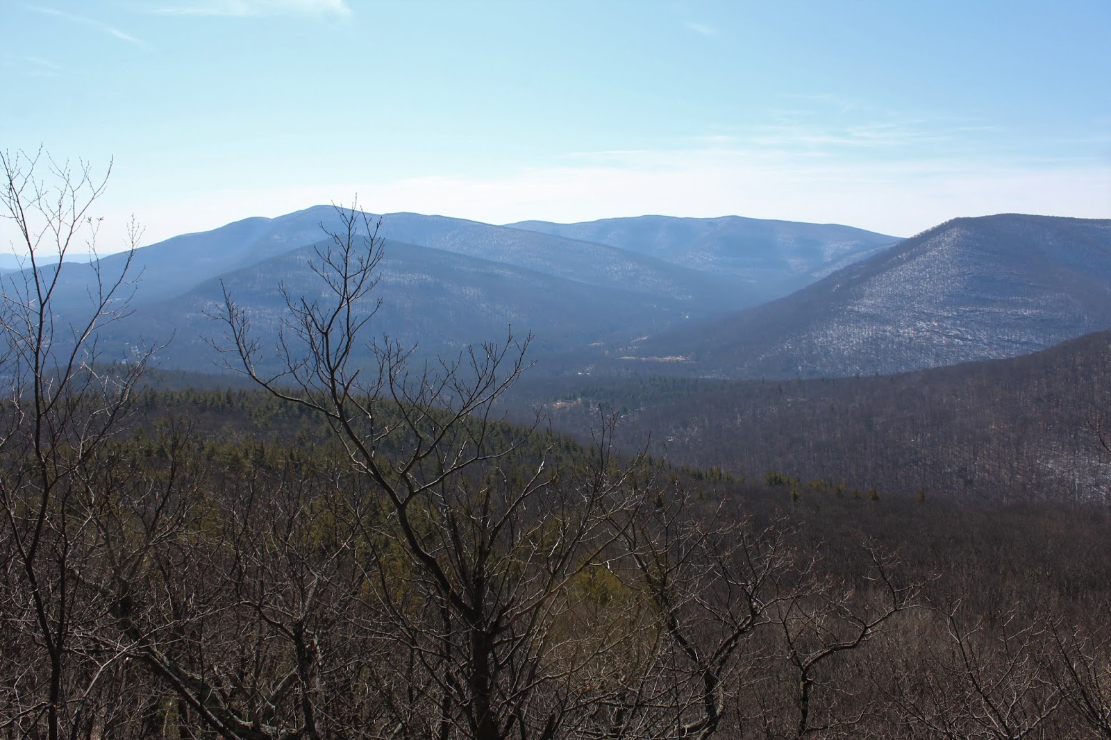
Within just a few minutes, the woods began to thin out again, and I hit more open view points.  These may have been even better than the first!!  The Hudson River basin spreads north towards the Newburgh-Beacon Bridge, with Storm King and Breakneck Ridge standing guard above. 
I wandered several open view spots, each with slightly different views north.  The small island visible is Pollepel Island, home of abandoned Bannerman's Castle.
From a little lower down on the ridge, from another clearing, I spotted this incredible view of the rock face of Breakneck Ridge.  Just to the north sits the smaller peak of Sugerloaf Mountain.
I found numerous spots with spectacular views and was able to enjoy each and every one of them by myself!  What a treat!
Continuing east, I dropped slightly down the ridge to Pitching Point, another wide open view point.  From here, the view across the river of Bull Hill(Mount Taurus) and its abandoned quarry is second to none.  What an amazing perspective!!
The village of Cold Spring sits at the southern foot of Bull Hill and can be seen sprawling out across the river from here.
 A south view downstream towards Constitution Island on the Hudson from Pitching Point.
As I continued on my way, the trail turns to the north, descending slowly at first..passing by more views and pitch pines.
A unique perspective of Butter Hill and Storm King Mountain, looking quite massive to the north.  There is so much open rock on these peaks!! 
I really thought this shot from just below Pitching Point was nice, because it not only gives a view of Route 9W below Butter Hill, but also the open area on North Point, which I had just been on before.
 
 Even as I dropped the views north were jaw dropping.  Simply stunning!
 More north views!
As I finally began the steep descent off Pitching Point, I hit the mountain's north shadows and also the day's first wintry conditions.  The most sheltered areas, just as this spot just off trail, seemed to hold the most ice.
 A window above the deep abyss that I was about to drop into. 
You could say the east slopes of the peak were steep...as evidenced by Route 218(closed for the winter), seen here, sitting about 500 feet straight down.
The trail utilizes many switchbacks to ease the very steep descent off the mountain down to Route 218.  I had dropped nearly 1000 feet to get this spot.  Storm King's rocky slopes can be seen rising above the road to the north.  From here, the white blazed Stillman Spring Trail heads west.
The ascent west was actually much less steep than I thought it would be.  The trail basically seems to follow old roads as it gradually gains back the elevation lost.  As I neared the the blue blazed Howell Trail again, the trail gets a bit rockier, turning more southerly.  Soon enough I was back on my old tracks, taking the Bobcat Trail back to the car. 
Hiked about 4 miles total with 1400 feet of ascent.  This hike was one of the more spectacular trail hikes that I have probably ever done.  The mileage was pretty short, but the views were outstanding...and one after another.  Simply put...wow!