Search This Blog

Sunday, June 29, 2014

The Dome(Vermont)

 Went for a very nice hike up to the Dome, a peak just north of the Vermont/ Massachusetts state line in southern Vermont.  Access to the trailhead is from Williamstown but the trail itself is located in the town of Pownal.   The trail starts at a small parking area near a tributary of Broad Brook and then briefly enters a wooded area before entering a large open field.
The trail basically follows old woods roads and is very rocky in many areas.
 A warm, sunny Sunday afternoon.  Nearly the entire walk is under a canopy of northern hardwoods.
 About 1.3 miles in and just after passing a junction with the Agawon Trail, you arrive at a giant boulder known as "Meetinghouse Rock".  This is a perfect place to take a seat and relax, and also marks the halfway point of the hike.
 The wide woods road slowly becomes more of a foot trail as it continues to climb. 
 At a major intersection there are muddy four wheel drive trails going in all directions, so you must carefully follow the red blazes and signage.
 A muddy section surrounded by ferns.
 The trail, while never steep, is a continuous climb the entire time.  Total elevation gain from beginning to end is 1720 feet, which is a bit surprising because of the lack of steepness.
 After a couple more wet areas, the trail enters a boreal forest area, a very rare site for this elevation and latitude. 
 This is a truly unique area and is much more likely to be found in northern New England.
 Red spruce and balsam fir dominate the summit area.
 The trail winds along the white rocky areas, called quartzite, to the rounded dome at the summit.

 Arriving at the summit of the Dome, elevation 2748 feet.
 Looking at the true summit, a large white rocky area, which makes a pleasant spot to relax.
 Lingered at the summit for about 20 minutes or so.  There was a true sense of solitude up here.  While there are no scenic vistas to be had, it is a very rewarding spot after a nice hike up.
 Pine cones everywhere.
 Looking through the trees down towards the Greylock Range.
 Views are impeded by the surrounding trees but it is still a magical spot. 
 Surrounding forest at the summit.
 Beginning the descent along the white rocks that make up this section of trail.
 Looking back at the summit of the Dome.
 Descending further though the boreal forest.

 
 Hardwoods quickly begin to dominate the forest again, once you leave the summit area.
 The hike was a very nice 5.2 mile RT with a consistent ascent and descent.  Stopped by the nearby Broad Brook Trail which follows the banks of the stream and eventually meets up with the Appalachian Trail.
 Pristine Broad Brook.
 Only walked up the trail for a short distance, admiring the picturesque brook.

Friday, June 27, 2014

Vroman's Nose

 My very old friend Art just moved back home after living in North Carolina the past 12 years and told me this week that he wants to start hiking with me.  Keeping in mind that he has never hiked before, I decided to take him to a short hike with incredible views.  Vroman's Nose is a local treasure loacted in rural Schoharie County.  Most of the climb is steady but never steep.
The trail is only about .7 miles to the top and even before that there are some amazing far reaching views.
 Art was feeling a bit winded but did a great job.  The final push to the top.
 This is truly one of those places that pictures do not do justice for.  The views from the open cliffs are spectacular.
 Only a few feet away from the trail is a very dangerous cliff.  Anyone with young children should definitely keep a watchful eye.
 Those tiny specs are cars in the fields far below.
 Art collecting his thoughts.
 An amazing spot to soak in the views.

 Great job buddy!
 Panorama.
 VERY steep.
 A shot to give some perspective on the sheer drop offs.
 Route 30 and traffic seen several hundred feet below.
 Looking back to the north and east on a gorgeous late June day.
 There were many others out soaking up the beautiful weather on top of Vroman's Nose.  It's hard to find a hike that is so rewarding for so little work.
 Looking back at the rocky cliffs.
Overall hiked about 1.5 miles total.  We really took our time.  I think Art did well, and I look forward to taking him again.

Thursday, June 26, 2014

The Snow Hole(Taconic Crest Trail)

Went out for a nice day hike to The Snow Hole, a large crevasse where snow can be found well into summer and located in the Taconic Mountains near the Vermont/ Mass/ NY state lines.
There is a large parking area at Petersburg Pass on Route 2 and the trail begins across the road going north from there.   The trail is actually part of the much longer 35 mile Taconic Crest Trail, but today we'd only be dong a section of that.  The initial .2 miles may be the toughest part of this hike as it climbs steadily uphill from the road.
 Once arriving at a trail register box, you already have some views back towards Mount Raimer and Petersburg Pass.
 A small side path just up the trail provides gorgeous westerly views out over the Petersburg valley.  Before you've even had time to break a sweat you've already had much to see! 
 Continuing along the trail, which was very muddy and wet from last night's soaking rain storms.
 Signage along much of the TCT is very good.  They are also very serious about no ATV's/ dirtbikes, etc.
There were actually parts of the trail that were much more like a small stream as water flowed swiftly downhill.
 Much of the trail is through a northern hardwood forest but after about 1.8 miles you come to a large cleared meadow area.
 The skies really began to clear about this time and the day turned out to be quite comfortable.  The open meadows were a welcome change to the deep woods walking.
 Another muddy section.
 After about 2.25 miles, you will see the first of what turns out to be three lookouts with amazing west views.
Each separate view point(which are only spaced about 200 yards apart) gets better as you go.
 This area is known as White Rocks and provides great views.
 A panoramic view to the west.

 Looking down into Petersburg with Route 2 clearly visible.
 Route 2 can be seen winding its way up the mountain and to the parking area at the Pass.
 Rolling peaks and blue skies.
 Route 2 and Taconic farmland.
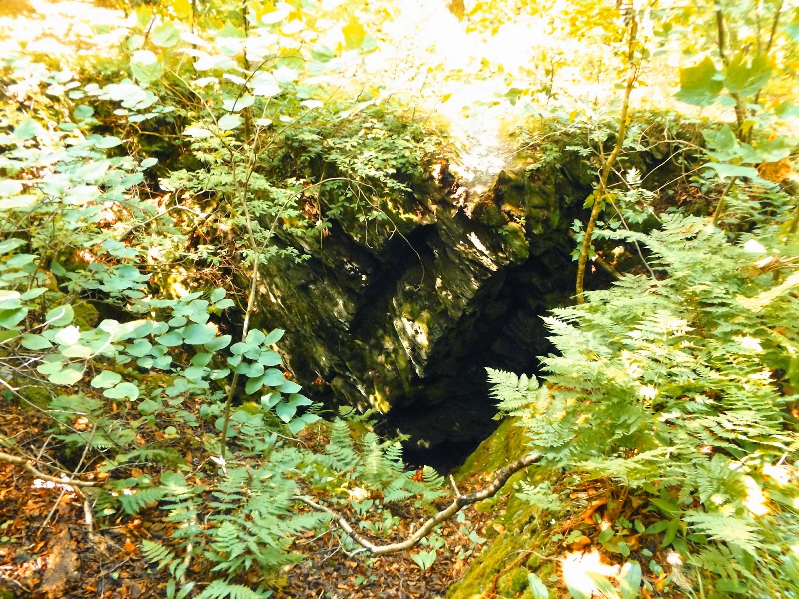
 After about 2.6 miles we arrived at the sign for the Snow Hole!
 A spur trail which makes a loop brought us down to this rare, and intriguing geophysical treasure. It is essentially a 50 foot deep cave in a depression that holds snow and ice well into the warmer months of the year due to its location.
At first glance it doesn't appear to be anything to be overly excited about.  Just a large crevasse in the ground.
 Once you make your way down into the actual Snow Hole, you realize why this is such an amazing spot.  It is a very deep climb down.
 The sudden drop in temperature as you descend is quite alarming.  It was about 75-80 degrees at the top and probably 20 degrees colder at the bottom.  Here is Holden standing at the bottom.  Notice how large the crevasse actually is.
 After digging around and moving some leaves we found a spot holding snow!!! 
 Looking out from the top of the Snow Hole.
 Holden is totally fascinated by this and wants to hang out.
 Looking waaaaay down at Holden from the top of the Snow Hole.
 We decided to continue on heading towards an east lookout into Vermont.  Found this little guy along the trail.  Seemed friendly enough.
 Some nice views down towards Pownal, Vermont.  Unfortunately the foliage made it hard to really get a nice vista.
 Pownal, Vermont and the Green Mountains.
 Continuing a bit further north, we started to get some screened views back to the west towards Prosser Hollow.  We eventually decided to turn around after going about 3.4 miles.
 The hike back was very pleasant, although the muddy sections and deep tire grooves made it a bit annoying.  We passed the only other hikers we saw the whole day, a family on its way to the Snow Hole on our return.
Overall hiked about 6.7 or so miles.  A very nice day hike with my nephew.