Search This Blog

Friday, September 27, 2019

Cedar Mountain(Southern Taconics-Columbia County)

Took advantage of yet another gorgeous fall day by doing a post work hike up the slopes of 1880 foot Cedar Mountain in the Southern Taconics.  While the summit is located just across the state border in Massachusetts on private land, most of the western slopes of the peak are accessible via the Taconic State Park in Copake Falls along Route 344.  I parked in the large parking lot for Bash Bish Falls, and then crossed the road to pick up the Cedar Brook Trail on the north side of 344.  After a couple hundred yards I quickly left the trail and began my bushwhack up the steep slopes of Cedar Mountain.  Elevation to start was 732 feet.
After some steep climbing, I stumbled across a small fire pit located in a hemlock grove. Kind of seemed like an odd place to set one up, but it wasn't that far from the trail(or road) so wasn't all that shocking. 
The dark softwoods soon gave way to open hardwoods, with some fall colors mixed in, especially in the underbrush. 
The foliage is coming along quite nicely in spots and made for very pleasant conditions.
As I quickly gained elevation on the steep slopes, I circled around to a small set of ledges at about 1450 feet on the NW slopes, offering up some very nice framed views of the Catskills and Columbia County farmland. 
I found the hiking to be very nice, with a lot of oak trees and sedge grass.
As I slowly made my way around to the south, I enjoyed many filtered views SW towards nearby Washburn Mountain. 
There were a couple of good clearings with unobstructed views to the south and west, with Washburn(L) and the Copake countryside to the right.
I hugged the south slopes of the peak, where the terrain was the steepest, in hopes of finding some cliffs.  As I climbed up and over 1750 feet, I found the beginnings of an impressive set of cliffs.
I climbed up to the top of the cliffs and then tried to make my way down to the ledges, but they were guarded by some gnarly mountain laurel, so the going was tough.  I pushed my way down to several open ledges, where the views were almost a full 180 degrees. Absolutely spectacular! West facing views towards Copake Falls.
The jaw dropping view of the day goes to the view down into the Bash Bish Falls gorge!  Wow!! 
A neat look at the ledges from a spot just below them.  These were tough spots to get to, with a vertical drop off only a few short feet away.
After enjoying the cliffs and ledges that literally go right up to the state line, I finally turned back, heading back down a slightly different route.  For the descent, I tried to hug the steep southern ledges further down the mountain and find some more views.  At about 1600 feet I lucked out, pushing my way through a thick stand of mountain laurel to a small clearing and viewpoint to the south to the deep saddle between Bash Bish Mountain(L) and Washburn Mountain(R).
From the same vantage point but looking due south, Bash Bish Mountain rises steeply above the Bash Bish gorge.
Enjoying one more nice view to the SW into southern Columbia County.
 
I took my time descending the steep slopes, enjoying what the mountain had to offer.  A very enjoyable off trail adventure on a picture perfect early fall afternoon.  3 miles RT with 1200 feet of ascent. Unfortunately the summit sits just beyond public land, so I didn't hit the top.
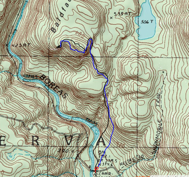
My route below. 
Black=Ascent   Blue=Descent  Red=parking

Wednesday, September 25, 2019

Baldface Mountain(Vanderwhacker Mountain Wild Forest-Adirondacks)

After hitting Venison Mountain, I headed a short distance further along Northwoods Club Road and parked at another small pull off, just before the bridge over the Boreas River.  This would be my starting point for 2057 foot Baldface Mountain, yet another trail-less peak in the Vanderwhacker Mountain Wild Forest.  Elevation to start was roughly 1240 feet and the view of the Boreas River from the bridge was worth the price of admission alone.
From the bridge, I headed north past a campsite, following the east bank of the river for a ways, enjoying the river sounds and views along the way.
After a short distance, the terrain basically forces you up, so that's what I did, heading steeply up and away from the river.  I saw several herd and game paths that seemed to meander all over the steep slopes, but I stayed the course, heading NW, crossing over a couple of small drainages.
To get to Baldface, you must first head up and over an eastern shoulder of the peak, which offers some decent views from a set of very steep cliffs.  The summit ridge can be seen here, to the right.
 South facing views across the deep Boreas River cut below.
Once atop the eastern shoulder, I cheated NW to stay away from an enormous set of cliff bands that cannot be climbed.  Basically the eastern side of the summit is a vertical wall of rock, so I continued north until the slopes gradually came down.  From there it was a short and easy ascent to the wooded summit(pictured below).
I had read about there being views on the SW side of the summit on other trip reports, so I pushed my way through some scratchy spruce and sure enough, I hit an impressive area of open rock slab, covered with spotty moss and a few trees.  The views up the Boreas River valley to the SE were exceptional and well worth the effort!
 Moss covered rock slab.
After enjoying the views, I began to head back, but insted of retracing my steps, I decided to check out the ledges on the east side of the summit.  I found several filtered views, but one wide open vista to the SE that was quite nice.  Although looking in the same general direction, this vantage point was about 150 feet lower than the other view spot and further east, giving it a unique perspective. 
From the eastern view, I headed back off the mountain, carefully retracing my steps around the ledges, eventually making my way back to the car.  A delightful 4.3 miles RT, with 875 feet of ascent.
My route to Baldface is below.
Red=Park   Black=Ascent   Blue=Descent 
It was still only mid afternoon, so I drove towards the end of Northwoods Club Road to check out the colors on Huntley Pond.  I was quite surprised to have the place to myself, as I had for the entire rest of the day.  One of the greatest perks to hiking on weekdays! 
 I enjoyed the solitude on the pond for a little while, before finally heading home.  A great day in the Adirondacks.

Venison Mountain(Vanderwhacker Mountain Wild Forest-Adirondacks)

Headed north to check out some foliage and do a pair of peaks in the Hudson Gorge Wilderness on what was forecast to be a gorgeous early fall day.  My first stop would be a short bushwhack from Northwoods Club Road to 2312 foot Venison Mountain.  I parked in a small pull off along the east side of the road then promptly headed east, quickly dropping to a crossing of Bullhead Pond Brook. An easy rock hop got me across and I was on my way.
The slopes of the mountain are a mixed forest, but mostly very open and easy navigation.  After a steeper push above some small cliff bands, I emerged into a tranquil park like setting of sedge grass and fern glades.
Once above the cliff bands, I began to find some decent views to the west, nicely framed by the foliage.
 Window views to the SW.
 Just below the summit, the woods give way to a wide open meadow and rock slab.
From atop the rock slab(which is not the summit), the views are very good into the surrounding Hudson Gorge Wilderness. 
 South facing views towards nearby Dutton Mountain.
After tagging the true summit, which was fully wooded in spruce, I headed back down the west slopes of the peak, enjoying my stroll through the ferns. 
A nice and easy descent got me back to the car in no time.  A great warm up on a nearly perfect morning.  1.5 miles RT, with over 650 feet of ascent.
My route below.
Black=Ascent   Blue=Descent

Saturday, September 21, 2019

Shanty Cliffs(Siamese Ponds Wilderness-Adirondacks)

With fall foliage beginning to creep in around home, I figured the colors up north would be a bit further along.  Boy was I right!  As I arrived in the East Branch Valley of Route 8 in the Adirondacks, I was stunned by the vivid fall colors.  If anything, the colors were further along than I could've imagined!  This was an after work hike so with limited time, I chose to do a short excursion up to Shanty Cliffs and then maybe do some exploring along the ridge.
I parked at the trailhead for Cod Pond, where a large pull off can be found on the south side of Route 8.  Elevation to start was a little bit over 1300 feet, meaning it would be a 700 foot climb up to Shanty Cliffs.  I crossed Route 8 and followed it north for about 1/10 of a mile, crossing over Stewart Creek, with views NW towards the Blue Hills.
 At the end of the guardrail over Stewart Creek, I turned left, following a rough road down towards a campsite on the East Branch of the Sacandaga River.
Once at the campsite, a faint herd path heads down to the East Branch.  This is where things have the potential to get dicey, because a ford of the river is necessary to continue up to the cliffs.  Luckily, water levels are pretty low meaning an easy crossing. 
The deepest the water got where I crossed was not even shin deep.  With temps in the upper 70's, it actually felt nice.
Once across the East Branch, I picked up a very good herd path, which is used by rock climbers to access the impressive cliffs.
The herd path actually continues up through a cleft all the way up to the summit, which sits a little over 2000 feet in elevation, but feels like you're on top of the world.  The views from here are absolutely breathtaking. 
 The fall colors on the East Branch were spectacular.  The reds, especially, were quite brilliant!
I explored the entire ridge, which actually consists of three separate high spots.  The herd path ends at the first set of ledges, but I bushwhacked the rest.  All three offer great views.  From the second and third high knobs, the views towards neighboring Blue Hills are incredible.  On this day, the Blue Hills would've been more appropriately been named the Red Hills.
 Stunning early fall colors provided many heart stopping views.
From the last clearing on the north knob of the three peaks, I found one more up close view of Blue Hills.
 SW views towards Corner, Moose and Georgia Mountains.
 A large rocky perch made a fun spot to enjoy the scenery.
 I could've taken pictures for days...the conditions couldn't have been more perfect.
 A look back up at the cliffs that make up Shanty Cliffs.
A nice and easy bushwhack brought me back to the herd path, which I followed back to the East Branch crossing and eventually the car.  A very nice 3 mile RT, with a lot of bang for the buck.  1100 feet of total ascent for the day.