Search This Blog

Thursday, January 30, 2014

Bromley Mountain

Had the day off and the forecast called for clear blue skies with temps in the 20's so I took full advantage and drove north to Bromley Mountain in Vermont.  The trail I'd be hiking today was a section of the Long Trail/ Applachian Trail. The two coexist as one through southern Vt before the Long Trail continues its path north to Canada as the Appalachian Trail winds east towards Maine.  Signage is very good along the AT/ LT with white blazes marking the AT for its entire length.
Even though there was anywhere between 6-15 inches of snow on the mountain, the trail was beaten down pretty good, so I left the snowshoes in the car.
Someone got creative in the snow.
There are several small stream crossings as well as a beautiful foot bridge over Bromley Brook. Bromley Brook was completely frozen over on this day but here is one of the streams meandering through the woods.
After 2 miles of moderate climbing there is a trail junction with several signs.  This is looking back south towards where I had just come from.
The summit of the mountain lies only one mile ahead.  Just right of this sign and about 500 yards away is the Bromley Shelter(Lean To).
The last mile got significantly steeper, but views to the southwest began opening up through the trees.
Nearing the summit, the trail comes across more spruce trees.
About 2.5 miles up the trail, a short spur trail leads to a vista to the southeast.
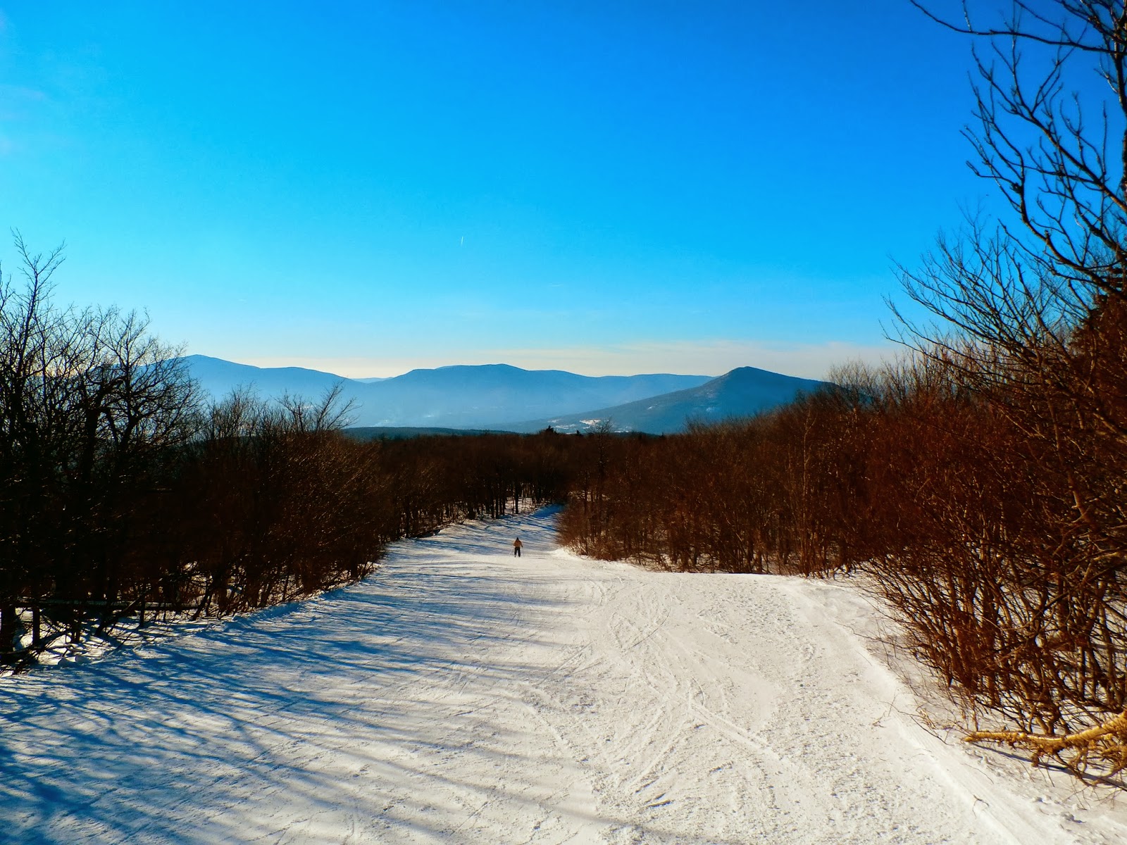
A short distance later the trail emerges from the woods and follows one of the ski trails from Bromley all the way to the summit.  The last .3 of a mile was very steep and several skiers passed me on their way down.
Once clear of the canopy of trees, the views down from the ski trail were simply amazing.
The Long Trail continues north from Bromley's summit here and descends rapidly towards Mad Tom Notch.
360 degree views from the summit offer a great view east towards Okemo Mountain.
From Bromley's summit, there are spectacular views of Stratton Mountain to the south.  The ski slopes of Stratton are clearly visible.
It is a truly different experience to hike 3 miles through deep woods, only to emerge at the top of mountain to a gondola and skiers all around you.
Bromley Mountain's summit area is unique due to it being an operational ski resort.
Views to the north stretch for miles all the way to the distant Presidential Range.
Tremendous views abound from the 3263 foot summit of Bromley of the surrounding mountains and gondola
Heading back down from the summit behind a skier with remarkable views of the Green Mountains.
Breathtaking views
Outstanding views accompany your hike back down the ski slopes to the woods.
As I hiked back down, a couple of skiers raced by  down the slopes.
One last look at the southwest views all the way to Mount Equinox.
Bromley Shelter is a very well kept, newer lean to that was built in 2003 with a number of tent platforms and a large outhouse.
The sun was beginning its slow descent as I hiked back down the AT/ LT.
As I arrived back at the large parking lot, I was greeted by the brightly shining setting sun and only one other car left.
A great hike totaling 6 miles RT on a beautiful winter day.

Wednesday, January 29, 2014

Harvey Mountain

With some free time and the sun shining bright on a cold, crisp afternoon I headed east to the Taconics to hike a little known treasure, Harvey Mountain in Austerlitz.
There are several different trail options for hiking the mountain, but due to time restraints, I drove the access road to the gate and hiked the 1.5 mile RT from there.  The access road provides tremendous views of the mountain's profile looking east.
 A northeast view from this clear cut area provides views into West Stockbridge and West Stockbridge Mountain.
 It is such an unknown gem that I was the first to set foot on the trail since the snow has fallen, with only coyote tracks and a few other animals breaking the pure white trail.
 There are hundreds of birch trees near the clearing just below Harvey's summit.
 This trail is actually another rough access road that climbs all the way to the summit area.  Here is the last steep climb to the large clearing area.
 Looking back down the rough access road, views into southern Columbia County begin to emerge.
 Filled with blueberries in the summer time, this is a huge clearing at the end of the trail.  While it isn't the true summit of the mountain, it is a remarkable place to see and enjoy.
It is such a unique summit because of the large meadow like area.
Great views to the north and west.
Looking up the hill in the meadow towards the true summit and state line.
No matter where you go it is hard to find a spot without a great view.
Unbeatable views.
Rolling hills of Columbia County.
Crystal clear blue skies and a bright sun make for a great, cold day.
Southern Taconics.
The late afternoon sun as it begins to slowly set.
An old stone wall sits buried beneath about 6 inches of snow,
Descending the trail back to the car.
 New York State Trail markers.
 Here is a view back at where I parked and hiked from.  This is the start of the trail that leads to the Pinnacle Point Lean To.
 Here is the access road off of East Hill Road.  A large parking area and New York State Forest signs are found here, as this is one of the official trailheads for Harvey Mountain.

Friday, January 24, 2014

Keleher Preserve(Wolf Hill)

Keleher Preserve on Wolf Hill, a 287 acre property owned by the Hudson-Mohawk Land Conservancy, sits high along the Helderburg Escarpment near the town border of New Scotland and Berne, about 20 minutes west of Albany. A fairly new preserve, the land was gifted to the Conservancy in 2010 and trails were completed by 2012, making this new preserve also one of the most popular for the Conservancy.
Another bitterly cold day outside but with the sun shining bright, I was more than happy to bundle up and get fresh air.
A rope is strung along up a steep slope to help make it easier for hikers.
Old stone walls can be found throughout the property, and several old farm roads are found at the preserve as well.
The blue trail loops through a hemlock forest before dropping down and along the escarpment with screened views of the valley below.
Much of Albany County can be seen from along this steep section of the trail.
This is the view pretty much the length of the blue trail along the escarpment through the trees.(it appears that a junkyard is visible through the trees as well)
Just off the trail is an extremely sharp drop off.
Route 85 can be seen far below where it meets with Route 443 at a Stewart's.
A red trail breaks off from the blue trail to a steeper section and back into an evergreen shaded area.
From the clearing at the end of the red trail can be found the best views all the way past the Albany skyline and to the hills of Rensselaer County.  With an elevation of 1636 feet, Wolf Hill is part of the ridge that separates the Onesquethaw and Hannacroix watersheds and has steep slopes on each side of the hill.
  Downtown Albany from the escarpment.
Came across a large meadow area as the trail climbs back up.  I believe this area may have been logged at one time in the not so distant past.
There were plenty of animal tracks in the snow throughout the preserve, but I was the first person here since the snow had fallen.  Hiked the entire preserve for a total of a little over 2 miles.
Much of this area is very rural as evidenced by this John Deere and farmland along Cass Hill Road.
Wolf Hill as seen from the bottom of Cass Hill Road in Clarksville.