Search This Blog

Monday, March 23, 2020

Hand Hollow Conservation Area(New Lebanon, Columbia County)

Headed out for an easy walk this morning at Hand Hollow Conservation Area in New Lebanon, owned and managed by the Columbia Land Conservancy.  As I headed out, light snow squalls were passing through covering parts of the ground in a coating of white.  Parked at the trailhead on Gale Hill Road(no other cars there when I arrived) and headed down towards Meizenger Pond on the blue trail.  A short spur path brings you down to a kayak launch spot.  A stiff, cold breeze blowing across the open water said today wouldn't be a good day to be out there!
Followed the blue trail around the west shore of the pond, pausing in a small clearing by the water's edge to soak in the view.
The blue trail soon meets up with the green trail, which is the main trail through the conservation area.  As I made my way around the south end of the pond, the quiet breeze and light crunching of snow underfoot were the only noises I could hear.
The trail winds it way around towards the dammed east edge of the pond, where I captured this nice look across the water.
The green trail meanders its way east, dropping down to one of two handsome footbridges that cross Hand Hollow Brook.
 Hand Hollow Brook dropping down through dark shaded conifers and a coating of white.
The trail weaves its way through mostly hardwoods, with the sounds of rushing water never too far away.  As I descended a small rise, I came across the remnants of an old stage coach crossing on the brook. 
The trail hugs Hand Hollow Brook for a spell before heading towards a clearing on the east end of the property.
Just beyond a junction with the yellow marked trail, I passed by a couple of sprawling beaver ponds and wetlands.  The beaver ponds through this section appear to be a bit out of their normal banks.
At the very far edge of the conservation area near the County Route 9(New Britain Road) parking area, what once was a beaver pond filled with water is now just a dried up muddy pit.
Turned around at the parking area and retraced my steps back west on the green trail.  Took my time returning through the quiet woods passing over old stone walls along the way.
Hiked about 3.8 miles RT and didn't see another soul all day.  A peaceful retreat on a cool early spring day.

Saturday, March 21, 2020

Guilder Pond & Mount Everett's East Ridge(Southern Taconics)

After visiting a small summit bump on Mount Everett's west ridge recently, I wanted to go back to check out another small summit bump, this one on the east ridge.   A sunny but cool early spring day of exploring would be a nice, albeit temporary, escape from the uncertainty out in the real world.  Parked at the gated entrance on the Mount Everett access road and headed out, elevation 1780 feet.  Quietly ascended the access road under a canopy of eastern hemlocks for just under 7/10 of a mile up to the shores of gorgeous Guilder Pond.  The pond sits at a high elevation of 2042 feet, one of the highest bodies of water in the commonwealth.
The road walk offers up up sublime views of the pond.  There is a one mile loop trail around the pond, but I would be getting to that later. 
My first objective of the day was to try to find the open rock atop a 2300 foot summit bump on Mount Everett's east ridge.  Once past the pond and just beyond the upper summer parking area I headed off trail into the woods, hoping to stay out of the mountain laurel, which are infamous in this area of the Berkshires.  Things started pretty well, passing through a mix of open hardwoods and conifers.
No matter how hard you try to avoid mountain laurel in the southern Berkshires, you will probably still run into some.  This wasn't quite the worst I've seen, but there were some thick spots.  Luckily I managed to make my way towards the summit bump, slowly but surely. 
As I emerged into a clearing just below the high point, I found decent views to the east.
East views from a clearing below the summit. 
I carefully wound my way around towards some nice SE views as well.
A zoom view down towards Twin Lakes in the Litchfield hills of Connecticut.
Finally made my way up to the high point of this small summit bump and found all the open rock I was looking for! 
From the open rock I enjoyed great views of its parent peak-Mount Everett, rising over 300 feet above. 
On my return I stuck close to the east ridge and had a much easier time, passing through mostly open conifers and only hitting a brief thick mountain laurel section.
Once back to the trail, I finally decided to do the pond loop.  This is a very pleasant trail that circles the pond, offering up several fantastic photo ops.  My favorite spot was the rocky clearing and water view towards Mount Everett.  What a spot!!
Completed the one mile loop before returning to the car via the access road.  A very nice 4.5 miles RT with 850 feet of ascent.
Today's Route below.   Red=Ascent     Blue=Descent(return)

Monday, March 16, 2020

Third Brother(Pharaoh Lake Wilderness-Adirondacks)

The "Brothers" are a set of three peaks that rise NE of Brant Lake and have been on my radar to visit for a while now.  There are no official trails to these peaks, but I have seen a few trip reports on them that seemed promising and judging from all the open rock visible from the road and on satellite, I figured they were can't miss peaks.  Today I set out to visit the Third Brother, a 2003 foot peak, and the furthest of the three from Brant Lake.  I drove Route 8, continuing east past the lake until I was almost directly beneath the mountain.  Unfortunately, with snow banks on the shoulders of the road, I had to continue further than I would've liked, eventually finding a spot in one of the parking pull offs on the north side of the road.  Elevation from the car was 1020 feet.
Looking at the map I knew that I would have to somehow cross Spuytenduivel Brook, which left me with a lot of uncertainty given the time of year and the probability of high water/ice.  I chose to play it safe and walk about 6/10 of a mile back west along the shoulder of Route 8 using the bridge to safely start on the left side of the creek.  Dropping down into the dark, shaded woods along the creek I quickly realized that I had made the right call.  There was no way I would've tried to cross the fast moving, icy cold waters.
I followed a rough herd path along the brook for a while, before turning at a bend, quickly arriving at a large beaver pond sitting at the foot of Third Brother.  From this vantage point, the open rock high up on the mountain was clearly visible and calling my name.
I worked my way west around the pond, hitting some shaded areas of crusty snow and ice, but nothing of consequence.  Once I arrived at the lower slopes of the mountain, I could see that it was going to be a steep climb up.  Luckily the woods were wide open and easy bushwhacking.
There were very few cliffs to negotiate, but the slopes were very open and rocky, leading to an abundance of views.  Here is an early view I caught of neighboring Second Brother to the west.
As stated, there are a lot of good views on this approach, and I had a lot of fun exploring the open slopes, enjoying views like this back towards Second Brother and mostly frozen Brant Lake.
SE views opening up from another wide open view spot as I continued a steady, fairly steep climb.
Pushing up and over 1900 feet, the open rock was a virtual playground for a bushwhacker.
The 2003 foot summit was anti-climatic, fully wooded in spruce with about 8-10 inches of crusty snow underfoot.
Looks like the only other recent visitor to the summit was a moose.  I spotted huge hoove prints, as well as a couple of large piles of moose poo.
Back down at the large south facing clearing, I enjoyed these views of the numerous peaks in the area west of Lake George.
The true money spot is an area of open rock just west and below the true summit.  From the open slopes are spectacular views NW across the Pharaoh Wilderness.  The peaks from left to right are Park, Number 8, and Little Stevens with Chub Pond the frozen body of water below.
A million dollar view of Second Brother, with a corner of Brant Lake poking out to the left.  Gore Mountain's ski slopes are clearly visible to the right in the distance.
Way off in the distance, the High Peaks can easily be distinguished by their snow capped summits.
One more look west/ NW from the open rock below the summit.  What a fantastic spot!
After enjoying the views up high, I dropped back down, heading more westerly towards the col between Second and Third Brother.  The first 400 feet on this side of the peak were actually quite steep and slow going.  I managed to find some last vestiges of winter on some of the rocky cliff bands. Once back down low, it was a nice and easy return back to the road and eventually my car.
An absolutely beautiful late winter day in a beautiful corner of the Adks.  Amidst all the chaos in the world, it's nice to find a little solace alone in the woods.  4.6 miles RT with 1050 feet of ascent.
Red=Ascent        Blue=Descent

Friday, March 13, 2020

Stewarts Ledge to Pilot Knob Ridge(Lake George Wild Forest-Adirondacks)

Headed north for the first time in a little while to hike the Lake George area on a blustery, but sunny, late winter afternoon.  I wanted to not only revisit the spectacular open ridgeline of Pilot Knob Mountain, which is one of my favorite little peaks in the Adks, but also hit Stewarts Ledge and its good cliff views.  My last visit to Pilot Knob was from Echo Bay, so this time I wanted to give it a go from the Buck Mountain parking lot on Pilot Knob Road.  I was stunned to not see one other car at the trailhead when I arrived, but it had been raining most of the day until this point, so perhaps that kept folks away.  From the trailhead, I set out on the trail, which was quite muddy and damp. After about 2/10 of a mile on the trail, I took a right onto an unmarked but well defined herd path that leads towards Stewarts Ledge. After passing by a couple of decent lake views along the way, I arrived at Stewarts Ledge and its wide open views across the lake.  Although sitting at just over 500 feet in elevation, the views are quite broad from this open spot. 
After enjoying the nice views(with little effort), I decided to bushwhack over to the Pilot Knob Ridge herd path.  Not knowing what to expect between the two, I ran into a couple small ravines, partially frozen vernal ponds, and enormous cliff bands that I had to side track around. 
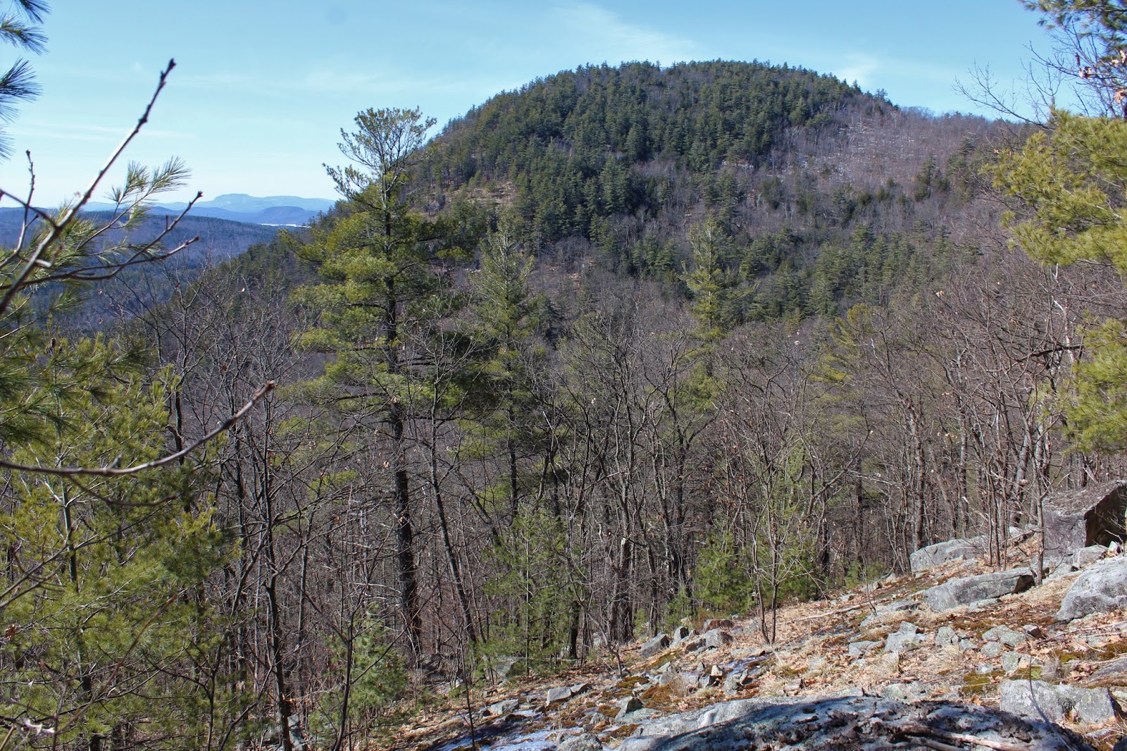
After a couple drops and reclimbs, I soon hit the Pilot Knob herd path, with faded red paint blazes to follow.  The terrain was fairly steep, and covered in fallen pine needles. 
 
The path ranged from easy to follow to seemingly disappearing at times, but for the most part I had no issues.  Nearly all of the mountain was snow and ice free, save some sheltered pockets and a few spots near the top of the ridge.  As I neared 1500 feet, I hit an open meadow just off the herd path.  These were the first expansive lake views of the day, covering a large portion of the lake's southern basin. 
Beyond the open meadow, the herd path winds its way up the steep ridge, with better and better glances down over the lake.
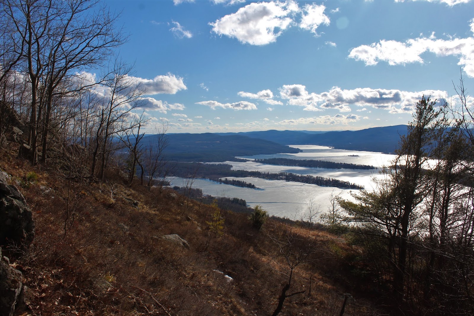
Emerging at one of many wide open view points, I captured this look at the southern end of Lake George.  Skies were clearing and winds were shifting around to the west, battering me on the exposed ridge.
A look up the mostly open ridge.
Although there is a herd path, it is so open that you feel free to roam around soaking in the views without fear of losing the path.
From atop the ridge, views to the north open up above the trees, towards neighboring Buck Mountain(right) and the Tongue Range(distant left)
 
There are almost too many photo ops on this ridge, making it hard to narrow down which ones to include on this page.
West/ NW views towards the many peaks that make up the southern Adks.  The ski slopes on Gore are clearly visible to the right.
To the north, clouds were beginning to roll in ahead of lake effect snow squalls.
South/ SW views stretching down into Saratoga County.
Pilot Knob's summit looming to the south.  I wouldn't be going all the way there today.
Sun soaked Lake George, with the last of the wintry ice vanishing on the lake.
Continued all the way to the last drop before the summit.  Having already been there and due to the late hour, this was my turn around spot.  
I decided to dip into the trees for a little cover from the battering winds.  It didn't provide a lot of protection, but did help. 
Heading back with skies darkening a bit.
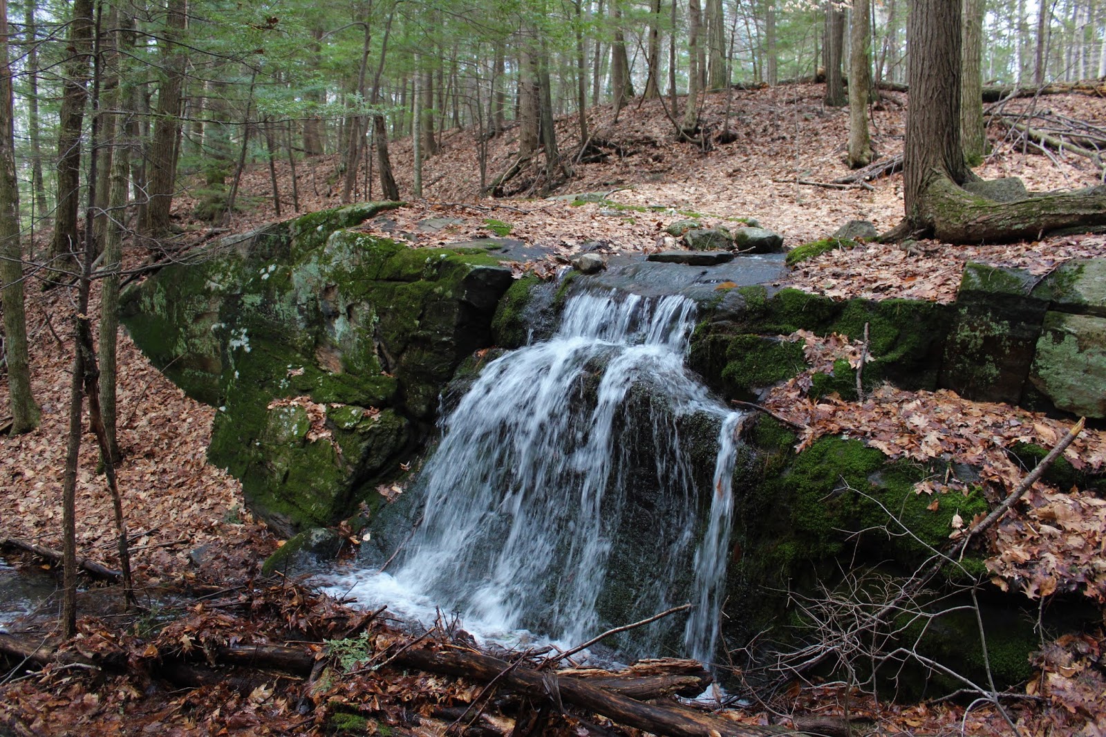
Was glad to finally get back down into the woods, descending steadily off the ridge and back down towards the Inman Pond Trail.  Just prior to hitting the marked trail I found this pretty cascade draining the slopes above. 
Hiked about 5.6 miles RT with nearly 2100 feet of ascent.  One of the most photogenic hikes in the Adk's in my opinion. Side note-I picked two ticks off my pants at the end of the day.  Yes, spring is in full swing.
Blue X=Stewart's Ledge     Red X=Pilot Knob Ridge