Well, the sunshine sure looked nice from the windows at work, but a stiff breeze and temps in the upper 20's made it feel a bit more uncomfortable once I was actually out there. Took a nice, leisurely post work stroll around Schodack Town Park, which is still looking very wintry on this early Spring day.
After exploring the trails along the west side of the park, I crossed over the road to access the east trails.
The last couple of days and nights have brought unseasonably cold weather, meaning tricky footing on crusty snow and ice.
Looped back down through the woods to the Moordener Kill.
Although the wind was cold, the sun sure felt nice. Continued along the creek for a bit, before looping back to the car.
Winter is holding on tight, but its just a matter of time before spring wins out. Hiked about 1.5 miles total.
Adventures around the Capital Region area of New York State, as well as the Adirondacks, Catskills, Berkshires and Vermont
Search This Blog
Thursday, March 23, 2017
Tuesday, March 21, 2017
Joe Baker Sag/ Huckleberry Mountain(Southern Adirondacks)
Was invited by my buddy Jim to bushwack a couple of small peaks in the Lake George Wilderness with a couple of other friends, Spencer and Melissa. Have hiked one other time with Spencer and this was my first time meeting Melissa. We would be hiking Joe Baker Sag and Huckleberry Mountain, just north of Lake Luzerne and east of the Hudson River. We parked at the end of the maintained section of River Road and headed north along the continuation of the road at an elevation of about 600 feet.
After nearly a half mile, we left the road and began the bushwhack into the woods. After some ascent, we came to our first view of Joe Baker Sag's bump, through the trees.
Continuing through the woods, we soon began to really begin to climb.
Heading up.
We hit some steeper rock ledges near he southwest summit of Joe Baker Sag, soon emerging at some very nice views out over the Hudson River.
The southwest views just below Joe Baker Sag's 1450 foot summit.
Stopping to enjoy the views with good company.
After nearly a half mile, we left the road and began the bushwhack into the woods. After some ascent, we came to our first view of Joe Baker Sag's bump, through the trees.
Continuing through the woods, we soon began to really begin to climb.
Heading up.
We hit some steeper rock ledges near he southwest summit of Joe Baker Sag, soon emerging at some very nice views out over the Hudson River.
The southwest views just below Joe Baker Sag's 1450 foot summit.
Stopping to enjoy the views with good company.
We continued on to the wooded high point of Joe Baker Sag, which is pretty nondescript.
Our next peak for the day, was Joe Baker's higher neighbor to the east, Huckleberry Mountain. Again the summit didn't have much to offer, but the open slopes on the southwest side of the mountain were very attractive.
An open meadow like area provided some very pleasant views to nearby peaks.
We were all very impressed with the wide open patches along much of the slopes. The views continued to impress nearly the entire time.
A glimpse west deep into the valley.
An opening provided a view towards a shoulder of Joe Baker Sag, which we had just ascended.
This was a very fun descent, with constant views nearly the entire way.
The warming snow and steep, rocky slopes made for a quick, sliding decent off the mountain.
On the return to the car, we took the trail along the interesting Bear Slides of Buttermilk Brook.
The Bear Slides drop a couple hundred yards and are quite magnificent. Unfortunately, the deep snow and ice took away just how impressive this area can be.
Hiked about 6.5 miles with over 1300 feet elevation gain through deep, compacting snow.
Monday, March 20, 2017
Robert Ingalls Preserve(Stephentown)
Welcome to Spring! Spring began at 6:29am this morning and as exciting as that sounds, the foot+ of snow on the ground and temperatures in the teens overnights certainly have it feeling very much like winter still. Bright sun boosted the thermometer into the 40's today, continuing our slow and steady snow melt and making for pleasant snowshoe conditions. With only about an hour of daylight left, I opted to do a very local walk at the Robert Ingalls Preserve in the deep woods of Stephentown. Although the parking lot hasn't been plowed, the snow has receded just enough to allow me to park the car off on the shoulder of the road. The bright sun and a single pair of snowshoe tracks greeted my first steps into the woods.
Dropping down to Black Brook and bridge crossing.
Most of the brook is still snow and ice covered in the shade of the dark woods.
A couple of small spots with open water along the brook.
I crossed the bridge and then took the brook trail, which is the same spot I lost the other snowshoe tracks. From this point on, I was breaking trail through several inches to a foot of slushy snow.
The evening sun setting on my snowshoe tracks.
Dropping down to Black Brook and bridge crossing.
A couple of small spots with open water along the brook.
I crossed the bridge and then took the brook trail, which is the same spot I lost the other snowshoe tracks. From this point on, I was breaking trail through several inches to a foot of slushy snow.
The evening sun setting on my snowshoe tracks.
After leaving the Brook Trail, I did the Rock Polypody Fern Trail, looping back to the Ridge Trail and then the Main Trail for a total of about 1.5 miles RT.
Monday, March 13, 2017
Daley Ridge(Catskills)
Today was the calm before the storm. With a potentially historic snowstorm knocking on our doorstep tomorrow, I opted to get out and do a nice hike in the Catskills this afternoon. Today's goal was to hike from Notch Inn Road in Edgewood at an elevation of 1780 feet all the way up and across scenic Daley Ridge, towards Plateau Mountain's south slopes above 3500 feet. I left my car at a small parking area along gravel Notch Inn Road, right beside a small bridge crossing. From there, I hiked up the road towards the last house and then continued heading up on an old extension of the road. This old road is very rocky and obvious and is marked with yellow trail markers.
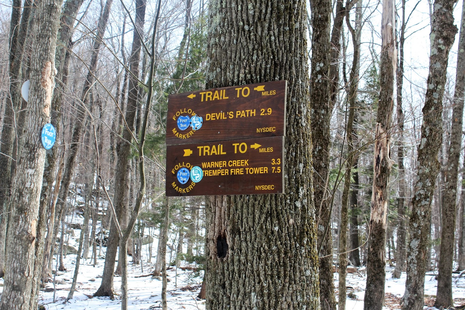
The old road is badly eroded in spots and climbs steadily, nearly 600 feet up through Silver Hollow Notch where you arrive at a trail sign. To the right the Warner Creek Trail heads up and over Silver Hollow(Edgewood Mountain), and to the left, the blue blazed Warner Creek Trail heads up and over Daley Ridge towards Plateau Mountain. I turned left.
The trail begins level for a bit, but soon begins climbing at a steady rate using switch backs to ease the grade. As I ascended, the view behind me through the bare winter trees became quite nice.
The climb up the mountain is made much more interesting by passing up, through and over jumbled rocks and large boulders.
Switchbacks are used to ascend these impressive rock ledges towering above the trail.
The first view point is just a few yards off the trail and provides quite an impressive look west across the notch towards 3000 foot Silver Hollow Mountain.
The ascent up Daley Ridge continues and soon comes to another viewpoint. This view to the southeast isn't quite as broad, but does provide a nice look towards 3440 foot Olderbark Mountain.
Just a few feet off the trail, I managed to find some large rock ledges that offered up some screened views down towards the Warner Creek valley.
The trail soon levels out as it crests Daley Ridge and enters a spruce and fir forest, which lasts for a bit over half a mile. You have climbed over 1300 feet at this point, so the level ridge walk is quite a welcome change.
After passing through the spruce and fir, the trail enters more of a mixed forest and drops slightly, before resuming a climb up the southwest slopes of Plateau Mountain. A nice view point on the right gives a great shot of the summit ridge some 400 feet above.
The same viewpoint also offers a fantastic shot back at Daley Ridge, which you had just climbed over.
Pushing on, the trail rises to the northeast, soon arriving at a 3500 foot elevation sign. A spring is found via a short, spur path to the right. The trail ascends nearly vertical past this sign up to the last viewpoint of the day.
Southwest view.
Really enjoyed the views, but unfortunately due to a late start decided to turn back before continuing on to Plateau Mountain's 3840 foot summit. Having already summited Plateau, this wasn't a big deal. On the return hike, I stopped again at the rock ledge overlooking the Warner Creek Valley with Olderbark Mountain(L), and Daley Ridge(R).
Olderbark Mountain's long ridge line to the south.
I took my time with the steep descent, enjoying the hike back. Round trip was about 6.5 miles, with an elevation gain of nearly 1800 feet. A very scenic area right smack dab in the middle of the Catskills. These peaks will all look much different by this time tomorrow.
The old road is badly eroded in spots and climbs steadily, nearly 600 feet up through Silver Hollow Notch where you arrive at a trail sign. To the right the Warner Creek Trail heads up and over Silver Hollow(Edgewood Mountain), and to the left, the blue blazed Warner Creek Trail heads up and over Daley Ridge towards Plateau Mountain. I turned left.
The trail begins level for a bit, but soon begins climbing at a steady rate using switch backs to ease the grade. As I ascended, the view behind me through the bare winter trees became quite nice.
The climb up the mountain is made much more interesting by passing up, through and over jumbled rocks and large boulders.
Switchbacks are used to ascend these impressive rock ledges towering above the trail.
The first view point is just a few yards off the trail and provides quite an impressive look west across the notch towards 3000 foot Silver Hollow Mountain.
The ascent up Daley Ridge continues and soon comes to another viewpoint. This view to the southeast isn't quite as broad, but does provide a nice look towards 3440 foot Olderbark Mountain.
Just a few feet off the trail, I managed to find some large rock ledges that offered up some screened views down towards the Warner Creek valley.
The trail soon levels out as it crests Daley Ridge and enters a spruce and fir forest, which lasts for a bit over half a mile. You have climbed over 1300 feet at this point, so the level ridge walk is quite a welcome change.
After passing through the spruce and fir, the trail enters more of a mixed forest and drops slightly, before resuming a climb up the southwest slopes of Plateau Mountain. A nice view point on the right gives a great shot of the summit ridge some 400 feet above.
The same viewpoint also offers a fantastic shot back at Daley Ridge, which you had just climbed over.
Pushing on, the trail rises to the northeast, soon arriving at a 3500 foot elevation sign. A spring is found via a short, spur path to the right. The trail ascends nearly vertical past this sign up to the last viewpoint of the day.
Arriving at the viewpoint, which is nothing more than an open ledge.
The open ledge, however, provides outstanding views(quite possibly the best of the day) south over Daley Ridge and extending all the way towards the Burroughs Range beyond.Southwest view.
Really enjoyed the views, but unfortunately due to a late start decided to turn back before continuing on to Plateau Mountain's 3840 foot summit. Having already summited Plateau, this wasn't a big deal. On the return hike, I stopped again at the rock ledge overlooking the Warner Creek Valley with Olderbark Mountain(L), and Daley Ridge(R).
Olderbark Mountain's long ridge line to the south.
I took my time with the steep descent, enjoying the hike back. Round trip was about 6.5 miles, with an elevation gain of nearly 1800 feet. A very scenic area right smack dab in the middle of the Catskills. These peaks will all look much different by this time tomorrow.
Friday, March 10, 2017
Sunset Rock/ Bash Bish Mountain(South Taconics)
Took advantage of a free afternoon by doing a post work hike Thursday at scenic Taconic State Park, located in Copake Falls just west of the Massachusetts state line. Another reason I was anxious to get out was because the forecast for the next several days looks pretty cold and potentially stormy. I parked at the main parking lot for Bash Bish Falls along Route 344 and was pleasantly surprised to only see three other cars in the lot, all on the far side of the lot(for the falls). I crossed Route 344 to the north finding the Cedar Brook Trail, marked with a trail sign. Elevation to start the hike was 732 feet.
I would be heading north on the Cedar Brook Trail for 1.1 miles to the South Taconic Trail, which would lead me to Susnet Rock at 1.7 miles.
The Cedar Brook Trail is very rugged, beginning high above the brook and hemmed in by the steep walls on each side. As the hike continues to the north, the brook will soon be by your side.
I really enjoyed the hike along Cedar Brook, with its tiny pools and cascading water.
The trail crosses the brook five times, meaning that you will need to carefully rock hop across each time to keep your feet dry. In times of high water, this trail may be impassable.
Crossing over Cedar Brook easily by rock hopping.
After the last brook crossing, the trail abruptly turns west and begins a very steep climb out of the gorge.
Once out of the steep gorge, the trail enters a deciduous forest and eventually meets up with the South Taconic Trail, running north-south. I turned right(north) onto the wide STT and soon passed beautiful, old stone walls.
After a brief level stretch, the trail begins to climb in earnest, up a rocky slope.
Heading uphill toward the crest of the rise. As the trail nears Sunset Rock, the woods change quite drastically to mountain laurel, scrub oak and pitch pine.
You will soon arrive at a large clearing with a spur trail to the left(west), leading to Sunset Rock. A sign used to mark this turn, but now you must be keep your eyes open for this turn. Once on the spur trail, the vegetation seems to really in on you, creating a tunnel effect.
Emerging at Sunset Rock, elevation 1788 feet.
The views from atop Sunset Rock are outstanding, making the 1000+ foot climb worth while.
The Catskills stand prominently some 30 miles away, with the rolling farmland of Columbia County stretched out in the foreground.
There is another rocky clearing a few yards away, which provides pretty much the same view. Perhaps this look to the south is improved slightly from the second rock clearing.
This makes a tremendous spot to stop and soak in the views, but unfortunately a stiff wind kept me from really enjoying my time here.
After finally turning back, leaving Sunset Rock, I headed back south on the South Taconic Trail, this time bypassing the Cedar Brook Trail. Continuing on the STT south(blazed in white), the trail soon becomes a wide, old wagon road. Southeast views towards Bash Bish Gorge are quite impressive, even through the trees.
More screened views down to south.
The South Taconic Trail heads steadily downhill, passing through several different forest types and eventually meeting up with a gravel park service road.
The trail descends down toward the west side of Cedar Brook and back to the parking lot on Route 344 for a 3.8 mile Round Trip hike. The afternoon shadows were starting to creep in so I paused at the car to consider my options. After a quick glance at my BNRC South Taconic Trail Map I decided to continue south for another 1+ mile to the Bash Bish Mountain view point. Dropping down from the parking lot, I followed the white blazes along a park road, which crosses over Bash Bish Brook and leads to a cabin. Turn sharply right at the cabin, where a sign for Bash Bish Mountain indicates that it is 2 miles ahead.
The trail begins climbing immediately, very steeply at first.
After about one mile, the steep ascent eases just a bit, nearing the shoulder of the mountain.
You must be vigilant to notice the spur path that leaves the STT on the left(west)and leads to some pretty incredible views. Elevation along this viewpoint is just over 1500 feet, meaning you climbed nearly 800 feet in one mile.
A glimpse southwest into the late afternoon sun, with the south slope of Washburn Mountain.
The open rock upon this shoulder of the mountain is very inviting and provides some pretty amazing views to the west. Hard to believe I haven't heard much about this spot, as the views are as good as any I've seen in the Taconic region.
A zoomed view down to the trail head down along Route 344 far below.
Looking northwest into rural Columbia County along the rocky spine, which can be fully explored.
As I wandered the rocky ledges, I was fortunate to spot nearby Cedar Mountain, rising directly to the north. Looks like there are some pretty impressive rock cliffs way up high, which may provide some nice views.
With the day growing old I decided against climbing to the top of the mountain, heading back down the steep trail.
Crossing back on the bridge over Bash Bish Brook.
I would be heading north on the Cedar Brook Trail for 1.1 miles to the South Taconic Trail, which would lead me to Susnet Rock at 1.7 miles.
The Cedar Brook Trail is very rugged, beginning high above the brook and hemmed in by the steep walls on each side. As the hike continues to the north, the brook will soon be by your side.
I really enjoyed the hike along Cedar Brook, with its tiny pools and cascading water.
The trail crosses the brook five times, meaning that you will need to carefully rock hop across each time to keep your feet dry. In times of high water, this trail may be impassable.
Crossing over Cedar Brook easily by rock hopping.
After the last brook crossing, the trail abruptly turns west and begins a very steep climb out of the gorge.
Once out of the steep gorge, the trail enters a deciduous forest and eventually meets up with the South Taconic Trail, running north-south. I turned right(north) onto the wide STT and soon passed beautiful, old stone walls.
After a brief level stretch, the trail begins to climb in earnest, up a rocky slope.
Heading uphill toward the crest of the rise. As the trail nears Sunset Rock, the woods change quite drastically to mountain laurel, scrub oak and pitch pine.
You will soon arrive at a large clearing with a spur trail to the left(west), leading to Sunset Rock. A sign used to mark this turn, but now you must be keep your eyes open for this turn. Once on the spur trail, the vegetation seems to really in on you, creating a tunnel effect.
Emerging at Sunset Rock, elevation 1788 feet.
The views from atop Sunset Rock are outstanding, making the 1000+ foot climb worth while.
The Catskills stand prominently some 30 miles away, with the rolling farmland of Columbia County stretched out in the foreground.
There is another rocky clearing a few yards away, which provides pretty much the same view. Perhaps this look to the south is improved slightly from the second rock clearing.
This makes a tremendous spot to stop and soak in the views, but unfortunately a stiff wind kept me from really enjoying my time here.
After finally turning back, leaving Sunset Rock, I headed back south on the South Taconic Trail, this time bypassing the Cedar Brook Trail. Continuing on the STT south(blazed in white), the trail soon becomes a wide, old wagon road. Southeast views towards Bash Bish Gorge are quite impressive, even through the trees.
More screened views down to south.
The South Taconic Trail heads steadily downhill, passing through several different forest types and eventually meeting up with a gravel park service road.
The trail descends down toward the west side of Cedar Brook and back to the parking lot on Route 344 for a 3.8 mile Round Trip hike. The afternoon shadows were starting to creep in so I paused at the car to consider my options. After a quick glance at my BNRC South Taconic Trail Map I decided to continue south for another 1+ mile to the Bash Bish Mountain view point. Dropping down from the parking lot, I followed the white blazes along a park road, which crosses over Bash Bish Brook and leads to a cabin. Turn sharply right at the cabin, where a sign for Bash Bish Mountain indicates that it is 2 miles ahead.
The trail begins climbing immediately, very steeply at first.
A small creek was running fervently beside the trail, as the ascent continues.
The trail heads south for a distance and levels out for a bit, then turns to the east and climbs even more steeply.After about one mile, the steep ascent eases just a bit, nearing the shoulder of the mountain.
You must be vigilant to notice the spur path that leaves the STT on the left(west)and leads to some pretty incredible views. Elevation along this viewpoint is just over 1500 feet, meaning you climbed nearly 800 feet in one mile.
A glimpse southwest into the late afternoon sun, with the south slope of Washburn Mountain.
The open rock upon this shoulder of the mountain is very inviting and provides some pretty amazing views to the west. Hard to believe I haven't heard much about this spot, as the views are as good as any I've seen in the Taconic region.
A zoomed view down to the trail head down along Route 344 far below.
Looking northwest into rural Columbia County along the rocky spine, which can be fully explored.
As I wandered the rocky ledges, I was fortunate to spot nearby Cedar Mountain, rising directly to the north. Looks like there are some pretty impressive rock cliffs way up high, which may provide some nice views.
With the day growing old I decided against climbing to the top of the mountain, heading back down the steep trail.
Crossing back on the bridge over Bash Bish Brook.
Arrived back at the car with about a half hour of daylight remaining. A fun afternoon in the Southern Taconics. Hiked about 6 miles RT, with 1850 feet elevation gain.
Subscribe to:
Posts (Atom)