Search This Blog

Monday, August 31, 2015

Dix Range(Dix Mountain)-Adirondacks Day 2

Woke up bright and early on a crisp, cool Saturday morning.  We were lucky to have to Lillian Brook Lean To to ourselves last night and quickly got breakfast going.  Hot coffee definitely took a bit of the chill off this 50 degree morning and after cleaning up the site, we were ready to hit the trail.
 We headed off on the Dix Trail, which quickly comes to Lillian Brook's crystal clear mountain waters.
 This made the perfect spot to stop and load up on some cold water for the day using our steripen purifiers.
 The trail had a few ups and downs as it headed north.
 Just before arriving at the trail junction, Dix Pond can be spotted to the west off the trail about 20 yards.  A couple of small footpaths lead to the shore for a better look.
 Once arriving at the trail junction, we chose to go right on the steeper but slightly shorter trek up to Dix Mountain via the Beckhorn.  A left takes you to Hunter's Pass and along the west and north side of the mountain.  The trail climbs steadily up about 2600 feet.
 An open view point back towards Clear Pond to the south.
 A steeper section.
The incredible slides on Hough and South Dix's west facing slopes.
A ledge on the way to the Beckhorn, with the rest of the Dix Range to the left.  Hough in the foreground with Grace peaking over its shoulder, South Dix and Macomb are found just to the right with Elk Lake in the center of the frame.
 A rocky ledge provides outstanding views and made a perfect spot to rest and snack.
 This sign is posted a few yards past the ledge.
 Emerging from the woods and hitting rocky cliffs.
 That's me way up there.
 A huge rock makes for an interesting climb and amazing views.
 From the 4779 foot Beckhorn is an incredible view of the actual peak of Dix.
 Mark approaching the summit of 4857 foot Dix.
 A great view back at the Beckhorn on the final climb up Dix.
 Me on the summit of 4857 foot Dix Mountain, the sixth highest in the Adirondacks.
A summit view to the west over Elk Lake.
The vistas are endless from the rocky summit area.  We shared the top with several other parties, including a young lady celebrating becoming a 46er.
 It was a fun descent off the mountain with great views nearly the entire time. 
Got back to the car, pretty exhausted but all very happy.  About 9.6 miles for the day and 22.6 miles RT for the two days.  A great adventure.

Dix Range(Macomb, South Dix, Grace, Hough)-Adirondacks-Day 1

Went on an overnight trip to the Adirondack High Peaks with a couple of old friends this weekend.  We wanted to hike the entire Dix Range in the southeastern High Peaks and our game plan was to nab four(Macomb, South Dix, Grace, Hough) the first day and then summit Dix on day two.  We arrived at the Elk Lake Road parking area at about 7am Friday morning and were lucky enough to get a spot by the trail head.  After getting all geared up and ready to go we were ready to hit the trail, all in great spirits.
 By 8am we were on our way on the Dix Trail.
 The Dix trail starts at the south end of Elk Lake and then runs along its east side, crossing Little Sally Brook, Big Sally Brook, and Slide Brook on our way to the Lillian Brook Lean To.
 After dropping some of our heavier gear at the Lean To we returned .3 miles back to a rock cairn, which marked the herd path to Macomb Mountain.
 The herd path closely follows Lillian Brook much of the way, even crossing it more than once.
 The path gets increasingly steeper towards the col.  Although unmarked, it is pretty easy to follow.
We soon arrived at Macomb's 4405 summit, with broad views to the south, west and north.  Elk Lake is the most prominent feature in the middle of this panorama.
The summit of Macomb.
After soaking in the vista from the summit, we descended back down to the col between Macomb and South Dix before beginning the ascent up the rocky trail.
I apologize for the sweat on the lens, but this was a very fun and gorgeous rock scramble up the side of South Dix.
Continuing up South Dix.
The completely open climb afforded a great view back at Macomb Mountain, which we had just come off of.
The actual summit of 4068 foot South Dix(soon to renamed Carson Peak) is wooded, with the only marking we could find wbeing the letters SD carved into a tree.
 Continuing past South Dix, we followed the herd path northeast to East Dix(Grace Peak).

Grace Peak's 4026 foot summit provides incredible open vistas to the north, east and south.  
Looking south from Grace.   Although only ranked 42nd out of the 46 high peaks in height, the views rank much higher on the list.
A sliver of Schroon Lake can be seen to the nearby south and east.
After enjoying our lunch at the summit area, we retraced our steps back towards South Dix's summit, where a rock cairn marks a herd path towards Hough Peak.
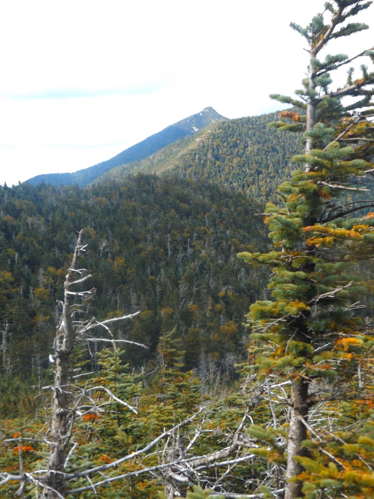
Almost immediately after starting this path, you are rewarded with a view of Hough(to the right and partially behind the tree) and Dix.

The path descends steadily down to a col, where a camping spot with fire ring can be found.  From there the path is steep and rugged up Hough's east side.
Just before Hough's summit, there is a rocky ledge which provides fantastic views.  Here's a view of Grace Peak and its slides.
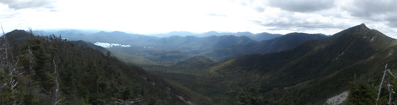
A panorama from Hough's south ledges. 
About .2 of a mile past the ledges is the actual summit of 4409 foot Hough Peak.
A great view of nearby Dix Mountain from Hough.
A panoramic view from South Dix all the way over to Dix.
 We retraced our steps back down to the col between Hough and South Dix, where another herd path heads steeply back down to the Lillian Brook path.  This path is a little harder to locate but it is basically a rock cairn several yards behind the fire pit at the camping spot. From there it is a pretty steep descent(36% grade).  We arrived back at the Lillian Brook Lean To at dinner time and had the place to ourselves.  There was another couple of groups camped near the brook and further back in the woods.  We ate some dinner, set up camp and were all ready for a good night's sleep.

Completed about 13 miles RT for the day.  We all slept like a rock.

Wednesday, August 26, 2015

Russell Brook Falls/ Trout Pond/ Schoharie Reservoir(Western Catskills)

Went for a nice road trip with my dad today to New York's southern tier and western Catskills.  We visited the Delaware River along the NY/ Pennsylvania state line where fly fishing is a favorite past time.
The river is wide and mellow with multiple access sites available along both shorelines.
The first trail we hit was in the southwestern Catskills at the Russell Brook Road trailhead.  The trail is found by taking Route 206 north out of Roscoe to Morton Hill Road on the left(just past the bridge over the Beaverkill) and then watch for gravel Russell Brook Road again on the left.  Stay on this road past some camping spots to a parking lot and kiosk.  The trail quickly drops down past the kiosk to the banks of the babbling brook.
Less than .1 of a mile into the hike and just upstream of a bridge crossing are many remnants of an old mill that once stood here.  You can walk around the woods all along the brook here and see many fascinating glimpses into the past.
An old bridge crosses Russell Brook and leads to a large group of blooming apple trees.
Looking carefully on the right, you will spot a small path that leads towards the brook.  From here, the sounds of powerful cascading water will guide you to Russell Brook Falls.
Clear brook water below the falls.
Low water allowed me to explore the area all around the beautiful 23 foot falls.
Russell Brook flowing downstream from under the bridge.
Returning to the main trail, you will pass a trail register at .1 mile at a trail junction.  Taking the right trail brings you up an old, wide woods road.
After about .9 of  a mile, we arrived at Trout Pond's southern shore.
We explored the shoreline of this beautiful pond, formerly known as Cables Lake.  There is a nice, informal campsite along the west shore, and an easy to follow path for fisherman along nearly the entire shore. A Lean To is found half a mile north on the opposite side of the pond, but didn't want to push it with my dad's ailments.  After lingering at the pond for a bit, soaking in the solitude, we returned back on the woods road to the truck.  Nice, short 1.8 mile RT.
After leaving Trout Pond, we took a nice drive north through the Catskills to the Schoharie Reservoir, New York City's northernmost reservoir.  There are many access points on both sides of the water, but almost all are steep.  We parked at an informal spot along the southwest side of the Reservoir, on Intake Road.  From there we strolled down through a tiny path which drops down to a rocky outcrop, and great view of a waterfall on Bear Kill stream.
The water really crashes down here, just below the bridge on Intake Road.  From here the Bear Kill flows a short distance downstream into the Reservoir.
Looking upstream at the Schoharie Reservoir.  We followed some informal paths that wander down through the woods, past old foundations and several canoes to a few different spots along the south end of the Reservoir. 
We didn't hike a lot due to my dad's lingering injury, but we really enjoyed getting out exploring on a nearly perfect summer day.