Search This Blog

Monday, January 29, 2018

Mongaup Mountain to Sand Pond Mountain to Willowemoc Mountain(Catskills)

Met up with my buddy Jim for another Catskill hundred highest traverse, this time in the far southwestern Cats, on a beautiful late January day.  We first opted to bushwhack up 3177 foot Mongaup Mountain(which we had both previously summited). 
 Some ledges on the northeast side of the peak provided a nice framed view down over the Beaverkill valley.
 Mongaup's summit is a large flat plateau, but we did manage to find this small man made fire pit near the middle of the summit.
 The drop off on the east side of Mongaup is fairly steep in spots, making for a fun little descent down into the col, on our way to the next small 2863 foot bump.
 One of the reasons I love going off trail exploring....a small, pretty meadow high up between Mongaup's two eastern summits,
 With temps once again above freezing today, streams and drainages that were frozen solid have now began flowing (mostly) free again.
 A final push up to the 2980 foot bump just west of Sand Pond Mountain, the last bushwhack part of the day.
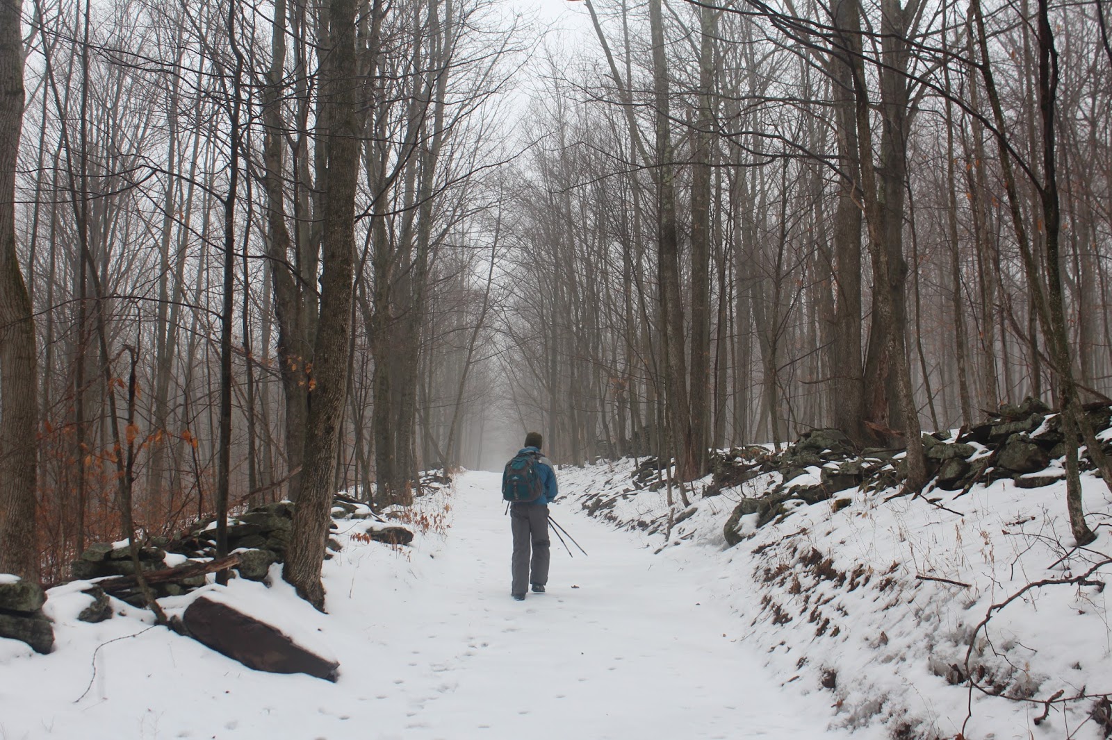
 Arriving at the blue blazed Mongaup-Hardenburg trail.
A look back at the 2980 foot peak just west of Sand Pond Mountain, as we begin a steep push up.
 While most of the day was almost completely snow free, there were some protected spots above 3000 feet, where wintry conditions still prevailed.
 The marked trail is very lightly used and therefore easy to lose in spots.  Very little trail maintenance is done, so blowdown and missing trail markers can make it difficult to stay completely on trail.
 The trail skirts the summit area, which was a short bushwhack off trail.  Arriving at Sand Pond Mountain's 3062 foot wooded summit, we took a small lunch break.
 Wandered the ledges along Sand Pond's summit ridge and managed to squeak out this sliver of a view to the northwest
 A small ledge near Sand Pond Mountain's summit provided a nice view to Willowemoc's 3224 foot summit, our next destination.
 An interesting swampy meadow just below Willowemoc's summit.
 The 3224 foot wooded, nondescript summit of Willowemoc sits only about 25 yards off trail. My 81st Catskill Hundred Highest! 81/102.
 A small window just east of Willowemoc's summit provided a glimpse all the way back to Mongaup, our first peak of the day.
The steep descent off Willowemoc, on our way north to the Beaverkill.  Part of Mill Brook Ridge and Woodpecker Ridge can easily be seen through the bare winter trees.  Balsalm Lake Mountain is seen rising beyond.
 The swinging bridge which spans the historic Beaver Kill
 The famed Beaver Kill, which is said to have been the birthplace for fly fishing in America.
 Jim, crossing over the creek, putting a cap on another outstanding day in the Cats. 
Arrived back at the spotted car after 11 miles and 2300 foot of ascent.
I've driven by this dilapidated barn on Barkaboom Road countless times and it always catches my eye. The overcast mid winter conditions seemed to be a perfect fit.

Thursday, January 25, 2018

Thacher Park

Went for a short walk after work this afternoon at Thacher Park atop the Helderberg escarpment. Parked in the Paint Mine parking lot and set out on a sunny, but breezy and cold day.  A far cry from its mid summer popularity, as I was the only car in the lot when I arrived. I started along partly frozen Mine Lot Creek.
Followed along the creek for a bit, checking out the wintry waterfalls, which can be quite scenic this time of year.
Crossing the creek onto the Nature Trail is where the real ice began.  Luckily, I had brought my Hillsound spikes so it was easy going.
Did the full 1.1 mile Nature Trail loop which circles back along the creek.  There was a little more snow in the shaded areas a bit higher up.
 More cascades along the creek.
 Hitting the home stretch with the cold winter wind putting a chill through me.
The ice has really built up in some spots so spikes may have to be an option for folks out walking the next few days.
Hiked about 1.3 miles total.

Monday, January 22, 2018

Irish Mountain & #Shultice Mountain(Catskills)

PLEASE NOTE-THESE PEAKS ARE PRIVATE!  WE SECURED CONSENT WITH LANDOWNER BEFORE HIKING
Headed out to the western Catskills with my buddy Jim to hike a couple more Hundred Highest Catskill peaks on a dreary, foggy, but mild(for January) morning.  With consent to hike the peaks in hand, we headed over to a logging road to begin our hike up the east side of 3060 foot Irish Mountain.  The logging road was lined with classic Catskill stone walls and even barbed wire.  Elevation to start the day was about 1800 feet.
 At first the logging road climbs gradually through a deciduous forest.  The fog added a very peaceful feeling to the hike.
 In all of my Catskill hiking, I'd have to say that the Delaware County peaks have the most stone walls I've seen. 
 Jim ascending via the logging road on about 2 or 3 inches of consolidating snow.
 I simply cannot get enough of the beautifully hand crafted stone walls, which lace the lower slopes of Irish Mountain.
 We left the logging road to take aim for the north ridge of Irish, climbing up through a thick fog.
 The sun did its best to break through the clouds, and actually made for a very nice scene.
 Arriving at the summit bump, a little above 3000 feet, we left the fog behind.  Almost seemed like we steeped through the door into a different world.
 With temps climbing through the 30's, we both were quite warm in all our winter garb.  At the summit, we decided to lose a layer or two as we enjoyed a snack break.  My 79th CHH.
 Continuing past the summit, we took aim for our next destination.  We passed through some prickers along the way, but without their mid summer bite.
 We dropped down to about 2750 feet between the peaks, before continuing south towards Sultice.  The ascent was mostly gradual, with one steeper push near the summit.
 Unfortunately I got the lens wet, but here we are arriving at the 3289 foot summit.  My 80th CHH!!!
We retraced our steps back off #80, heading back towards Irish Mountain.
The slopes of Irish are extremely steep, and with melting snow and a light mist, made for a slippery descent.
 From a small pond just off the logging road near our car, we spotted a gorgeous view of the long ridge of Shultice and Irish.
Two more Catskill hundred highest peaks off the list.  6.5 miles RT with 1800 feet elevation gain.

Monday, January 15, 2018

The Wildcat Range(Catskills)

After every conceivable issue the last few weeks, I finally had an opportunity to get out for a winter hike with my buddy Jim on Monday.  We discussed some options and settled on a full traverse of the Wildcat Range in the South-Central Catskills.  The range is not well known to many, but has seven summit bumps with two prominent Catskill Hundred Highest peaks among them.  It's claim to fame, however, is probably that the Wildcats are Slide Mountain's western neighbor.  Because there are no trails on the range itself, there are many different bushwhack options, with most centering on the two prominent peaks(West Wildcat & East Wildcat).  We wanted to add a twist to the hike, so we parked a first car at the Slide Mountain trailhead, then drove south about 15-20 minutes to DEP land along Wildcat Mountain Road.
 
 Wildcat Mountain Road is a lovely high elevation, dead end, gravel road with several camps and even a couple of year round residents.  We decided to walk the scenic road for about a mile, until its terminus.  Elevation to start the day was a lofty 2250 feet. Took a moment while passing by this apple tree in the front yard of a lonely looking seasonal camp.
The end of the maintained part of Wildcat Mountain Road is the start of DEC land.  A very rough road continues into an open hardwood forest.   
 Jim leading the way on a cold, but pleasant winter morning.  Temps to start the hike were in the single digits, but a lack of wind made for comfortable going.
 Gorgeous stone walls just off the woods road.
We were both a bit surprised to see almost no snow or ice until about 2500 feet. Even then, the snow wasn't much more than a dusting to an inch.  The ice was quite impressive however.  We carried spikes in our packs but bare booted the whole day.
 A light dusting of snow covering a batch of shining clubmoss and evergreen wood fern.
 
  A typical scene along the Wildcats in an almost 100% deciduous forest, making for great bushwhacking.
 
 A final push up our first small  peak, with crunchy, crusty snow underfoot.
 The first bump along the way is a 2865 foot summit without enough prominence to count as its own peak.  Was still very lovely, with a bit more snow and ice at this elevation. 
 The area between peaks is a checkerboard of public and private land, so we were very mindful of this, keeping one eye on our maps as well as the property markings.  
 Arriving at the first "official" peak of the day, the 3160 foot summit of West Wildcat.  
 A small rock cairn marked the summit, my 77th CHH peak.
 
After grabbing a quick bite to eat, we continued on in a northeast direction, climbing up and over a couple of other minor summit bumps on our way to East Wildcat.  Just before the ascent up East Wildcat, we arrived at the gorgeous "bavarian forest".  An unlikely dark, hemlock grove stands in stark contrast to the hardwoods that make up most of this entire range.
 Wandering through this magical hemlock stand.
Just beyond the dark forest, the ascent commenced.  Some of our steeper climbing of the day occurred along this stretch.  Nothing too difficult though.
 
Even over 3000 feet, much of the open areas were snow free, making for easy going. This was the last summit bump before East Wildcat.
Jim wandered along the southeast facing slopes in search of a view, finally finding a nice lookout towards Slide.  East Wildact's long ridge dominates the foreground.
A jumbled pile of rocks on East Wildcat's higher slopes.
As we gained some of our highest elevation of the day, the woods became noticeably more wintry.
The nondescript 3340 foot summit of East Wildcat.  My 78th CHH!  Yeah!
 We continued the bushwhack northeast, heading up and over a couple of other minor 3300+ foot twin summits before a steep drop brought us down to the Curtis-Ormsbee Trail.  From there, it was an icy 1.5 mile trail hike back to the first spotted car.  
Just prior to arriving at the car, we came to a difficult creek crossing over the West Branch of the Neversink.  High water and ice made things very tricky.  We both got wet feet, but managed to cross safely.  A long 11 mile(9.5 bushwhack) hike, with over 1700 feet elevation gain.