Search This Blog

Thursday, June 30, 2022

Warner Hill(Town of Dalton, Berkshires)

Did a quick afternoon hike up Warner Hill along the Appalachian Trail in the central Berkshires after work today.  Parked on the wide shoulder of Grange Hall Road in Dalton(Elevation 1650 feet), where the AT crosses and set out under sunny skies and comfortable conditions. Crossing the road, I headed south on the trail, gradually climbing up through abundant fern glades and the familiar white blazes of the AT.

After only 3/10 of a mile, a blue blazed spur trail leads over to the Kay Wood Shelter, which sits on a hillside above Barton Brook.  The Lean To was occupied by a friendly man from England who was doing a thru-hike.  After chatting for a few minutes, I headed back over to the Appalachian Trail, continuing south.

A bit over a half mile from the car, the trail passes beneath power lines, with decent views southwest into Pittsfield.

The trail basically rolls along uneventfully for about 3 miles, with small ups and downs along the way.  The high point is just off the true summit of wooded 2092 foot Tully Mountain.  A light breeze was enough to keep the bugs at bay today.


Just prior to reaching the summit of Warner Hill, the woods are quickly replaced by open fern glade meadows.  This is a very scenic and unique spot.

From the top of 2050 foot Warner Hill, there are views to the northwest with the Greylock Range on the distant horizon(right).  In the foreground is Tully Mountain, which I had climbed over to get here.  The Taconics are on the horizon, left.

From the summit, I retraced my steps back north to the car for a total of 6.3 miles RT, and a bit over 600 feet of combined ascent.  In addition to the fellow at the Lean To, I only saw two other groups hiking northbound on the trail. 


Monday, June 27, 2022

Unnamed Palmer Pond Peak(Lake George Wild Forest-Adirondacks)

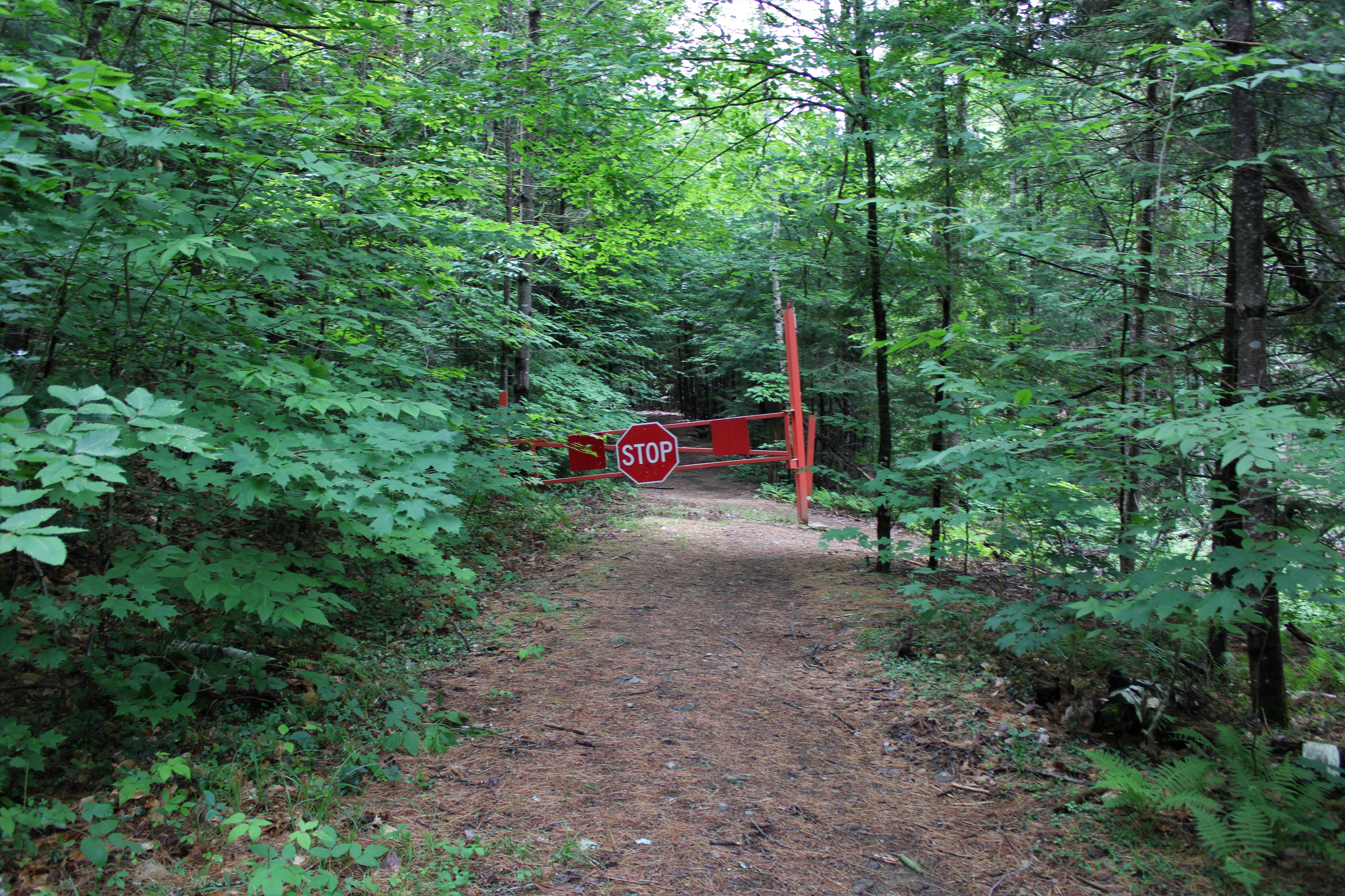
Headed up into the southern Adirondacks to do a little exploring to an unnamed peak near Palmer Pond in Chestertown this morning.  Early morning rain had finally ended and clearing skies prevailed as I arrived at the trailhead at the end of Palmer Pond Road(road was a bit rough for my low clearance vehicle-but I made it just fine)  I was a bit surprised to be the only car there when I arrived, but I gladly set out south on the gated, wide old road that is now the trail.(Elevation 1185 feet).


Within just a few moments on the trail I knew the bugs were going to be more than just a nuisance today, so I donned the head net for the first time all year.  Keeping right at a fork in the trail, I hugged the west side of the pond, passing through a very wet area near the outlet flow.

The main trail on the west side of the pond is very obvious and easy going for about 3/4 of a mile, until I turned right onto a less obvious herd path/ ATV trail marked by three small barrels.  This trail heads west and is in pretty good condition.  There is even a makeshift footbridge crossing over a small stream-not bad for an unofficial/ unmaintained trail. 

The unofficial trail is quite nice, passing through a sea of ferns on its way west.

The trail literally brings you right up to the large, open areas on the steep west slopes below the summit of the unnamed peak I was heading to.  Thankfully, this broad, open area allowed for a nice gusty wind to blow, chasing the bugs away.

Heading over to a jumbled area of rocks on a steep area of ledges, I was treated to the first views of the day towards Mill and Stockton Mountains.

Contouring my way along the steep, west facing slopes I found even more views.  This view stretches far and wide to the west, reaching all the way over to Gore Mountain(distant right).
Mill and Stockton again, from a slightly higher set of rocky ledges.
To the south, Gage Mountain rises impressively.
After checking out the views, I headed up through open patches of sedge grass and rocks on my way to the summit.
Arriving at the grassy, wooded 1580 foot unnamed summit.
From the summit, I came down a slightly different route and found even more views from open rock.  This is a broad view south towards the many peaks near the Hudson River.
SW views from the open rock.  From this higher vantage point, Crane Mountain can be seen on the horizon, left of center.

An easy descent on the unofficial trail, brought me down to the main trail once again.  From there, I circled around the south and east sides of Palmer Pond, enjoying many wonderful water views.

From the NE corner of Palmer Pond, I caught this neat look back towards the unnamed peak I had just hiked.  Doesn't appear to be much more than a small bump from here.

Once back around to the north side of the pond, I picked up the main trail once again and followed it back to the car for a total of 4.2 miles round trip, and over 500 feet of ascent.  Didn't see anyone else until I got back to the car as another group was setting out.  Would've been a perfect day but the bugs were extremely irritating near the pond.  

Map Below.   Blue P=Parking   Red=Route Taken


Saturday, June 25, 2022

Perigo Hill-Geiser Preserve(Town of Sand Lake, Rensselaer County)

Did a short hike on this steamy day to 1873 foot Perigo Hill in Taborton up on the Rensselaer Plateau.  I parked at the end of the maintained part of Lindeman Road, at a snowplow turnaround(Elevation 1550 feet). From there, I simply followed the old road on foot, heading northeast.

Abundant ferns infringe on the sides of the road, as does private property, so I made sure to stay on the road.
Continued north for about 1.25 miles, passing by this pretty, open meadow along the way.
The old road meets up with Eastern Turnpike-an old 19th century turnpike, where I turned left(west) and followed this road for a short spell until I hit the protected lands of the Geiser Preserve. 
The slopes of Perigo Hill are laced with stone walls.
In just under a 1/4 mile, a marked trail leaves the road and heads north, gradually climbing up towards the summit.  This trail doesn't appear to receive much use and is quite overgrown in spots and hard to follow as well.  Fern glades are very impressive and numerous on the way to the summit, making it hard to see your next step much of the time. 
After about 4/10 of a mile on the marked trail, I arrived at the wooded 1873 foot summit, complete with more ferns!
From the summit, I retraced my steps all the way back to the car, enjoying the peace and solitude.  Hiked about 4 miles RT, with only 350 feet of ascent.  An easy hike on a hot day, but the bugs were quite the pests, putting a bit of a damper on my mood.
 

Wednesday, June 22, 2022

Huyck Preserve(Town of Rensselaerville, Albany County)

Decided to pay a visit to the Huyck Preserve, high up in the hills of Rensselaerville in western Albany County on a cool, gloomy-but comfortable day.  Parked at the Visitor Center near the falls, and with the clouds and temps only hovering around 60 degrees, there were only 2 cars in the lot as I arrived.  From the lot, it is a very short walk over to the base of Rensselaerville Falls, which I was lucky enough to have to myself.  Just beyond the first view of the falls, another established trail brings you over to the next(middle) tier of the 120 foot falls.

After all of the oohs and aahs from the falls, the main trail climbs up through a dark, handsome forest on its way towards Myosotis Lake, passing by stoic old stone walls.  After a brief visit on the Myosotis Dam Trail(a 3/10 of a mile dead end trail to the dammed east end of the lake), I continued on the West Lake Trail.  As I made my way through the peaceful woods, a refreshing breeze began to blow and I couldn't help but think that is was perfect hiking weather. Stopped to enjoy a moment of zen just below a footbridge crossing over an unnamed stream near the south end of the lake.
Further along the West Lake Trail, I passed by  the remnants of an old chimney and other crumbling parts of what I assume was some sort of foundation.
The trail hugs the shore of Lake Myosotis, offering up many nice views, such as this foggy look out across the north section of the lake.
A thick fog was really settling in over the lake, creating a beautiful-but eerie feeling.
I hiked all the way up the West Lake Trail to Pond Hill Road and road walk below the dam for Lincoln Pond.  

From there, a short road walk soon dropped me back down into the woods past more stone walls and onto the East Lake Trail, which I quietly meandered along south, eventually making my way all the way back to the car. 
Hiked a nice and easy 3.7 miles total on an overcast, but nice(at least to me) first hike of summer.  I'll take these days over the summertime heat every chance I get!
 

Friday, June 17, 2022

Wahconah Falls State Park(Town of Dalton, Berkshires)

Did a short walk in the Berkshires this afternoon at Wahconah Falls State Park in Dalton.  I've visited the falls several times before and it is always a treat.  A very short walk from the parking lot brings you immediately down to the main, 40 foot waterfall that is the park's namesake.  Unfortunately, there was a rowdy group congregating there so I moved on, checking out some of the smaller, but still pretty cascades and falls further upstream. 


The trail continues north in a shady glen, closely following the course of the brook. Just under a mile of easy hiking along the brook finally ends at a dam and the first views of the Windsor Reservoir.  A very pretty spot for sure.
From the dam, I picked up an unmarked, but obvious herd path that closely hugged the shore of the Reservoir.  There are a few good vantage points to check out the water, but I found one spot at the far north point of the shore that was my favorite. 

Turned around at the point, and walked back to the dam via the herd path, and then an easy walk on the marked trail all the way back to the car.  A very pleasant 2.3 miles total, with about 150 feet of ascent on a gorgeous, breezy mid June day.

Mount Raimer via Green Hollow Access(Town of Berlin, Rensselaer County-Taconics)

Headed into the quiet hills of Rensselaer County today to re-visit Mount Raimer, but this time from a route I haven't done before.  I parked at the end of public access on Green Hollow Road, east of the the village of Berlin in a small, unmarked clearing(Elevation 1310 feet).  I was a bit surprised to see a trail register near the start of the trail, which is actually a very old public road that heads up into Berlin Pass.


The old turnpike was a 19th century road that provided access up to Berlin Pass and eventually on into Massachusetts.  It climbs steadily for about 1.25 miles and gains over 900 feet along the way.

After 1.25 miles, the Green Hollow Trail ends at Berlin Pass, where the blue and white diamond blazes of the Taconic Crest Trail take over.  Although over 2200 feet, Berlin Pass is actually a low spot between Mount Raimer and Berlin Mountain. 

 I turned north on the trail and headed towards Raimer, leaving the trail briefly, only to become engulfed in a beautiful fern glade. 

From a large blueberry patch just off trail, a wonderful view south towards Berlin Mountain opens up. 
From the same blueberry patch, the view to the SW takes in Berlin's west ridge and the rolling hills of Rensselaer County.

They say fall comes early in the mountains, but this is a bit ridiculous. 

Fern glades abound just off the Taconic Crest Trail.

After a bit over 3/4 of a mile on the TCT, I picked up an unmarked but obvious trail up to the 2572 foot summit of Mount Raimer.  The mountain was the site of the old Petersburg Pass Ski Area, which closed over 40 years ago now.  Today, there are some remnants from those days still scattered near the top of the mountain.

A short herd path leaves the summit footings and drops down to what is almost a good view point.  With the leaves off the trees, I'm sure the view to SE is enhanced.

After checking out the summit, I headed back over to the Taconic Crest Trail, and then south down to the Green Hollow Trail, which eventually brought me back to the car.  Hiked 4.7 miles RT, with over 1300 feet of total ascent and didn't see a single person in the woods.   A very pleasant, warm breeze was really picking up as I hiked, keeping the bugs at bay.  Couldn't have asked for much more, on yet another gorgeous late spring day!!


Tuesday, June 14, 2022

Ragged Mountain-Unnamed Northern Hills(Vanderwhacker Mountain Wild Forest-Adirondacks)

Headed up into the Adirondacks today to do a little exploring to an unnamed peak just north of Ragged Mountain from Blue Ridge Road.  To get started I parked in the lower lot for The Branch and a now gated off dirt road that heads north, closely paralleling the creek(Elevation 1225 feet).  

The Branch is your constant companion along the road and there are many nice spots to check out the water.

Heading north on the dirt road, with the creek just a few feet away.

At just about one mile into the road walk, a gorgeous pond and clearing provides a great shot towards Ragged Mountain to the west.

After nearly 1.5 miles of easy road walking, I turned left(west) on a lesser road.  This road climbs steadily and begins to peter out after less than half a mile, where it then becomes consumed with annoying prickers .

I decided to leave the rough logging road to escape the wrath of the prickers and continued in a NW direction, bushwhacking through open hardwoods until about 2400 feet.  From 2400 feet and up, the woods changed drastically to steep, rugged and nearly 100% conifer. 

Pushing through a couple of thicker, scratchy spots I soon arrived at the wooded 2570 foot summit of the unnamed peak.  Not much to see there....

....but a short distance east of the summit is a very steep area of ledges with terrific views!

Ragged in the foreground and Blue Ridge Mountain impressively rising in the distance.
West views with a south sub-peak of Wolf Pond Mountain in the foreground.

SE views from a different ledge!

After enjoying the views, I fought my way back through the scratchy spruce and quickly found myself back in more comfortable hardwoods for the descent.

A slightly different route down kept me in the woods and away from the prickers, making it back to the road in good shape.  From there, a pleasant 1.7 mile road walk along the Branch brought me back to my car.

A beautiful late spring day, with fairly low humidity and comfy temps in the 70s.  The bugs were a bit annoying but nothing too bad.  A touch under 6 miles RT, with 1400 feet of ascent for the day.

Map below.   Blue Line=Road Hiking   Red Line=Bushwhack    Black X=Ledges