Search This Blog

Wednesday, September 30, 2020

Thacher Park North(Knox, Albany County)

Set out to explore the less visited, far northern area of Thacher Park after work this afternoon, starting from the end of Ryan Road.  Began by heading NW on the yellow blazed Perimeter Trail, which follows an old road bed through handsome woods.

A short distance into the hike, I came to a small but gorgeous little pond, complete with beaver hut.
I took various trails, meandering my way towards the Escarpment, passing by moss covered stone walls, which are scattered throughout these woods.
While the foliage isn't quite as far along as in other local areas, there was plenty of autumn splendor on display.  Yellow and green seemed to be the predominant colors along the trails.
Arriving at the Hang Glider Cliff, which I've visited on several different occasions now.  I'm always amazed by the sheer drop off from here...and the views aren't too shabby either.
Looking almost due north, with a hint of color at the foot of the Escarpment along Leesome Lane.
Headed back into the woods, soon making my way north over to the ledge known as High Point.  This spot offers up a slightly different vantage point with a broader SE view.  A careful eye can pick out the Albany skyline.
From the larger ledge, a small, informal path leads to a NE view over the Altamont Fairgrounds and the Mohawk Valley off in the distance.
A nice look back across at the Hang Glider Cliff.
After enjoying the great views, I popped back into the woods, taking my time, enjoying the crisp fall weather.
A much needed heavy dose of rain last night brought down a lot of leaves, littering the trail in spots in a carpet of gold.
The best of fall is yet to come, but a tree here...or a tree there...gives a glimpse of peak color.
As I headed back to the car, I bid a fond farewell to September, and hello to October!
Hiked about 4.5 miles total for the day on many of the various trails that make up the northern part of the State Park.  Shockingly I only saw one other person the whole day, a guy on a mountain bike.
 

Thursday, September 24, 2020

Poestenkill Community Forest(Poestenkill, Rensselaer County)

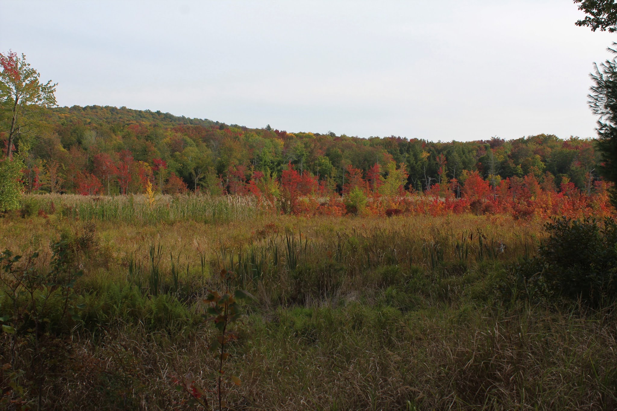
Did an easy after work walk at the Rensselaer Plateau Alliance's 436 acre Poestenkill Community Forest, which sits high up on the Rensselaer Plateau in the town of Poestenkill.  Elevations generally run between 1300 and 1600 feet at the Forest, meaning foliage should be moving along nicely.  Got started directly across Legenbauer Road from the parking area on the Little Beaver Bog Trail, where a fresh run of crushed stone made for nice walking.  The golden ferns trail side only enhanced the ambiance.

I wandered around on various trails, taking my time, enjoying the solitude.  At one point, I was even startled by an owl that flew down out of a nearby tree, but I wasn't quick enough to get his picture.  Here's a quiet stretch of the Moose Trail, which is the longest of all  the trails in the trail system here.

Many old woods roads and stone walls can be found throughout these woods such as Sugar Rock Road, pictured below, in the NE section of the property.

The highlight of the day was the view across Big Beaver Bog, where the foliage was dazzling. 
The trail offers only limited views, but there is one scenic overlook, directly over the heart of the bog.
The colors were so vivid that I decided to get down close to get a better look and I almost got dizzy from the sheer brilliance of all the red.
Back in the woods, a carpet of ferns blankets the forest floor along a section of the Hemlock Swamp Trail.
Take your best shot..with an acorn.
A nice and easy 3 miles total on a comfortably nice, cloudy fall afternoon. 
 

Tuesday, September 22, 2020

Stark Hills(Blue Mountain Wild Forest-Adirondacks)

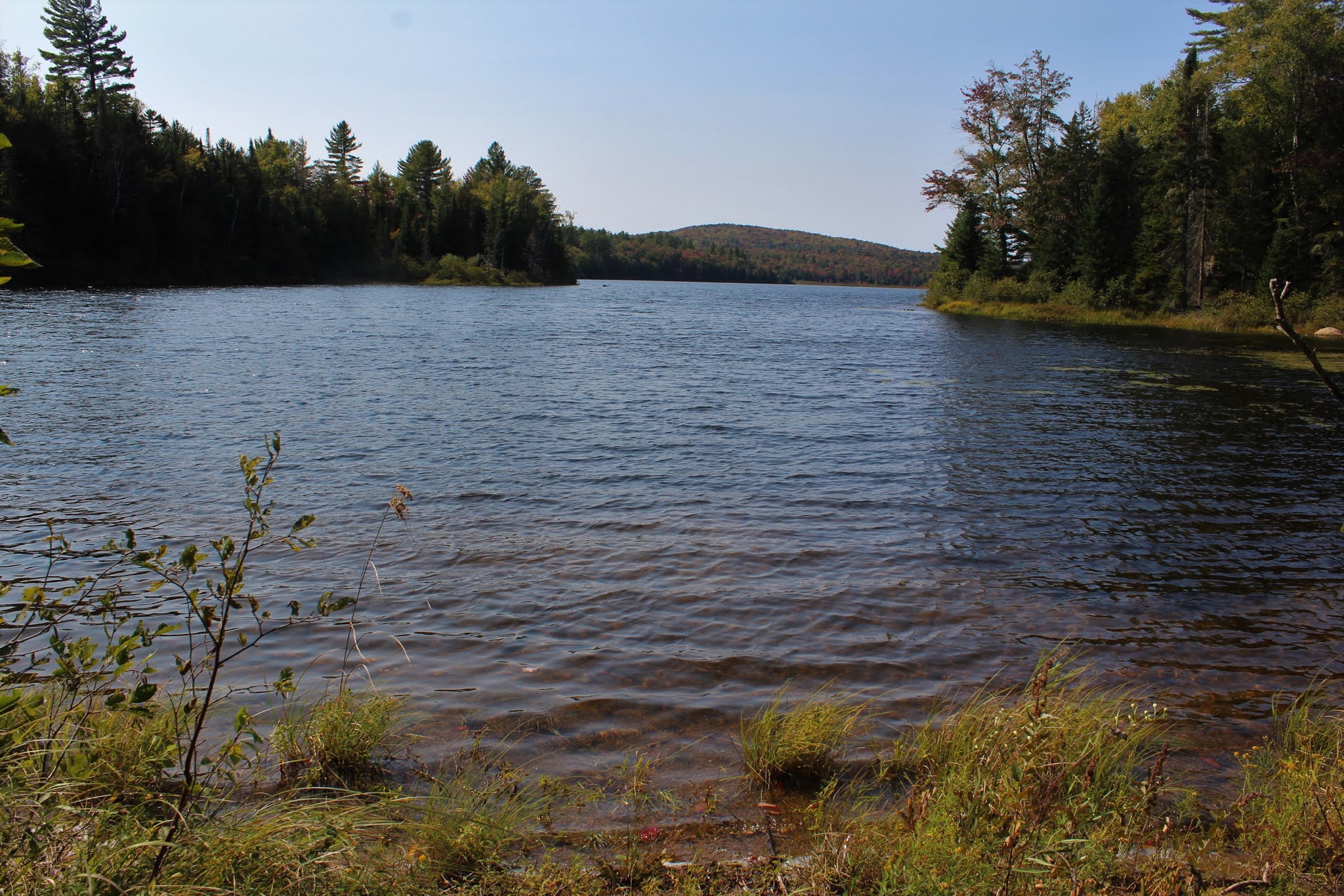
After my earlier hike of Moose Mountain in the Wilcox Lake Wild Forest, I wanted to head further north to see how far advanced the colors were up by Indian Lake.  One of the best foliage experiences I've had was from a couple years ago at Ledge Mountain, which sits NW of the hamlet of Indian Lake.  Today I wanted to visit part of the ridge that make up the Stark Hills, which are Ledge's northern neighbor.  Stark Hills are actually a cluster of peaks with the highest point rising to a modest 2283 feet.  The easiest access for Stark Hills is from the Rock River Trail which heads north from its trailhead off of Route 28.  Elevation at the trailhead was 1960 feet.

After my early morning bushwhack, it felt good to be on a trail for a bit.  I zipped along quite nicely covering ground quickly and before I knew it I was near Rock Lake.  A very short off trail excursion brought me down to the lake shore.  From this small cove on the east side of the lake, I enjoyed a nice view.
After enjoying the lake view, I headed back towards the trail but crossed over it and began my bushwhack ascent up towards the long ridge of south end of  the Stark Hills.  At first it was nice and easy, but soon the ascent got quite steep. 
From a set of steep ledges, I caught an early view SW towards Blue Ridge Mountain, with a corner of Rock Lake visible to the right.
From the same ledge, looking more south, with the large, sprawling wetland below.
These ledges were no joke.  A near vertical drop made good footing a must. 
I closely hugged the steep ledges, which were actually quite fun to explore.  There were many nooks and crannies to check out, each with halfway decent views. 
Although not the high spot of Stark Hills, the high spot on the long south ridge sits at 2273 feet, but is treed in.
While a lot of the hiking was fun, it wasn't all rainbows and butterflies.  There were several scratchy sections such as this to contend with.
From the far SE bump on the ridge, I found an open set of ledges, with the best views of all. 
West views.
South views from the ledge towards Ledge and Sawyer Mountains.  This made a perfect lunch spot, taking in the views and enjoying the serenity. 
On the descent, I had to backtrack a bit, dropping down SW carefully on the steep slopes.  Once down off the steepest section, I hit the first of two large beaver meadows.
Passing by the second beaver meadow as I continued SW.
Once beyond the two meadows, I had to slowly regain elevation, passing through an open forest on my way out. 

Out of nowhere, I hit the trail, almost literally at the trail register.  Signed out and got back to the car feeling great.  A fantastic, dare I say, perfect start to fall today.  Hiked 4 miles with 1300 feet of total elevation gain.  The route below. 

Red=Ascent    Blue=Descent


Moose Mountain(Wilcox Lake Wild Forest-Adirondacks)

Decided to head up into the Wilcox Lake Wild Forest in the Adirondacks to check out some early fall foliage on this first day of fall.  There are about a million Moose Mountain's in the Adks, but the one I would be hiking today is the one that can be found just south of Route 8 along the East Branch of the Sacandaga River.  There is no trail to these mountains so my goal was bushwhack to the east and west summits, which both appeared to offer up good views from open, burned over areas in my prior scouting of the peak.  I parked in a small, unmarked pull off on the shoulder of Route 8, just west of the western peak, elevation 1325 feet.  There was a definite chill in the air, with temps hovering around 40 as I crossed Route 8 and dove into the woods.

I began climbing instantly and within a scant 20 minutes I was near the open patches on the shoulder of the west summit.  As I pushed up through an open area I began getting good views right away.  Here was the first look I got, facing the multiple summits of Buckhorn Mountain to the NW.
Golden ferns and bright early foliage made the route up almost perfect.
I skirted around the steep slopes below the summit area, catching many solid views.  A window to the Buckhorns. 
I'm almost always amazed at not only how this section of the Adk always peaks first, but the amount of red that pops in this particular area.  Another great view NW towards the Buckhorns.
A great view SW above the East Branch valley.
After enjoying the west summit's views, I dropped SE down towards the col between the two peaks.  Much to my surprise, when I hit the col, I also hit the Georgia Creek Trail, which runs between the two summits.  I completely forgot about this trail so it really startled me when I saw trail markers.  Unfortunately, the trail was not going the direction I needed so I crossed over it and continued along.

A nice and easy ascent brought me over to the east summit, which sits at 2053 feet and just a tad higher than the west summit.  Both true summits are fully wooded and offer no views.
Mellow Yellow!  While many sections of the woods were still green, there were small sections that were near peak.

Dropping down to west edge of the summit, I could see some of the open rock that I was aiming for down below.  I carefully made my way over to the open rock, which at first only offered glimpses through the trees.  A little further descent bought me out to a wide open area of mostly open rock and incredible views.  From this vantage point, the fall foliage took it up a notch.  The wetland is a part of Georgia Creek, which sits at the foot of 2444 foot Georgia Mountain.
The colors were amazing!  Even better than I thought they'd be!!

Fire down below!  GeorgiaMountain towering above an unnamed ridge, with a fire red maple near the open rock slide.
One more view before I head down..this was a tough spot to drag myself away from.  The peaks near Speculator can be seen off in the distant west.
After finally tearing myself away from the views, I made a nice and easy descent off the mountain, even picking up a game path for a bit on my way out.  Once back to the car, I dropped down below the parking area to check out the East Branch, which seemed to have more rock than water in it.  Some color was beginning to pop down here as well.
A wonderful, fun packed little adventure for part one of the day.  3.5 miles RT, with over 1200 feet of ascent.  

Today's Route below.  Red=Ascent   Blue=Descent