Search This Blog

Monday, March 29, 2021

First and Second Brother Mountains(First Brother Primitive Area/Pharoah Lake Wilderness-Adirondacks)

 The Three Brothers are a set of three peaks that rise up above Brant Lake to the northeast and can be accessed from either the First or Third Brother depending on your approach.  Having previously hiked Third Brother last year, my game plan today was to hike up First and Second Brother from state land along Pallisades Road.  Parking can be a bit of a challenge as there is no formal parking area, but luckily all the snow has melted so I was able to park my car along the shoulder of the road. There is an informal trail that leaves Pallisades Road(elevation 850 feet) and heads generally east up the spine of First Brother's west ridge, so I hopped onto it.  After starting in a dark evergreen forest, the trail begins to climb steeply, quickly transitioning into a much more open hardwood forest with screened views to the south.

A biting NW wind and temps in the upper 30's had it feeling a bit wintry, although almost all the snow and ice has disappeared. 

The first knob on the way to the First Brother is sometimes called "Little Sister" or "West Brother".  It is a nice and open little bump with pleasant views to the west.  Gore Mountain's ski slopes can be seen in the distance, with Brant Lake in the foreground.
The state land becomes just a sliver on its way towards the summit, but there are good views of Brant Lake to enjoy.
The route up First Brother is quite frustrating, as there are numerous open views that sit just off state land.  Thankfully, the wooded 1667 foot summit is on public land, however.  Through the trees, Second Brother can just be made out.
Just off the summit, in a shaded area, I spotted a fresh bit of snow.  As I mentioned, signs of winter were few and far between on these peaks.
A nice and easy descent off First Brother soon lead me to the west slopes of Second Brother, where I continued following a hit and miss red blazed unofficial trail.
As I climbed Second Brother, state land begins to finally open up, affording me the chance to do a bit more exploring.  There certainly aren't as many views on this peak as First Brother, but I did find some small view points.
The very pleasant woods on my up Second Brother.
Arriving at the wooded 1854 foot summit of Second Brother, which is marked with a red stake.
Just south of the true summit sits a false summit that looked sort of open, so I thought I'd give it a look.  From here, at the very edge of state land I found fantastic views.  A look east, with Route 8 threading its way through the mountains.
South facing views.  There was a ton of open rock just below here, which would've offered up incredible views...but it was all on private land.
I continued my bushwhack west below the summit area and managed to find an awesome view back towards First Brother and Brant Lake. 
A zoom view down towards Brant Lake.
From the same vantage point, looking out over First Brother to the NW.
The cold winds kept me moving along on my return route back to the car.  Hiked just over 4 miles round trip with 1450 feet of total ascent.
Today's route below.  Red=Route in    Blue=Return route


Rogers Rock(Rogers Rock State Campground-Adirondacks)

Rogers Rock is not only a very popular State campground along the west shore of Lake George, but also provides access to spectacular views from the tops of three separate summit bumps that rise far up above the lake.  Although in the summer months there is a entrance fee, during the off-season the gate is kept open and you can hike for free. An old trail, unmaintained but heavily used and blazed(and at times flagged)in orange, starts from campsite 210, entering the woods heading NE.  There is no signage to indicate where the trail starts, but it can easily be picked out from the backside of campsite 210, elevation 440 feet.

 
Within just a few minutes the "trail" arrives at the foot of the western cliffs of the mountain, with   large boulders littering the slopes above.

The trail turns east in just a moment, gaining elevation quickly.  While the climb is short, it is very steep and at times wet.  Before you know it, there are screened views already opening up towards Lake George.
 
The views aren't just towards the lake, but wide open to the west as well!  Looking out towards the peaks surrounding Route 8 between Hague and Brant Lake.


Once atop the first summit bump, there are numerous ledges, each with incredible views of Lake George.  These views are not to be missed!!!  South facing views spreading over Anthony's Nose and all the way down towards Black Mountain on the distant east shoreline. 
From the ledges, looking SE across the lake at Record Hill and Anthony's Nose.

 I can't stress this enough if anyone is bringing small kids..these ledges are quite dangerous and the drop off is no joke.


Well back from the ledges and back into the woods, I found this small but pretty vernal pond, which seemed to be teeming with life.


From a spot just off the old trail, I was able to see the open rock on the second summit bump, just ahead.

While there are decent views on the second bump, they don't come close to comparing to the first bump.  I did enjoy a slightly different angle over the lake, still looking south.
A very easy bushwhack a few yards off the trail brought me up to the 1027 foot high point,which was fully wooded.
From the second bump,  looking back at the first summit bump and its open cliffs.

The informal trail eventually leads to a third summit bump, which has amazing north facing views towards Cooks Mountain and the north end of Lake George.  Wow!

 After hitting all three bumps, I turned back, retracing my steps, and enjoying the wonderful views along the way.

There are so many great views on this short hike that you are almost overwhelmed.  To add to that, I had the entire mountain to myself.  If it wasn't for a strong, cold wind I could've stayed up here forever.
Hiked about 3.3 miles total a touch over 800 feet of ascent.  A pretty easy hike with a tremendous amount of bang for the buck!!!

Today's route below.


Friday, March 26, 2021

Taghkanic Lake State Park(Columbia County, NY)

With potential severe weather north of Albany in the forecast, I decided to head south after work this afternoon to visit the 1569 acre Taghkanic Lake State Park located in southern Columbia County and just east off the Taconic State Parkway.  I had previously been here many years ago on a very cold winter day, so suffice to say I was happy to arrive today with temperatures soaring through the mid to upper 70's!!  I parked near the public beach along the west side of the lake(elevation 650 feet) and headed south on the white blazed Lake View Trail, passing by the rental cabins , enjoying great lake views nearly the entire way.

At the very south end of the lake there is a large flooded area that pushes the trail out to a rough dirt road.  Even here the scenery is quite nice.

Once back in the woods, I decided to leave the trail altogether and dive into the woods, bushwhacking east towards a small unnamed peak which is also the high point in the park.  The woods were wide open and nearly 100% deciduous making for very easy going.

Near the 935 foot summit, I spotted a very well built stone wall on a steep slope almost at the very south edge of public land. 

As mentioned, the woods were very open and easy to navigate....a bushwhacker's paradise!  Arriving at the open area atop the peak, elevation 935 feet.

I wandered around the summit area in search of views and found one small view to the east.

After enjoying the summit, I continued my bushwhack NW towards another peak, just slightly lower but still on state land.  A slight descent and re-climb soon found me atop this wooded 885 foot peak.


Just below this summit, on the northwest facing slopes above the lake, I found some nice ledges with screened views over the water and towards the distant Catskills on the horizon.  The wind was really picking up now, gusting quite strongly.

A short but steep drop brought me back down to the familiar white blazes of the Lake View Trail.  To the north I could now see the main park offices and public beach across the choppy waters.
I followed the Lake View Trail east, basically hugging the south shore of the lake, only leaving it for a few minutes to check out the orange blazes of the Winter Trail.  Back down on the white trail, crossing over a small stream near the SE end of the lake.
 

I decided to check out a couple of the trails on the east side of the lake, but there wasn't anything too much to see so I headed back down towards the Lake View Trail.

The trail along the east side of the lake skirts a very large wetland, accompanied by a symphony of spring peepers.
Once on the north end of the lake, I basically headed back west towards the car, hugging the shore again.  Although the temperature was still quite warm, a stiff wind kept me moving.

Hiked about 6.3 miles total, with 1200 feet of combined ascent.  I had a really great day, but unfortunately did have to pick several ticks off of me.  I guess it can't be all good!

Today's route below.   Red=Trail     Blue=Bushwhack


Monday, March 22, 2021

Eddy Mountain(Lake George Wild Forest-Adirondacks)

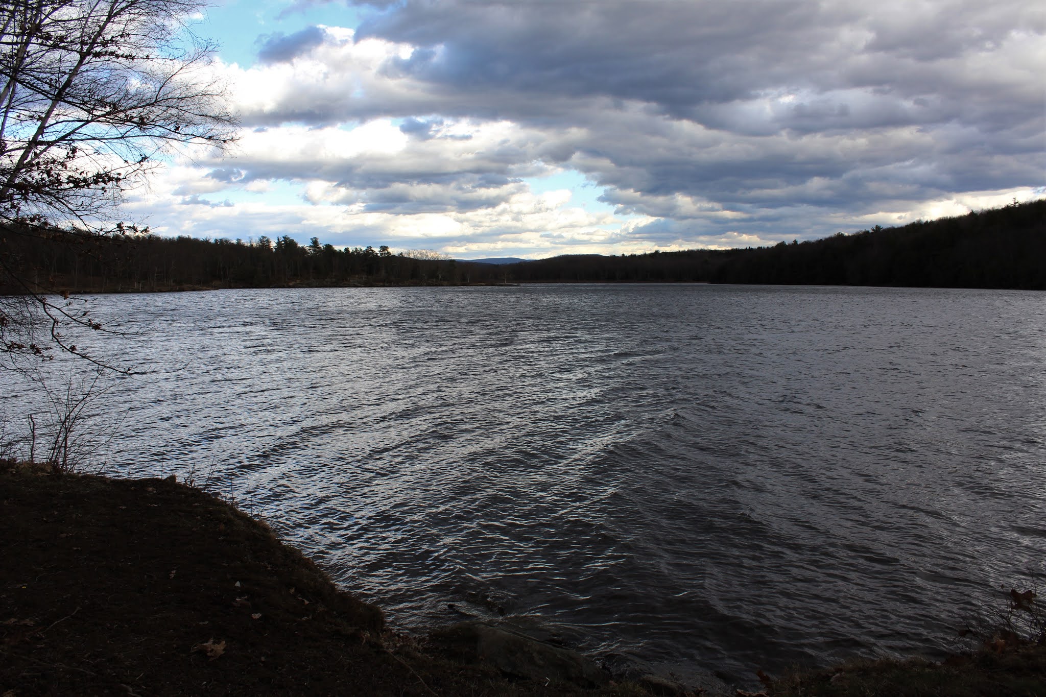
Spring has really sprung this week, and I was glad to finally get out and enjoy some of it!  Wanted to check out Eddy Mountain and its NW sub peak(unnamed) along the east side of the Hudson River near Lake Luzerne today.  With the calendar still in March, and temps climbing up and through the 50's and lower 60's, I wasn't really sure what kind of road or hiking conditions to expect.  I decided to park at an unmarked foot path, elevation just under 600 feet, that sits basically west of Eddy Mountain's south slopes(where I planned to end my hike) and then walk River Road north instead of driving it, towards the Bear Slides trail.  A look north along the shores of the tranquil Hudson River just below River Road near the start of my hike.

River Road conditions varied from muddy with deep ruts and pot holes to mostly dry.  Beyond the maintained section of road, the conditions deteriorated to snow and ice all the way to the start of Bear Slides trail.  Within just a few moments on the trail, and quickly gaining elevation, the snow and ice was replaced by bare ground.
As the trail continues gaining elevation NE into a dark, conifer forest, the snow and ice returned in full force.  I thought about putting on my spikes, but resisted.  The Bear Slides were partly frozen but still pretty..and running strong.
Bear Slides from above. 
Just above where the creek splits, I found a nice and easy place to cross and began my bushwhack south up the steep, northern slopes of the unnamed peak.
The climb was quite steep, but pretty short and straightforward.  As I hit the summit ridge, the woods changed to wide open hardwoods and I could feel a noticeable jump in the temperature.  After hitting the wooded 1345 foot top, I continued west, losing a bit of elevation, but found some very nice viewpoints.  A northwest view towards Baldhead and Moose.
My favorite spot on this small peak, was a wide open SW facing ledge towards the Hudson River valley.
West views towards Bear Mountain across the Hudson.
With 100% sun and wide open patches of woods, I really took my time, enjoying the entire summit area of this little gem.  Near the south slopes, I found this nice look towards my next destination, neighboring Eddy Mountain, with Thomas Mountain poking out behind.
A short, steep drop south brought me into the dark, cold and wintry saddle between the peaks.  It really was amazing to see the stark contrast in conditions in such a short distance apart.
A nice and easy ascent up the north slopes of Eddy, brought me to the wooded 1352 foot summit.
From the summit, I dropped slightly, heading south through mostly open woods and hugging the steep west facing slopes.  Soon I came to a wide open viewpoint, complete with all sorts of decorations and a weathered, torn flag flowing in the breeze.
The vista from here is quite nice, spreading out far and wide to the west.  Hadley and Roundtop make up the wintry ridge on the distant horizon, with Bryan Mountain rising above the Hudson in front.
Same viewpoint, looking NW with Bear being the most prominent peak.
I continued south along Eddy's ridge to near vertical slopes that make up the south end of the mountain.  There are several good viewpoints along these south facing slopes.  This is a look south at a bend in the Hudson River and the lower slopes of Coman Mountain coming down to meet the river.
Just before my steep descent I found another open ledge with a similar view to the one above.  I basked in the full sun here for several minutes, enjoying the great views.  Sure feels great to be outside in March without a jacket, enjoying a south breeze.
When it was time to descend the mountain, things got a little tricky.  The south slopes on Eddy are no joke, and it was a slow and meticulous drop, all while enjoying SE views like this.
Nearing the base of the rocky, vertical ledges.
After the tough drop off the mountain, it was a nice and easy bushwhack over to a woods road, which headed west back to River Road and my waiting car.  In the shaded conifers down low, there was still several inches of snow that mas turning to mash potatoes under the weight of each step I took.
After a little more than half a mile, I quickly arrived back at the car feeling great.  Didn't see another soul the entire hike.  Just under 5 miles RT, with around1200 feet of ascent.