Search This Blog

Tuesday, January 26, 2021

Mahanna Cobble via Bosquet Ski Area(Berkshires)

With snow in the forecast for this afternoon, I decided to head east just over the state line into Massachusetts to check out the Berkshire Natural Resources Council's newly constructed trail from Bosquet Ski Area up to 1889 foot Mahanna Cobble, which is the northern summit of Lenox Mountain.  Although hikers have always had access to the explore the ski slopes, they were never allowed during the winter ski season.  All of this changed recently when the BNRC partnered with Mill Town to build a hiking trail from the ski area up to the top of the Cobble, with minimal impact to the ski operations.  

From the parking area(elevation 1125 feet), head over to "Tube Town", where a trail map and signage will point you in the right direction.  Blue markers and signage aide you as the trail crosses over ski slopes as well as woodland areas on its way to BNRC property.  I chose to bare boot it because there were only a few inches of snow and it was all very well packed and supportive.

After about 6/10 of a mile, the trail comes to a BNRC kiosk and continues SW, slowly gaining elevation on the east slopes of the mountain. There are screened views to the east through much of this part of the hike.

Do I have a witness??
The trail switchbacks a couple of times just below the top of Mahanna Cobble, with more filtered views to the east.
From atop Mahanna Cobble, there are very nice, open views to the south where Kennedy Park and Yokun Ridge make up the most prominent ridges.  "George's Bench" makes a perfect spot to stop and rest, while soaking in the views.
From Mahanna Cobble, there some options.  You can either hike back on the trail you just came on or continue either north or south along Yokun Ridge.  I chose to head north towards the top of Bosquet's ski slopes.  This part of trail, while still used, showed much less foot traffic.
There are a pair of towers atop the ski slopes, set back in the woods a bit.  I believe one is a cell tower and the other bring a radio tower.
Just a few yards past the towers, the woods open up to a wide open, sprawling view from atop Bosquet's ski slopes.
The view is pretty remarkable from up here.  To the far left is the Taconic ridge, with the Greylock Range front and center.  Much of the city of Pittsfield can be seen sprawling in the valley below. 
After enjoying the views, I headed back to the "Secret Trail", which briefly lead me through the woods and back to the Mahanna Cobble Trail.  It was a nice and easy return route from there.  Hiked about 3.2 miles RT with 850 feet of ascent. 

This morning's route below.     Red=Ascent         Blue=return(descent)


Saturday, January 23, 2021

Hand Hollow State Forest(New Lebanon, Columbia County)

Did a little exploring at Hand Hollow State Forest in the Columbia County woods after work this afternoon.  The State Forest, located in the town of New Lebanon, consists of 518 acres and is split north and south by County Route 34.  A marked trail to a 10 acre pond can be found crossing the road and heading south, while there are no marked or maintained trails to the north.  My ambition today was to bushwhack around the northern part of the State Forest, checking out the woods and hitting a pair of small unnamed peaks.  Although the skies were blue, there was a definite bite in the air, with wind chills hovering around 0 as I set out from the marked parking area along County Route 34(elevation 870 feet).

From the parking area, I quickly picked up an informal hunters path that crosses the meadow and then entered a dark, hemlock forest.  There was a remarkable amount of blue, pink and red paint on many trees throughout these woods.  Not sure of any specific meaning but it was literally everywhere.
Most of this land was farmed a century ago, so it was no surprise that I crossed over an old stone wall, as well as spotting several others along the way.  Only about 2 or 3 inches of crusty snow covered the ground making for pretty nice bare boot hiking.

The public land forced me in a general NE direction, slowly gaining elevation and crossing over a tiny drainage stream in between ridges.

The woods were remarkably open as I continued meandering my way NE, when suddenly I came across a very intact woods road as well as an.....abandoned car?
Sure enough, it was a Subaru hatchback that someone had apparently gotten stuck.  This was a first for me..finding an abandoned car in the middle of the woods.  These are the reasons I love to explore.
Beyond the car, I followed the woods road for a short distance NE before leaving it for yet another, lesser woods road, which headed due north before eventually disappearing. From that point, I simply continued heading north, bushwhacking right up the steepest slopes I saw all day.
On my way up, there were a ton of coyote and deer tracks in the snow.  It's always so fascinating to see the footprints and animal activity in the winter woods.  The climb was fairly straightforward and uneventful, as I soon arrived at the wooded 1364 foot peak.  This would mark the highest spot I hit all day. 
Again, private land forced me in a direction I didn't necessarily want to go, heading south off the summit and momentarily leaving the main ridge.  As soon as I saw the state land open back up I headed east up the slopes of the next ridge.  Once up high, I cheated to the steeper north slopes in hopes of a possible view. 
Unfortunately, the trees blocked any substantial views, but there were nice filtered views all around.

Approaching the next high spot on the ridge as well as my next destination.

Bon apetit?

Just below the summit, I hit another remarkably well preserved stone wall.

There were a couple of similar looking high spots but this appeared to be the true 1348 foot summit, which was completely wooded.

I took my time on the return hike heading basically west towards the setting sun, soaking in the solitude.  A sliver of the late afternoon sun poking through the trees and splashing light on a tributary of Hollow Brook was the highlight of the day for me.  

Hiked about 4 miles total with over 900 feet of combined ascent.  Today's rough route below.


Wednesday, January 20, 2021

Beebe Hill State Forest-North(Canaan, Columbia County-Taconics)

Headed east after work this afternoon to do some exploring in the far northern part of the 2018 acre Beebe Hill State Forest near the NY/ Mass state line.   Most folks are well aware of the fire tower atop Beebe Hill, but what many don't realize is that there are several other small peaks that few hikers ever see in these woods.  My goal for today was to park at the closed Sunoco gas station just off the B3 exit in Canaan, and bushwhack my way up to an unnamed 1785 foot high point just north of No Bottom Pond.  As I set out(elevation 940 feet), I headed north on an unplowed old road, which parallels I-90, and provides access to state land about 3/10 of a mile away. This was certainly the worst part of the hike, with rushing traffic just 20 yards away and a heavy snow squall bearing down on me.  In summer, this part of the road could easily be driven, cutting off some time from the hike.

Once I left the paved road, I picked up a good 4 wheel drive road that leads up to a State Forest parking area.  From the parking area, I followed a herd path, then a woods road along a thin strip of state land that continues northwest, closely hugging the interstate.  A short distance in, I came to some kind of an old quarry with views northeast across the interstate towards Deane Hill.(or even possibly an area of earth and stone moved to make room when they built the interstate)
Just beyond the quarry, my true bushwhack began.  The slopes were quite steep and public land didn't go straight up so I sort of had to angle my way up., heading generally SW.
I did my best to stay on state land, with several annoying ups and downs on the rocky slopes.
The higher I climbed, I began to be rewarded with screened views to the NW, with I-90 cutting through the rolling hills.
Although there was a crusty 3 or 4 inches of snow on the ground and a fresh coating of an inch or two on top, these conditions didn't slow me down at all.  As I made my way up the steep slopes, the skies actually began to clear out as well.
At just over 1600 feet, I momentarily left the hardwoods behind, heading through a dark, coniferous ridge.  This extremely large boulder caught my attention here, seeming so out of place. 
Once over 1600 feet, the terrain leveled out nicely, with just a small rise through wide open hardwoods again. Suddenly, out of nowhere..I saw light!   After countless cloudy days, the sun broke through, brightening up the winter woods! 
I did my best to stay up on the ridge, heading SW through the open woods.  Just when I thought I had it easy, about 1/3 of a mile from the high point, I hit a large area of mountain laurel.  Even during the dead of winter these can still be a royal pain. 
Lucky for me, I easily side stepped the mountain laurel and stumbled upon a very good woods road, heading right towards the high point(and the sun). I followed a pair of coyote tracks on this road to within less than 1/10 of a mile of the high spot.
I left the woods road and whacked my way up to the nondescript 1785 foot high spot I was shooting for.  This spot, although just an unnamed bump, is actually higher than Beebe Hill itself. 
On my return, I made good time following the woods road which I had somehow missed on the way up.  I left it again, however, down around 1600 feet in search of potential views from the steep NW slopes of the ridge.
Try as I may, I simply couldn't find a clear view from up high.  The through the trees views across I-90 were quite good however! 
On the descent, I decided to go check out the pond in the far NW corner of the state forest, right beside the interstate.  Unfortunately, early sunset and thick prickers were working against me.  I did get down to the frozen, snow covered shore, but with darkness setting in, I quickly moved on, fighting my way through the scratchy woods.  Arrived back at the car just after dark and feeling a little exhausted.  Hiked nearly 5.5 miles RT, with over 1400 feet of combined ascent.  The rough terrain made this "easy" hike much tougher than I thought it might be.  

Rough route below.  Blue=Ascent   Red=Descent


Friday, January 15, 2021

Hannacroix Ravine(Berne/ New Scotland, Albany County)

Took advantage of a small window of time I had this afternoon to visit the Nature Conservancy's 415 acre Hannacroix Ravine located on the New Scotland/ Berne town line off of Cass Hill Road in the Helderbergs.  I was a bit surprised that there was several inches of snow on the ground up here(elevation 1220 feet to start), but still not enough to warrant snowshoes.  I headed out into the dark coniferous woods following the orange blazes south, on yet another overcast, dreary day.  

The toughest park of the entire hike is the crossing over Hannacroix Creek.  On any given occasion, you may encounter slick rocks, a swift current, or a thin layer of snow and ice to go with freezing water.  The latter proved to be the issue today.
The creek crossing was a little tricky, but I took my time, easily negotiating a safe passage.
Once across the creek, the trail narrows its way west through an old hemlock forest, before turning back north.
Throughout the preserve, the trail crosses over several small streams that drain the slopes of the ravine. 
The current snow pack on the ground, coupled with an incoming winter storm's clouds gave the woods a very black and white feeling.

Soon the trail jogs uphill out of the ravine, picking up an old road.  Stone walls line this section with filtered views across the ravine to the east.
The old roadbed continues north, passing by a private backyard and eventually back to Cass Hill Road.  From there, it was a short 2/10 of a mile road walk back to the parking lot.  Hiked just under 2.5 miles total with 400 feet of ascent.

For more information, visit https://www.nature.org/en-us/get-involved/how-to-help/places-we-protect/eny-hannacroix-ravine/


Tuesday, January 12, 2021

Round Hill & East Mountain(Clarence Fahnestock State Park)

Decided to head south to visit 14,337 acre Clarence Fahnestock State Park in northern Putnam County this morning.  This would be my first visit to this State Park, so I wanted to check out Round Hill and East Mountain, the two most prominent peaks in the park.  To start I headed to Hubbard Lodge, located just north of Route 301 and east of Route 9 in Cold Spring, elevation 420 feet.


The white blazed trail sets out east, passing by the lodge and heading down to School Mountain Road, an old, abandoned farm road .  Within just a few moments the old road crosses two well crafted footbridges over pretty Clove Creek, which is wide and slow moving through this area.

Beyond the creek crossings,the old road continues east, entering a hardwood forest and dropping into a deep draw between the peaks.
Yellow blazes and crumbling stone pillars mark the entrance to the old Hubbard Mansion, which leaves School Mountain Road to the north.
Just beyond the pillars, I left School Mountain Road and picked up the blue blazes of the Fahnestock Trail, which head right following along one of the branches of wintry Clove Creek.

The trail stays level for a bit, heading toward the southern end of Round Hill's steep slopes, before finally beginning a steep climb up the southern tip of the peak.

After a steep push up through the rocky slopes, a small, somewhat grown in view to the SW appears from a ledge.  The junctions of Route 9 and 301 can be seen down in the valley below.
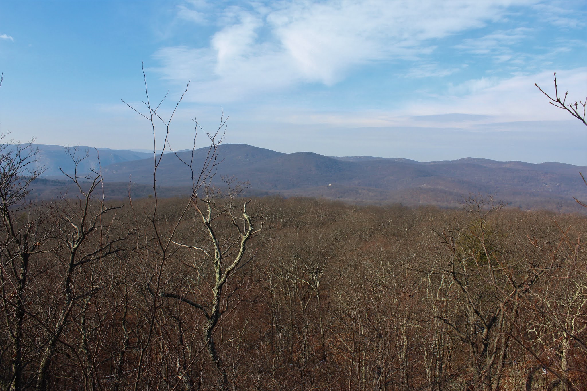
Once up on the ridge, the walking is nice and mellow, with through the trees views all around. 
The trail slowly gains elevation, passing through wide open hardwoods and laced with old stone walls.

After a benign walk up the ridge, the trail finally becomes steep once again on its way up to the summit.  Just below Round Hill's summit, I found the best views of the day looking mostly west.

Crows Nest, North Point and Storm King Mountain across the Hudson can easily be seen from here, as well as Bull Hill, rising prominently above the east side of the river.
Looking up at Round Hill's summit from the view spot.
Just a few yards off trail sits the 1090 foot summit of Round Hill, easily accessed by a small herd path.
From a small window near the summit, I caught this nice east facing view towards Route 301 and the rolling peaks in the of Fahnestock State Park. 
After dropping down off the summit and then passing over the green blazed Round Hill By-Pass, the trail continues basically east undulating along the ridge.
While no grand views can be found on this ridge, there are decent "almost" views to be had.

After a pleasant but fairly uneventful ridge walk, the trail finally begins to descend a bit, coming to a junction with the yellow blazed Perkins Trail.  This trail heads north/ northwest dropping down along a winding, fast flowing stream.

Near the base of the deep drop, the Perkins Trail meets back up with the white blazes of School Mountain Road.  From here, an old abandoned farm house can be seen in the woods, looking oddly out of place.
With the old house in site, the red blazes of the East Mountain Loop Trail head right, passing between well built stone walls and old cellar holes.
The farm house is in rough condition and doesn't look very stable anymore.  Not sure of the exact history of the farmhouse but it is certainly a very interesting find.
This particular stretch of the hike along the East Mountain Loop is literally laced with stone walls, old foundations and many other signs of the past. 
Would love to know the history of this area along the trail.  There are many, many fascinating remnants to check out.  While seemingly away from the rest of the world today, these woods were once bustling with farming activity in the not so distant past.
The East Mountain Trail heads north then bends west, climbing steadily but not steeply up the slopes of the mountain.  Just a couple yards off trail sits the 1070 foot, nondescript summit.
After some poking around just below the summit, I was able to find some decent views from the steep west facing slopes towards Schofield Ridge and Fishkill Ridge.
Leaving the views up high, I began my descent  along the red blazed trail along more stone walls, with Round Hill's profile rising above through the trees.

Back down off the slopes of East Mountain, I picked up the familiar white blazes of School Mountain Road once again.

One of several crossings over babbling Clove Creek.


School Mountain Road makes for a very pleasant, easy walk along an old abandoned farm road.  I followed this west back towards where I had left the road near the start of the hike by the Hubbard Mansion pillars and eventually Hubbard Ledge and my car.

Hiked just over 7.5 miles total, with over 1700 feet of ascent along the way.  Was really shocked to only see two other people the entire day.  A nice winter day with minimal snow or ice to speak of.