Search This Blog

Thursday, October 29, 2020

Robert Ingalls Preserve(Stephentown, Rensselaer County)

Went out for a short, local early morning walk in an attempt to beat the rain coming in.  Cool, damp woods made for a pleasant but hasty one mile loop, with the babbling sounds of Black Brook singing a quiet melody.


Wednesday, October 28, 2020

Mount Pisgah(Mount Pisgah State Forest-Catskills)

Hasn't been a very nice week in the weather department around here, but with a forecast for clearing afternoon skies today, I thought I'd do a small after work hike and hope for the best.  Headed down to the northern fringes of the Catskills to hike NE Richmond Mtn, Richtymer Peak, and Mount Pisgah, all peaks that I had climbed before but with a slightly different twist. I approached the mountains from the south, heading up Mount Pisgah Road before then turning onto a unmarked DEC service road which becomes quite rough as it climbs quite high up the slopes between Richtmyer and Pisgah.  There are two areas to potentially start this hike, making it a full loop.  I chose not to drive all the way up to the high lot, with sits at over 2700 feet, due to my uncertainty about the road conditions.  Instead I parked on the shoulder of the service road near the spot where an old carriage road(unmarked) comes down off Pisgah's slopes.  From this spot, elevation 2450 feet, I walked the rest of the road heading generally west before hitting the upper lot.  At the upper circular parking area, an almost unnoticeable yellow blazed trail heads into a hardwood forest, climbing steadily on an old woods road. 

Instead of sticking to the woods road, I simply bushwhacked straight up towards NE Richmond's high spot through open woods.  My hopes of clearing weather were quickly dashed, as I made my way up over 3000 feet onto the Long Path atop the ridge, where I hit a wall of fog.
3120 foot NE Richmond's view spot...where a nice little view can be had....just not today.
From NE Richmond I followed the Long Path heading NE through increasingly foggy conditions.  Seemed almost fitting that this close to Halloween, I'd encounter these "haunting" woods.
In a low spot between NE Richmond and Richtmyer, I hit a woods road that was in pretty good condition.  This is a look through the eerie woods, where the woods road continues north.
Just a short climb up from the low spot, I hit the wooded, nondescript high spot on Richtmyer Peak, which sits just off trail.
Dropping down into the col between Richtmyer and Pisgah, where some green still clung to the ferns in this protected area between the peaks. 
From the col, I continued east on the trail, soon hitting the ominous, conifer forest near Pisgah's summit. 
A steep ascent through the dark conifers leads straight up towards the summit. 
Arriving at the 2912 foot summit of Pisgah, where a benchmark can be found at a bend in the trail.  From the summit benchmark, the Long Path continues east and an unmarked trail stays right, heading south.  This unmarked trail is actually an old carriage road, and that is the way I was heading.
Although it's hard to tell just by looking, there is a lot of history on this mountain.  A summit hotel graced these woods back in the 1880's and a carriage road made the top of the mountain accessible to guests.  Very little remains from the old hotel, which burned down only ten years after opening, but there are stone foundations and an old spring that provided water to the guests and horses at the hotel.  Another neat little spot is Inscribed Rock, located almost directly across from the spring.  Hotel guests, as well as many others through the years have carved their initials into this rock. 
After enjoying the summit area, I began a steady descent down the old carriage road, which heads south, then west, back towards the service road and my waiting car.  Suddenly, almost like turning a light switch on, the sun fully emerged as I descended down the old unmarked carriage road.  Too little too late at that point, but the fog actually enhanced the experience for me anyway.

Hiked just under 4 miles total, with 1050 feet of ascent along the way.

As I headed home, I took a moment to stop on Cunningham Road to enjoy a great view back at Mount Pisgah to the west, and a tidy little Catskill farm at its foot.


Wednesday, October 21, 2020

Vernooy Kill Falls & Cherrytown Ridge(Sundown Wild Forest-Catskills)

 Headed south today to do a little exploring in the Sundown Wild Forest, where I figured the foliage would be holding on a bit longer.  My goal for the day was to hike to Vernooy Kill Falls from the Upper Cherrytown Road trailhead, then bushwhack south up Cherrytown Ridge, where it looked like there may be some views.  I was stunned to see no other cars in the lot when I arrived, but I guess the clouds and light drizzle kept folks away.  The forecast for the day was for clouds and fog early to be replaced by clearing skies and increasing sunshine along with mild temps, so I headed out optimistically.   Elevation at the trailhead is 1225 feet, where I crossed the road and headed NW into a damp, mixed forest. 

Just a quarter mile into the hike, a nice footbridge crosses a tiny tributary stream.  From there it is a nice and steady ascent for another 1.5 miles NW towards the falls.
Welcome to Upper Cherrytown!
The rushing sounds of falling water could easily be heard now, so I rushed on over to check out the Vernooy Kill Falls.  From a footbridge, the views of the main falls are very nice.  There are actually a series of falls that drop over 60 feet both above and below the bridge.
Looking back upstream at the footbridge and falls. 

Just downstream from the bridge, located along the east side of the creek are the remains of the"Cornelius" Vernooey mills, which operated from the early 1700s until 1809.
Upper falls on the Vernooy Kill.
I explored the creek both upstream and downstream a bit, where I actually bumped into a couple of guys camping just north of the falls.  This is a nice look at the creek just upstream from the falls. 
After enjoying the falls and surrounding area, I headed back up the trail the way I came, hitting a height of land, where I picked up a woods road going south up Cherrytown Ridge.  The woods road was very good at first, but soon became a bit rougher, then turned into a foot path, and then split off in several different directions.  Some of the paths were easy to follow, while others seemed to go nowhere.  As I gained elevation on the ridge, the clouds and mist only seemed to increase.  I found several large clearings up on the ridge, but the clouds didn't seem to want to budge.

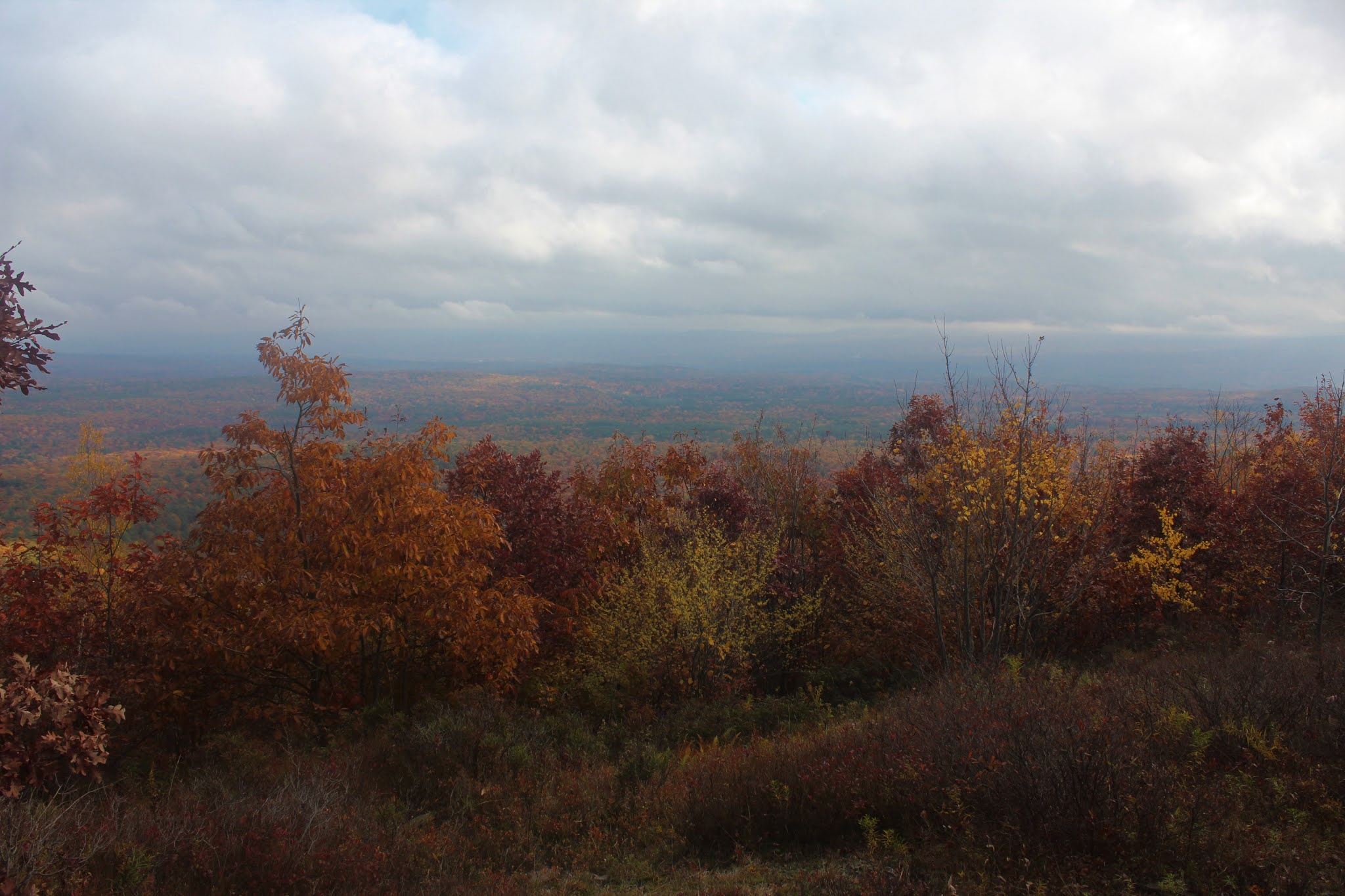
Not willing to give up just yet, I continued south up the ridge, nearing 2000 feet, and prayed for the clouds to move out.  Almost on cue, as I circled over to some steep east facing ledges, the skies cleared out just enough to allow a colorful view out over the Rondout and Wallkill Valley's to the east.

  Looking east straight down towards someone's house along Upper Cherrytown Road.

A few yards up from the steep slopes, there was a bit of a clearing that provided a wider perspective to the east.


More of a SE view from the same clearing, where the clouds seemed to be just a bit thicker.

After checking out the east facing views, I headed over the top of the ridge and down slightly to the west, where I hit a very large clearing and wide open views.  From here, I enjoyed this very unique view to the NW, where Bangle Hill, Samson Mountain(the high spot on the ridge) and Spencer's Ledge can be seen.
Directly to the west, the view takes in a slightly lower unnamed Cherrytown Ridge, with the multiple summits of East Mountain just beyond. 
SW facing views towards the south end of the unnamed ridge just west of Cherrytown, with East Mountain just beyond.

After enjoying the nice west and north facing views, I headed back over the ridge, continuing over to the steep east slopes.  From a small framed opening in the trees, I did manage to find a neat view NE towards the lower slopes of Mombaccus and High Point, as well as a sliver of the Ashokan Reservoir poking out.
Instead of following the ridge north all the way back, I decided to simply dip down into the woods, descending steeply to the NE.  For the most part, the woods were open, with just a small tangle of mountain laurel here and there.
Once back on the trail, I hummed right along, making it out in no time at all.  I was a bit surprised to see half a dozen vehicles in the parking lot when I arrived at my car.
Hiked a bit over 5 miles RT with 1260 feet of ascent along the way.  A mild, but damp day in a gorgeous little corner of the Catskills.  Today's rough route below.  Red=Trail  Blue=Bushwhack


As always, one of my favorite parts of hiking in the Catskills, is the drive to and from.  Today was no exception, as I enjoyed this unique view of Ashokan High Point and Little High Point from the south at a bend on Samsonville-Kerhonksen Road.


Saturday, October 17, 2020

Garfield Mountain(Slide Mountain Wilderness-Catskills)

With half a day still available to hike, I decided to check out 2582 foot Garfield Mountain-no not the cat-the mountain.  Garfield doesn't really get much attention, and is seemingly just a far extension of Panther Mountain's long NE ridge.  There is no trail going up Garfield but there are several different access points that you could pick out a route up with.  I chose to start from Muddy Brook Road, where state land provides a route up towards Garfield's east ridge.  Elevation to start was down at 1230 feet, so there would be some nice climbing to get up the mountain.  The ascent began almost immediately, heading north through open hardwoods. 

State land brings you around the steep east slopes below the ridge, and the footing can get quite tricky in spots.  With the steep slopes come surprisingly good views too, though!  At just under 1800 feet, I found some really good peeks down towards the Esopus Creek and Phoenicia.  Tremper Mountain is in the distance, with Romer's north ridge on the right.
Circling around the NE slopes I managed to find one clear view north towards South Broadstreet Hollow's long ridge. 
Unfortunately the state land stays just below the ridge nearly the entire way NW up towards the summit, making this hike a little tougher than expected.  The conditions were nearly perfect however.
Finally up on the ridge, it was an easy climb up to the 2582 foot summit, which is fully wooded.  Just a few yards away from the true top, I found what looks like a hiker hangout in a clearing, complete with a large rock cairn and several rock chairs. 
I carefully made my way back SE off the summit, staying pretty close to my tracks up.  Hiked about 4.6 miles RT with 1450 feet of climbing.  


"Bedell Mountain"(Delaware County-Catskills)

There are countless small mountains and hills in the western Catskills, but most don't have public access all the way to the top of the peak, if at all.  One of the "small" peaks that does offer the ambitious explorer the chance to hike all the way to the top via NYC DEP land is "Bedell Mountain", a 2500 foot peak that sits just north of Hog Mountain and just east of Halcottsville.  On the USGS map there is no name for this peak, but it is unofficially referred to as Bedell due to its proximity to the tiny hamlet of the same name.  I parked in a grassy meadow on the shoulder of Dimmick Mountain Road and headed out, elevation 1825 feet.  Leaving the car, I headed south quickly picking up a rough woods road, which passed through a gorgeous open area of golden fern glades along the way.

The woods road was a bit damp from last night's heavy rain but was actually in pretty good condition for the most part.
DEP land doesn't come all the way down the north ridge, so I had to stay low for a bit before finally making my way up through a steep, dark conifer forest.
The steep ascent up to the ridge proved to be the toughest part of this hike, but was still fairly easy.
Once up on the ridge the woods changed drastically to hardwoods and a bonanza of fall color, as well as a whole lot of stone walls.
I made my way over to the edge of DEP land on the west slopes below the summit, where I found a very nice series of ledges. There were two specific spots that offered great views, but both were just off public land.  The public land, however, does get you close enough to still enjoy the views SW down towards Kelly Corners.
Standing literally at the edge of public access, with open ledge views just yards away.
The great view spot.
A second ledge offers quite a nice view west, but again just off public land. 
I followed the very edge of public land in hopes of more views, but only got through the trees looks at the surrounding peaks.  The entire summit ridge was a real pleasure to explore.
More stone walls on the summit ridge. 
A perfect, cool autumn day in the woods.
The summit is basically a "you pick it" spot in the middle of a fairly large plateau area.  I wandered around a bit and settled on this spot as the summit, not seeing another area any higher.
Descended basically the same route that I had come up, taking my time to enjoy the day. My rough route is below.  3.5 miles RT with 900 feet of ascent.  Red=Ascent   Blue=Descent