Search This Blog

Friday, December 22, 2023

Stony Clove Ledges on Plateau Mountain(Indian Head Wilderness-Catskills)

After my morning hike up Pine Mountain near the Schoharie Reservoir, I decided to drive a bit further south into the heart of the Catskills to visit an area of ledges located high above Stony Clove Notch on Plateau Mountain's west slopes.  There are actually a series of ledges ranging from about 2300 feet to 3100 feet and are a short but challenging bushwhack off of the Devils Path.  From Notch Lake, the lowest set of ledges are clearly visible across Route 214.

I was surprised to find only two others car parked at Notch Lake when I arrived at the trailhead(Elevation 1990 feet) on a pleasant winter day.  Crossing the road, I picked up the red blazes of the Devils Path and quickly began to gain elevation as I made my way up Plateau's lower slopes.  At about 2300 feet, the trail turns east, but I left the trail and continued north along a steep area of ledge bands.  Within just a few minutes I already had very good screened views down towards Devils Tombstone and I even stumbled upon some rock climbing ropes here.


It has been a fairly mild end of fall and beginning of winter, which usually means lots of ice in the mountains. 

As I made my way up through numerous ledge bands, the terrain became more and more dramatic.  At about 2600 feet, I spotted a rough and tumble area of loose boulders and talus slopes.

I carefully made my way over to the talus slopes and found my first unimpeded view of the day, looking south down Route 214 towards the tiny community of Edgewood.


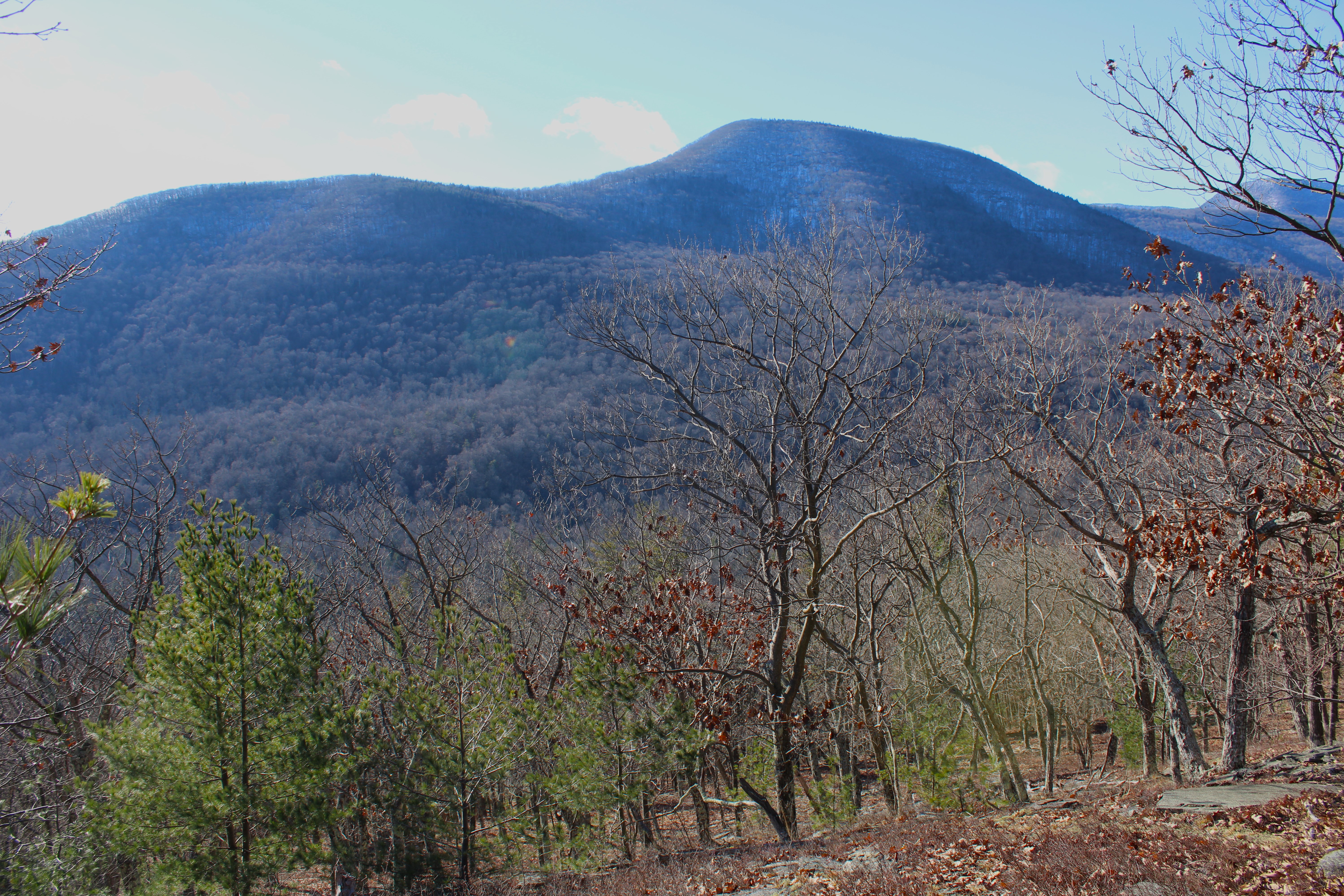
From the same spot, Hunter Mountain's steep east facing slopes tower directly across Stony Clove Notch.  There are some good views from some off trail ledges over there as well.


As I fought my way up through the steep terrain, the view south grew a little broader by the minute.


I continued a very challenging ascent up through a series of dizzying ledges and cliff bands, which were a bit scary in spots.


A small shelf provide a nearly vertical view down into the Notch.  Scenes like this were quite common on my way up the mountain and I had to struggle to find a chute up in spots.


At about 3100 feet, I turned back south towards the trail, hugging a steep area of ledges.  One spot in particular provided the best vista of all....perhaps one of the best I've seen in the Catskills at all.  A small rock ledge perched high above the valley made it feel like I was on top of the world.  A shoulder of Hunter Mountain sits to the right of Route 214 with Silver Hollow Peak just beyond.

I sat and marveled at this vista for almost a half hour, finding it hard to drag myself away.

From the open ledge, I made my way steeply back down to the marked trail and from there it was an easy trail hike back to the car.   Hiked a tough 3 miles RT with over 1200 feet of elevation gain.  One of the scariest but rewarding bushwhacks I've undertaken in the Catskills.  

Map Below.  Red P=Parking   Red X=Vista   Blue X=Furthest point north on my bushwhack


Pine Mountain(Pine Mountain Unit(DEP)-Catskills)

Headed south to explore 1924 foot Pine Mountain, an obscure peak nuzzled between Route 30 and 23 just east of the hamlet of Grand Gorge.  The mountain sits on NYC watershed land and is really just a small peak with a long, flat plateau on top.  My access point today was from scenic dead end Van Aken Road, where public land is nestled among the rolling pastureland of an active farm. 

I parked on the shoulder of the road(Elevation 1380 feet), just past the public land boundary, where an opening in a barbed wire fence provides the point of entry.  Within just a few moments of climbing through the open pastures, a great view west beyond the working farm opens up.  Grand Gorge sits snug in the valley between Irish Mountain(left) and SE Morseville Range(right), with much smaller Jump Hill down below.  In the distance to the far right is some of part of the rest of the Moresville Range.

Beyond the open pastures, I hit the open woods, where the mountain's namesake pine trees began to take over. 
A steady but uneventful ascent brought me up to an enormous meadow at just over 1800 feet.  The meadow is quite open and flat and seems like a perfect place to spot a deer, which is exactly what I did when I arrived here.
A few yards past the open meadow sits a large vernal pond, which had a light coating of ice on this frosty morning.
I circled around to the western shoulder of Pine Mountain, where I found some impressive, enormous old wolf trees in a clearing.
Continuing east through the open woods, I made my way past a maze of stone walls and woods roads to arrive at the plateau like, pine covered 1924 foot summit.
On the descent, which I kind of zig-zagged my way around, I stumbled upon the remnants of a small, old, long abandoned quarry.
A light coating of snow on the tree branches overlook this stone wall on the steep southern slopes of the mountain.  Stone walls literally dotted nearly every corner of the mountain I hit.
Eventually made my way back down to the open pastures and accompanying great vista into the western Catskills.  By this time of the day, the sun had melted away all of the morning frost and warmed the temps into the mid 30s.

A nice and easy day of meandering around in the woods for a total of 2.8 miles and over 600 feet of ascent.  Map below.  Red P=Parking  Blue X=Summit


Thursday, December 14, 2023

Mount Pleasant SE Knob(Traver Hollow Unit-DEP/ Slide Mountain Wilderness-Catskills)

Headed down to the Catskills to do a little off trail exploring to an unnamed 2125 foot high point on Mount Pleasant's far SE ridge, utilizing both NYC Watershed land and State land.  Parked in a small DEP pull off on Traver Hollow Road(room for one car), elevation 950 feet, and headed northeast into the open woods. The slopes were steep and littered with fallen leaves, which made for a somewhat slippery ascent. Thankfully, as I neared the top of the ridge over 1300 feet, many of the leaves were replaced by flat rocks that made for easier climbing.

Once I emerged atop the ridge, the woods really opened up and provided some very good screened views east towards the Ashokan Reservoir.

From an open ledge above the steep NE slopes of the ridge, I found great views over Boiceville and Route 28, with Piney Point and Ticetenyck just beyond.

From the same ledge, looking north towards Mount Tobias.

Heading up over the top of the ridge again, I stumbled upon-literally-the best seat in the house.  A stone seat propped up with a killer view towards Samuels Point.

A few yards away from the stone seat, I enjoyed this view of Samuels Point with the top of Wittenburg poking out high above Traver Hollow.

Directly across Tracer Hollow rises Little Samuels Point(left) and Samuels Point(right).

Continuing on my way NW up the ridge, I soon encountered mountain laurel, which became increasingly thick on the ridge line.  Staying just off the ridge to the north, the woods remained nice and clear though.

My intention was to ease my way down the north slopes of the ridge, through a deep cirque, and then onto an old quarry at about 1150 feet.  The woods remained very open and easy to navigate with no snow or ice to contend with.  In no time at all I found the old quarry I had been searching for, as well as a few other abandoned ones too.  From the top of the quarry, the views east over the Ashokan Reservoir were quite nice.  A unique vantage point for sure.

From the top of the quarry looking NE over Boiceville and Route 28.

Carefully made my way down to the inside of the quarry and some impressive tailings piles.

Just above the old quarry is an overgrown former quarry road that climbs up through open hardwoods and sedge grass.  I passed by at least one or two more smaller quarries just above this.

Followed quarry/ woods roads up to around 1600 feet, before the one I was on petered out to nothing, forcing me to bushwhack straight up the steep north slopes of the ridge.  At around 1700 feet I began to encounter the first few patches of snow here and there.

A straightforward, steep climb up through open hardwoods brought me up to the 2125 foot summit, which is laced with mountain laurel.  I found one small clearing at the top, which was covered in about an inch of snow. 

From the summit, I descended SE through several thick patches of mountain laurel, while hugging the state boundary line.  There were many through the trees views but nothing too great to speak of.

While under nearly 100% sunshine high up on the ridge, once I dropped back down into Traver Hollow, darkness and late afternoon shadows quickly swallowed me up.  Sunsets come early this time of year-especially in the deep hollows.

Covered about 3.5 miles RT, with over 1600 feet of combined ascent.  

Map Below.  Blue P=Parkng  Black X's=Views atop SE ridge  Blue=Quarry Views  Red=Summit Knob


Thursday, November 30, 2023

Lawson Lake County Park(Town of New Scotland, Albany County)

Finally had a little free time Thursday afternoon to do a little exploring at Albany County's Lawson Lake Park, located off CR 109 in the town of New Scotland.  It has been several years since my last visit here, so it was nice to rediscover these woods once again.  Parked in the lot on Lower Camp Road just south of Lawson Lake(Elevation 750 feet) and then walked the service road to its end to check out the lake itself.  This is the view north near the dock along the west shore.

Backtracked south to the Loop Trail, and then broke off onto a yellow blazed trail, which hugs the southwest perimeter of the park.  Even though I started my walk at about 2pm, daylight was already showing signs of fleeting in the late autumn woods.


After completing the western trails in the park, I crossed over CR 109 to the east side and picked up the Upper Camp Road.  This service road climbs quite steeply up to a campsite with several cabins, before a foot path heads up to a red marked "Summit" loop trail.  This trail hugs the outside of the small, flat summit of a 1003 foot hill, with decent views through the bare trees. 

From the red summit trail, I bushwhacked east, dropping down and crossing over a "Notch" trail on my way to a slightly higher hill.

There is no trail on this 1038 foot eastern hill, but the woods are quite open and easy to explore.  Unfortunately, public land doesn't extend all the way to the true summit, although it does hit the summit plateau.

Followed the edge of the steep western slopes of this hill, where I found numerous game paths but not much in the way of views. 

Explored the hill all the way to the south edge of public land before bushwhacking my way back down to Upper Camp Road and eventually my car.  A nice and easy 2.8 miles RT, with 500 feet of climbing.  

Map below.  Red P=Parking


Thursday, November 16, 2023

Tawasentha Park(Town of Guilderland, Albany County)

We've all heard of common phrases such as "No Shave November", but this year for me has been "No hike November". Finally had a brief window of opportunity so did a short hike at Tawasentha Park off of Route 146 in Guilderland on a gorgeous mid November afternoon.

There are several different colored trails that meander through the woods of the park, with the highlight being the ones along both sides of the Normans Kill.
Covered a little over 2 miles on a beautiful, short sleeve fall day.  Shockingly only saw one other person in my travels.

Tuesday, October 31, 2023

Lookout Point(Mohawk Trail-Connecticut)

My second stop for the day in the Litchfield Hills of NW Connecticut was a short trail hike to Lookout Point on the Mohawk Trail, a large set of rock ledges easily visible from Route 7 in Canaan.  I got started by parking along the Warren Turnpike(Elevation 575 feet) just north of the Housatonic Valley Regional High School and headed east on the trail. The start was a bit tricky, as I had to cross train tracks and then travel through a wooded area near people's backyards, before emerging at a road crossing of busy Route 7.

Once on the east side of Route 7, the trail climbs quickly and becomes quite rugged.  The ascent is short but relentlessly steep and rocky.

Once on the ridge, the trail mellows out nicely and becomes a gorgeous woods walk.  A carpet of freshly fallen leaves made for perfect hiking.

After a very brief down and then up, I emerged at Lookout Point.  The views south down the Housatonic Valley are very nice.

To the west, the large, bulking mass of Sharon Mountain looms large above Route 7 winding below at its foot.

A fine place to kick back and soak in the views.

From Lookout Point, I retraced my steps back towards the car, including a very steep descent.

A pretty crossing over the outlet of nearby Childs Pond on a sturdy footbridge.

A nice and easy 2 miles round trip with over 600 feet of ascent.  Short, steep but sweet.  

Map below.  Red P=Parking  Blue Line=Route taken