Search This Blog

Saturday, June 26, 2021

Lisha Kill Preserve(Niskayuna, Schenectady County)

Did a short after dinner walk at the Nature Conservancy's Lisha Kill Preserve on a breezy, humid summer evening.  The muggy weather must've kept people away because there was only one other person out walking their dog while I was there.

The trails quickly drop down into a ravine, where the Fly Kill, a small tributary stream runs through.
The trails are very pleasant and well marked, passing through old growth forests, where some trees are over 200 years old.  I followed the red trail over to the yellow blazed "Frank's Trail", before returning to the red marked "Grattan Family Trail", which eventually drops down to the Lisha Kill.
The Lisha Kill was a lovely sight on this humid summer evening.  I did see someone with their dog splashing around in the water, enjoying the cool creek just upstream from this photo.
Took all three trails at the preserve for a total of about 2.1 miles, and worked up a decent sweat in the process.  Woods were a little buggy, but not too bad.
 

Thursday, June 24, 2021

Dyken Pond Environmental Education Center(Grafton/ Berlin, Rensselaer County, NY)

Decided to get out and enjoy a beautiful-dare I say-perfect summer afternoon after work at the Dyken Pond Environmental Education Center up on the Rensselaer Plateau.  I was a bit tired from work, but had to take advantage of the nice weather so decided to do a little easy hiking on the quiet, wooded trails here.  Much to my delight, there was only one other car in the lot(Elevation 1650 feet) when arrived, so I first headed east a short distance down to the Shoreline Trail along Dyken Pond's west edge.

I followed the shoreline north, enjoying a few decent views across the open water.  There was a couple out in a kayak, presumably the other car in the parking lot.

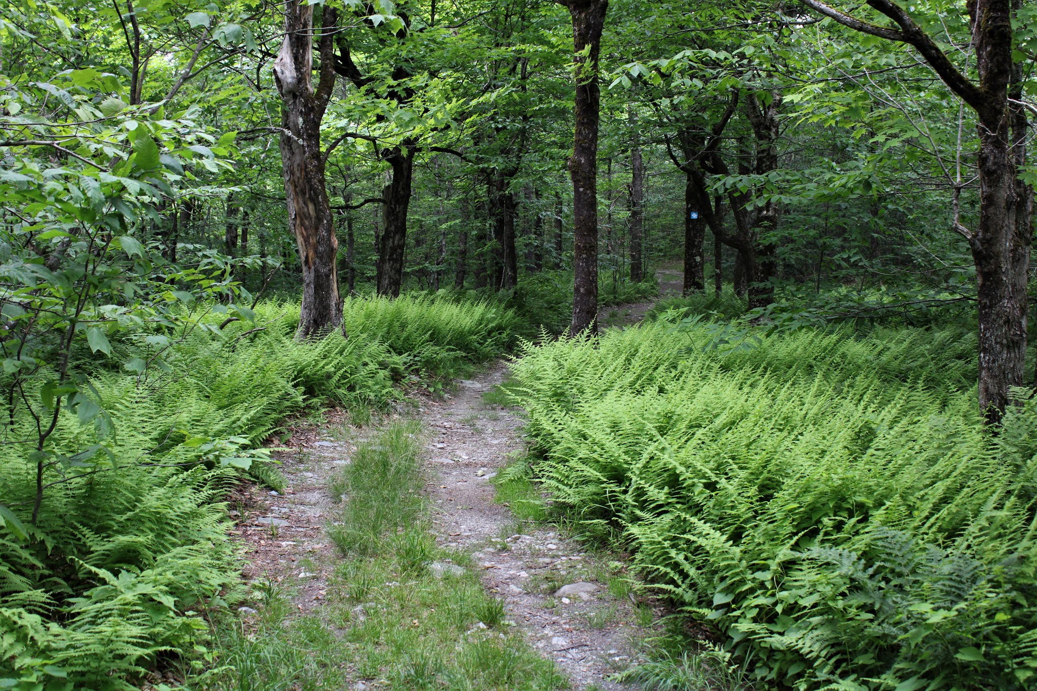
After leaving the water's edge, I took various trails through the expansive woodlands north of Dyken Pond Road, passing through countless fern glades.

One of the newer additions to this land is the area around Newcomb Pond, which was added about five years ago and offers some nice views of this large wetland from an orange blazed trail.

After checking out most of the trails north of the road, I did a little exploring south of the road as well near Dustin Swamp.

One of the most well known features of the Dyken Pond Education Center is the long, winding footbridge across Dustin Swamp.  It's perfect in its imperfection.

Hiked nearly 4 miles total for the day on many of the trails at the Center, enjoying the low humidity and pleasant breeze.  Was a little surprised to not see anybody else out on the trails on such a gorgeous day.  The heat and humidity will be with us in no time, so was glad to get out and enjoy the weather while it's here.


Monday, June 21, 2021

Canaan Mountain Ledges(Litchfield County, Connecticut)

Headed east into the hills of Litchfield County in NW Connecticut to check out a series of open ledges along the steep west slopes of Canaan Mountain this afternoon.  Unfortunately, almost on cue, extreme heat and humidity greeted me on this first full day of summer, so-although steep-this would be a fairly short hike.  I parked in an unmarked parking area on the east side of Route 7 in the town of Canaan(Elevation 725 feet) and headed east through thick weeds until I hit the wood line and Connecticut State Land discs.

Once in the woods, I picked up an unmarked but obvious herd path.  Followed this herd path quite steeply up to a green blazed trail, which continues a very, very steep ascent.

Once on the ridge, after nearly 800 feet of climbing in about half a mile, the green trail(mixed with white blazes as well) finally levels out a bit and turns north.  Followed this trail until a yellow blazed trail comes in from the west, which I picked up and continued north along the ridge.
The yellow blazes hug the very steep western slopes of the mountain, soon emerging in a series of small ledges and clearings. 
With the leaves on the trees, the first couple of ledges offered just teasing views, until a nice, open ledge finally provides a wide open vista.  Dripping in sweat, I stopped to enjoy this nice view to the SW into the sweltering, soupy air mass.
Just a very short distance north of the first set of ledges is a second, much broader area of open rock, at just over 1500 feet in elevation, where the views are outstanding.  These nearly 180 degree views stretch from the south/ SW all the way to the north with Route 7 far, far below.
My favorite view of the day is to the NW from these wide open rock ledges.  This view takes in the peaks of the Appalachian Trail(left to right on the horizon) Bear, Race and Everett.
After enjoying the spectacular views, I began heading back on the yellow trail. Instead of returning the way I had come, however, I decided to follow the yellow blazes on an even steeper descent than my route up. 
This route ended up being quite fun and even a bit challenging, with two ladders and a huge boulder squeeze to get through!  Rope was found in a couple of steeper spots as well.
Once off the steepest part of the descent, I picked up a red blazed trail which heads south at the foot of the serious cliffs I had just come down.  If you look carefully, you may be able to pick out one of the ladders near the center of the photo.
Followed the red trail all the way back down to the unmarked herd path which all but disappears at the bottom, in thick brush.  Pushing through the tick infested weeds, I stumbled upon some kind of old foundation which happened to be only a few yards away from the parking area.

Got back to the car, literally drenched in sweat.  The only saving grace today, was a gusty south wind that at least helped me from getting too hot.  About 3.5 miles total and nearly 1000 feet of ascent and had the woods to myself.
 

Friday, June 18, 2021

Snow Hole(Taconic Crest Trail-NY/ Vermont)

Did an easy hike along the Taconic Crest Trail after work this afternoon from Petersburg Pass north to the Snow Hole.  Morning sunshine was quickly yielding to cloudy skies when I arrived at the large parking area along Route 2 at Petersburg Pass, just west of the Massachusetts state line(Elevation 2080 feet).  I safely crossed Route 2 and headed north into the woods, following the blue and white blazes of the trail.  

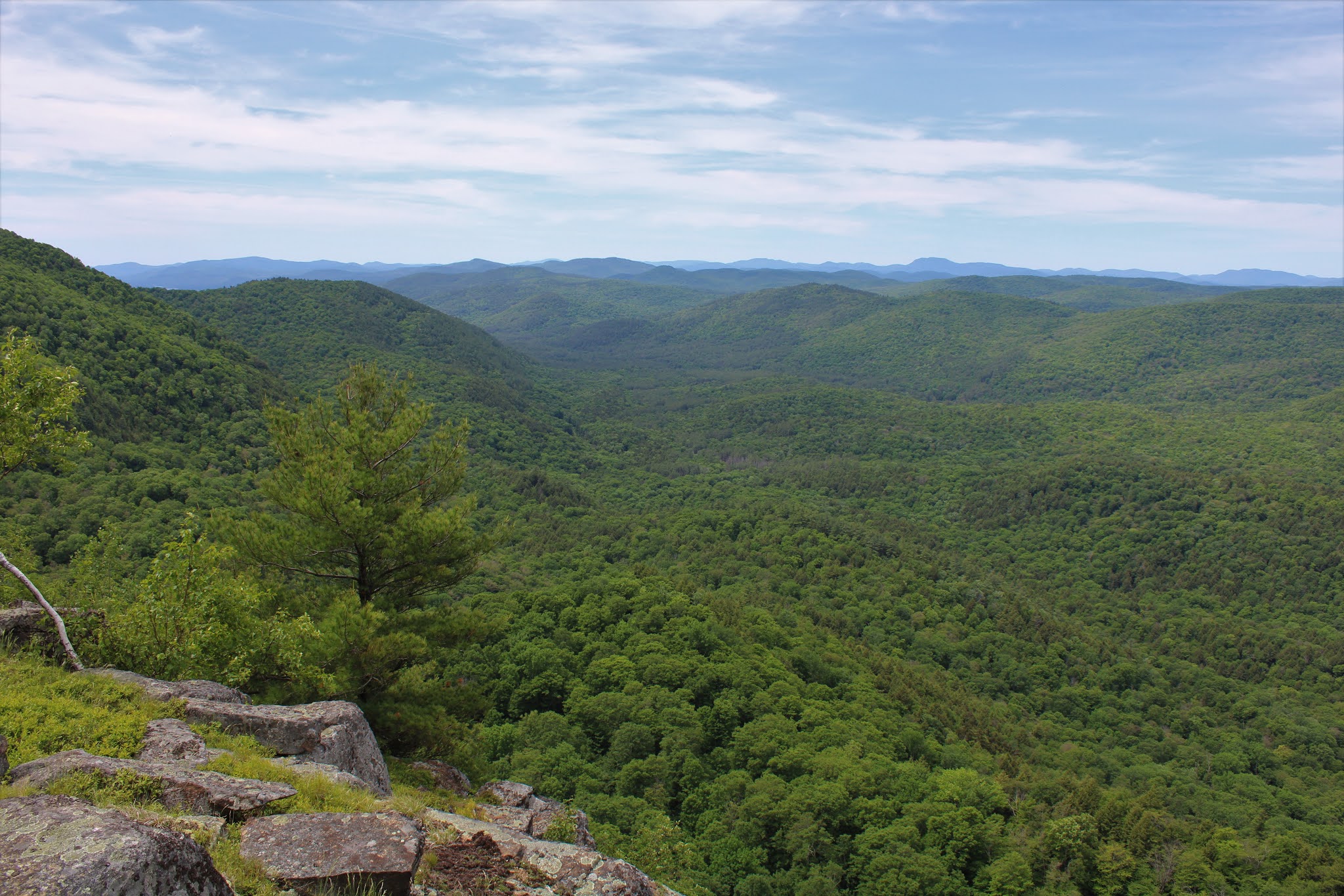
Immediately upon entering the woods, the trail climbs steeply up to a Hopkins Forest kiosk and trail register, just before an informal herd path leaves to the left.  This side path is short, but very much worth the minimal effort, as the best view of the day can be enjoyed here.  To the west/ northwest the view stretches across the Route 22 valley near Petersburg and reaches into the hills of the Rensselaer Plateau.

From the same viewpoint but turning slightly more due west, with the Taconic ridgeline above East Hollow in the foreground.
The Taconic Crest Trail is wide and easy to follow as it basically straddles the crest of the Taconic ridge, passing through a dizzying array of fern glades along the way.  If you love fern glades, then this trail is definitely for you.
Continuing north, the trail passes just beneath the summits of White Rocks and Smith Hill as it makes its way towards the Vermont border through a handsome hardwood forest.
After just over 2.5 miles of fairly easy hiking, the trail comes to a view point near the top of White Rocks Mountain.  Unfortunately, the clouds were really thickening up by this point, muting what is a decent view to the south and west.  This view to the south takes in Mount Raimer as well as Route 2 at Petersburg Pass where the hike had started.
With dark clouds rolling in and a pleasant breeze picking up, I continued north, thoroughly enjoying the peace and quiet of these high elevation woods.
A short, red blazed spur trail breaks away from the Taconic Crest Trail around the 3 mile mark heading right(east) and slightly down to the Snow Hole.  While the temperature was in the upper 70's on this mid June day, the air inside the Snow Hole(which is a very large, deep crevasse)was noticeably colder.  After a deep climb down to the bottom, I found what I was looking for.....snow.
While this spot is really an interesting area to see and explore in person, it is difficult to seize the magic of this location on camera.  Climbing back out of the Snow Hole, I was able to get this shot, which I thought kind of captured the rugged beauty a little.
I used the Snow Hole spur trail as my turn around spot and began heading back south on the TCT, zipping right along.  Made one small pit stop off trail to the Vermont SW Corner Obelisk, which sits right at the state line. 
One side I'm in Vermont, the other I'm in NY.  There was some very old state identification engraving into the marble, dating back to the 19th century.
An easy bushwhack brought me over to the trail, which I followed all the way back to the car.  Trail conditions were very dry, which is a bit surprising because it is usually very damp and muddy along the Taconic Crest Trail.
Arrived back to the car and began to feel some light sprinkles falling as I got in.  Hiked about 6.3 miles total and only saw one other hiker all day.  Elevation gain was around 800 feet total, including my side venture off trail.
 

Wednesday, June 16, 2021

Normans Kill Ravines Park(Delmar-Town of Bethlehem, Albany County)

Decided to pay a visit to the brand new 147 acre Normans Kill Ravines Park, which is found less than one mile north of the Four Corners in Delmar off of Wright Lane(North Road Extension).  A kiosk and parking area with room for about ten cars marks the start of the trail system, which is blazed in white. 

With temps hovering around 70 accompanied by a light breeze, no humidity and mostly sunny skies, conditions were perfect to do a little exploring.

Within just a few moments on the trail, an odd sense of remoteness seemed to click in.  I really enjoyed the vibe that this natural oasis provided from the hustle and bustle of nearby suburbia.
There are currently two marked trail options(Full Loop and Shortcut)at the park, but in reality there is actually a profusion of unmarked paths that can be found all over these woods.
I was truly floored by the amount of wildlife and sense of nature I found in these woods, yet being so close to a large population.  I counted at least four deer that I spooked or got within just a few yards of, as well as countless squirrels, chipmunks and birds.
The highlight of the park is the northern section along the Normans Kill, where the trail closely hugs the water for nearly a half mile.  While there is a true sense of solitude here, nearby on the opposite shore you may hear the sounds from the Capital Hills Golf Course.
For some reason, the Normans Kill has a brownish-dirty mud puddle appearance which obviously doesn't make for great photos.  At a slight bend in the creek, where the trail departs the waters edge, I was able to get one halfway decent shot.

A pleasant view west, upstream on the Normans Kill.  The shoreline is quite muddy and sloped, so getting close to the water can be a bit challenging.


Leaving the Normans Kill, the trail then begins to follow a small, muddy tributary, which weaves its way through the woods.

There are numerous footbridges scattered throughout the woods, which cross over small tributary streams as well as small ravines.

It will be fairly obvious to anyone who hikes here just how they arrived at the park's name.  I meandered my way through the woods, weaving in and out and up an down countless small ravines until I finally made my way back to the car.  An interesting 3.5 miles total and had the woods to myself on a very pleasant late spring afternoon.
 

Thursday, June 10, 2021

Prosser Hollow(Taconics/ Petersburg, Rensselaer County)

Decided to re-visit the Prosser Hollow Trail in rural Rensselaer County this afternoon, a trail that is not very popular and also one I hadn't climbed in a few years.  I parked at the corner of Prosser Hollow Road and Lewis Hollow Road, being sure to get my car out of the road completely(Elevation 985 feet).  If you so choose, there is a very rough access road that leads uphill to a large parking area in a clearing, but only if you have high clearance and take it slow.  From the corner of the parking area the trail basically heads east and climbs straight up to the Taconic Ridge via an old woods road, which is wide and easy to follow, although steep.

The very first section of the trail down low is a bit wet and muddy, but from there it becomes exceedingly dry with good footing the rest of the way.
At the head of the hollow, and after just under 900 feet of climbing, the yellow blazes of the Prosser Hollow Trail are finally replaced by the blue and white blazing of the Taconic Crest Trail. 
Once I hit the Taconic Crest Trail, I turned left(north) and headed up to the top of the next ridge, which was less than a quarter mile away.  The 2008 foot "summit" sits in a bit of a clearing and makes a nice spot to stop and relax.

The ravages of time and summertime growth have taken away any kind of view to the west, where there once was a good view.
Fortunately to the east, there is an open viewpoint in the clearing towards Vermont.
Very nice view east into the rural Pownal, Vermont countryside.
After grabbing a quick drink, I headed back down to the car, really zipping along on the steep descent.  As expected, didn't see another soul and hiked just under 3 miles RT with over 1000 feet of climbing.


Middle Mountain(Lake George Wild Forest-Adirondacks)

Headed north today on a refreshingly beautiful late spring day to do a little exploring in the Lake George Wild Forest around Jabe Pond and 1867 foot Middle Mountain to its west.  I chose to park at the beginning of the dirt access road to the pond(Elevation 1070 feet) and walk it, although it looks like it has been recently graded and smoothed out.  There are a couple of small steep spots so low clearance cars still may want to walk the one mile in.  In any case, it is a very quiet and pleasant road walk mid week.

Just about one mile south, the road comes to a large parking lot and information board about the pond.  From here, a trail drops down to the pond and then follows its north shore providing access to several small campsites.  Here is a view across the open water of Jabe Pond with Middle Mountain to the SW in the distance.

The trail around the pond was nice and easy to follow until it came to a cove and adjoining wetland on the west side of the pond.  I lost the trail here and had to circumvent my way around it, circling around to the spot I wanted to begin my bushwhack.  


Once I began my bushwhack, it was a pretty straighforward route west between a couple of small peaks, then towards Middle Mountain's east slopes.  At the foot of the peak I came across this pretty beaver pond.


Pink lady slipper well off trail.


The climb up Middle was fairly pleasant through mostly open woods and even a large area of fern glades near the top.

The area around the summit is surrounded by small cliff bands and sedge grass making for fun bushwhacking.  Although it is open, the true 1867 foot summit unfortunately offers up no views. 
Just a short distance south off the summit are a series of small viewpoints to the west from extremely steep and nearly vertical ledges.  Although each view is nice, there is one open ledge on the SW slopes in particular that offers up tremendous views.  This is a look NW with Beech Mountain in the center from the open viewpoint.
From the open area, the view southwest over the Fly Brook valley is quite dramatic.

Circling around the ledges, I found an impressive view of Catamount Mountain to the south. 

Stellar views south towards Catamount, which almost looked close enough to touch!
I could've stayed here all day soaking in these views, but unfortunately the deerflies had other ideas.

After enjoying the amazing views, I headed back down the east side of the mountain and back over to Jabe Pond.  Instead of heading straight back to the car, I made one last pit stop to Little Jabe Pond, which sits just north of Jabe Pond.

From Little Jabe, I bushwhacked straight over to the dirt access road, which I then followed back to the car.  A very nice 6.8 miles RT with 1300 feet of combined ascent, and only saw one other couple out walking their dog early in the morning.

Blue X=Parking   Red X=Summit  Black X=Appx area of ledges