Search This Blog

Friday, April 29, 2022

Unnamed "North Fork Boquet" Peaks(High Peaks Wilderness-Adirondacks)

If one were to measure open rock in the Adirondacks, I'm confident that the area formerly known as the Dix Wilderness would win hands down for having the most.  There are many different peaks that I have hiked to in this area, and nearly all of them have a decent amount of open rock slab to explore.  Such was the occasion today, when I chose to visit some unnamed peaks near the North Fork of the Boquet River on a delightfully cool late April day.  I parked in an unmarked pull off(Elevation 1335 feet) on Route 73 just past the bridge crossing over the North Fork and was a bit surprised to have the place to myself.  Crossed the road and picked up the North Fork Trail along the north side of the river, dropping down briefly to check out the rushing water.  Too cold for a dip today!

I followed the high water herd path, which for all intents and purposes is a trail, just unblazed, until a tributary crossing at roughly 6/10 of a mile in.  Once across the stream, I left the herd path and began a steep bushwhack through very open woods.  As I neared the top of the eastern most summit, I began to encounter some open rock, with views towards the Dix Range through the trees. 
Just south of the 2105 foot eastern summit, a very broad, expansive area of open rock slab and ledges offers up splendid views of the Dix Range, with the North Fork flowing down below. 

The views from these ledges are nothing short of spectacular.  This view is to the southeast, with Lilypad Pond visible down below.
There are no shortages of views towards the Dix Range, from multiple different vantage points along the south edge of this peak.
To the west stands an unnamed peak, labeled 864m on topo maps, as well as my next peak along the ridge to the right.  Noonmark is visible just beyond those peaks in the distance.

After enjoying the wonderful views atop the eastern summit, I continued on to the NW, slowly dropping towards the saddle between the peaks.  From a small, rocky clearing, I was able to garner this nice view at the western summit.

After carefully dropping down a steep set of cliff bands, I made my way up the next peak through more remarkably open woods.  Hard to beat bushwhacking like this!!
There was even more open rock on the western summit, which was also nearly 300 feet higher as well.

Spectacular views south towards the Dix Range once again, this time from the western summit.  A small rock ledge from the eastern peak is visible in the lower left corner as well.

Peak 864m to the left and Noonmark to the right.
After hitting the wooded 2380 foot summit, I began to explore some of the north slopes of the western summit, finding even more open rock.  Here is a wide open view to the east, with the eastern summit in the center.

One of the best views I found all day was this amazing perspective of Giant and Rocky Peak Ridge to the northeast.  Round Pond and Twin Pond sit far below at the foot of the mountains.

Exploring the northern slopes provided me with several incredible views towards Giant and Rocky Peak Ridge.  Not too shabby!
After finally pulling myself away from the great views, I carefully descended down the steep north slopes of the peak, eventually finding myself in a vast clearing with Twin Pond's outlet flowing along.
The large clearing is thanks to the beavers in the area, who have dammed the brook and created a large, sprawling beaver pond and meadow. 

From the beaver pond, I basically followed the outlet back to the herd path, and from there it was an easy hike out to the car.  Had the woods to myself on this breezy, but bright and sunny spring afternoon.  5 miles RT, with just under 1500 feet of ascent.

Map Below.  Blue P=Parking  Red X's="North Fork Boquet" Summits


Tuesday, April 26, 2022

Island Pond, Long Pond and unnamed Long Pond Hill(Lake George Wild Forest-Adirondacks)

Headed up into a quiet area of the Lake George Wild Forest on an overcast morning to do a little exploring to a pair of ponds and a small peak that looked like it may have some views to offer.  I would be getting started from Padanarum Road Spur, which is a very rough(in spots) single lane road that heads deep into the wilds of the Adks.  There were many small branches and ruts in the road that made it a very slow go in my low clearance sedan, so I decided to park(Elevation 1160 feet) about 3/4 of a mile east of the beginning of the snowmobile trail to Long Pond.  Anyone with a high clearance vehicle could easily make it all the way in, but for me it just added in some road hiking. 

After the quiet road walk, I turned right, north, and headed onto the marked snowmobile route towards Long Pond.  Much to my surprise, there was an SUV parked in the unmarked parking area here.
As I started on the trail, the sounds of rushing water could be heard, so I headed a few yards off trail to check out a small area of cascades on an unnamed brook.
Back on the trail, it was an easy hike up to an enormous beaver pond, which is actually quite scenic, but unfortunately also spreading out over the trail.  Several areas along this stretch of trail have been completely washed out and need to be carefully avoided.

Once I made my way around all of the rerouted areas, it was smooth sailing up to a high spot on the trail, where I began my bushwhack up the small, unnamed hill southwest of Long Pond.  The woods were wide open and easy to hike through, as I made my way up to the 1585 foot summit.

From the top of the peak, there are good views from some several open areas.  This is a view NW towards Brant Lake.
From a patch of open rock, a nice view east unfolds.
From the northeast side of the summit area, a nice view takes in Long Pond.

Open summit ledges with Long Pond below.

After enjoying the views, I bushwhacked NE down to the marked snowmobile trail, which brought me over to Island Pond.  The trail dead ends at a wet spot directly on the pond, but an easy bushwhack east/northeast skirts the edge of the pond and offers up some nicer water views. 
Circling around to a spot on the east side of the pond, I found a very nice informal campsite with a view towards the pond's namesake island.

I really liked that area on the east side of Island Pond.  Highly recommended via a short bushwhack. 

Back on the trail, I headed over to neighboring Long Pond which also looks to be a beautiful body of water.  From a spot on the south shore, I enjoyed another informal campsite with good water views.  Not sure how good the fishing is, but looks like a nice spot to try. 

From Long Pond, I headed back south on the trail, but instead of trying to get around the the beaver ponds and flooded trail, I bushwhacked far off trail up a small, unnamed peak due south of Long Pond.  The woods were quite open and easy to navigate up to the 1500 foot summit.

From the top of the small peak, I dropped south and east back down to Padanarum Road Spur and onto my waiting car.  Didn't see anyone else all day(including the driver of the SUV at the trailhead), and somehow also avoided the incoming rain.  A nice and easy 5 miles RT, with 700 feet of ascent.

Map below.  Red X=Parking     Black X=Open area atop "Long Pond Hill"      Blue X's-Informal camp sites I visited


Wednesday, April 20, 2022

Thacher Park via Ryan Road(Thacher State Park, Albany County)

Following yesterday's spring snow storm, I thought I'd head up to Thacher Park in the Helderbergs to do a little exploring and see how much snow was left behind.  When I hike Thacher Park, I usually prefer to hike the trails off of Ryan Road or Carrick Road because the woods are generally much quieter and peaceful.  That was certainly the case today as I was the only car in the lot as I set out, trudging through several inches of quickly melting snow.(Elevation 1355 feet at the Trailhead)


Took a moment to check out the picturesque pond along the Perimeter Trail, which actually looks like it belongs in the Adirondack wilds. Although the sun was out and temps were warming into the 40's, a cold wind kept me moving along.

Conditions on the trails were quite sloppy, and deteriorating fast as the strong April sun was melting the snow into slush and mud.

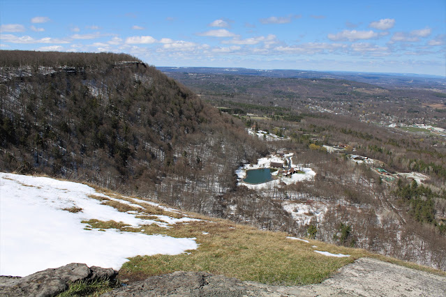
Made my way over to the Hang Glider View at the edge of the escarpment, which never disappoints.  As clearly visible in this photo, the valley is nearly 100% free of snow, while the ground remains all white up high.

Views towards High Point.

Rapidly melting snow along a section of the Long Path.

One of my favorite trees in these woods.

Back on the Perimeter Trail, where spring buds and deep snow make for quite the contradiction.

Hiked about 3.5 miles through gloppy, and at times very muddy, conditions.  Even given the conditions, I was shocked to not see anyone else out in the woods all day.


Friday, April 15, 2022

Unnamed Clear Pond West Ridge & Moxham Mountain's West Ridge(Vanderwhacker Mountain Wild Forest-Adirondacks)

Did a little exploring in the central Adirondacks today, utilizing the Moxham Mountain Trail to visit some ledges well south and west of the actual trail.  I parked at the Trailhead for Moxham Mtn off of 14th Road in Minerva(Elevation 1610 feet) and set out with only one other car in the lot to start.  The trail, blazed in yellow, gains elevation steadily as it generally heads south.  Skies were highly changeable as rain was moving in from the west, but I took my chances under mostly clear skies to start.


There are some decent early views on trail but they were just the warm up for what was coming later.  At a spot where the trail crosses a small brook, I headed off trail just a few yards upstream to find a large old beaver pond and meadow.

After about 1.3 miles of hiking, at a bend in the trail, I dove into the woods heading south to begin my bushwhack.  After about a 3/4 mile of some slight ups and downs through open woods, I dropped down to the north shore of Clear Pond. 


Clear Pond is nearly all private, but parts of the pond's shoreline(mostly on the north end) fall on state land.

From the pond, the open ledges I was aiming for were only about a 1/4 mile away, but the public boundary runs at an odd angle here, so I took sort of a circuitous route west-then southeast to stay on public land.  There was no mistaking once I found the area I was looking for, as the ledges actually proved to be a vast open area with spectacular views.  Skies had luckily cleared once again, providing a great view to the west up the Route 28 valley.
A short distance down from the open area, I found some nice ledges facing SE towards the Hudson River and  North Creek.

South views over the Hudson River, with Gore Mountain rising dramatically above.
Exploring the open area under blue skies and strong winds that nearly blew me away, but still what an amazing spot.  Without the wind it would be a perfect lunch spot.

While this large open area sits at just around 1900 feet, the views make it seem as though you are much higher.  South views towards Gore Mountain, with South Mountain's ridge in front and Route 28 down in the valley.
The hike northwest along the ridge was nirvana.  Many good views and open woods.  The winds were really whipping on these exposed slopes!  A careful eye can pick out the clouds of tailings from Barton Mines!
The skinny ridge and open woods quickly began to peter out after about 3/10 of a mile so I turned northeast and headed back towards Moxham's ridge.  In a low spot below some of the steep rocky cliffs on Moxham's west ridge I came to a large beaver pond.  I was easily able to navigate around this but the mud almost swallowed me whole in a couple spots.

A stiff climb up from the beaver pond brought me up to the bottom of the moss covered cliffs.
One more steep push up brought me to some really great views, including this killer shot of Moxham's summit to the left.

As I explored Moxham's west ridge, enjoying great views towards Gore Mountain, the skies darkened and showers broke out just south of 28.
Further west along the ridge, skies were a bit more clear, and additional killer views unfolded.

Route 28 carving its way past Starbucks and Black Mountain to the far right and Davis Mountain in the center.
With the rain threat being close by, I decided to cut the hike short and head back ,bushwhacking my way north back towards the marked trail.  Down in one of the steep draws again, I came across yet another beaver pond.  Seemed like these woods were dotted with them.
On the next ridge directly above the beaver pond, I picked up the trail once again, following it directly back to the car and narrowly missing the incoming rain.  Was fortunate to have the woods to myself on this day(even for the trailed sections).  6.3 miles RT, with 1900 feet of combined ascent.

Map below with only off trail navigation in blue.


;