Did a little exploring in the central Adirondacks today, utilizing the Moxham Mountain Trail to visit some ledges well south and west of the actual trail. I parked at the Trailhead for Moxham Mtn off of 14th Road in Minerva(Elevation 1610 feet) and set out with only one other car in the lot to start. The trail, blazed in yellow, gains elevation steadily as it generally heads south. Skies were highly changeable as rain was moving in from the west, but I took my chances under mostly clear skies to start.
There are some decent early views on trail but they were just the warm up for what was coming later. At a spot where the trail crosses a small brook, I headed off trail just a few yards upstream to find a large old beaver pond and meadow.
Clear Pond is nearly all private, but parts of the pond's shoreline(mostly on the north end) fall on state land.
A short distance down from the open area, I found some nice ledges facing SE towards the Hudson River and North Creek.
South views over the Hudson River, with Gore Mountain rising dramatically above.
Exploring the open area under blue skies and strong winds that nearly blew me away, but still what an amazing spot. Without the wind it would be a perfect lunch spot.
While this large open area sits at just around 1900 feet, the views make it seem as though you are much higher. South views towards Gore Mountain, with South Mountain's ridge in front and Route 28 down in the valley.
The hike northwest along the ridge was nirvana. Many good views and open woods. The winds were really whipping on these exposed slopes! A careful eye can pick out the clouds of tailings from Barton Mines!
The skinny ridge and open woods quickly began to peter out after about 3/10 of a mile so I turned northeast and headed back towards Moxham's ridge. In a low spot below some of the steep rocky cliffs on Moxham's west ridge I came to a large beaver pond. I was easily able to navigate around this but the mud almost swallowed me whole in a couple spots.
A stiff climb up from the beaver pond brought me up to the bottom of the moss covered cliffs.
One more steep push up brought me to some really great views, including this killer shot of Moxham's summit to the left.
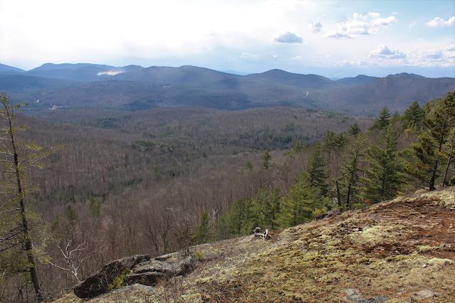
As I explored Moxham's west ridge, enjoying great views towards Gore Mountain, the skies darkened and showers broke out just south of 28.
Further west along the ridge, skies were a bit more clear, and additional killer views unfolded.
Route 28 carving its way past Starbucks and Black Mountain to the far right and Davis Mountain in the center.
With the rain threat being close by, I decided to cut the hike short and head back ,bushwhacking my way north back towards the marked trail. Down in one of the steep draws again, I came across yet another beaver pond. Seemed like these woods were dotted with them.
On the next ridge directly above the beaver pond, I picked up the trail once again, following it directly back to the car and narrowly missing the incoming rain. Was fortunate to have the woods to myself on this day(even for the trailed sections). 6.3 miles RT, with 1900 feet of combined ascent.
Map below with only off trail navigation in blue.
;


.JPG)
.JPG)


No comments:
Post a Comment