Search This Blog

Wednesday, February 28, 2018

Long Path(Berne)

Found a little time after work today to do some exploring along the Long Path in a beautiful area of rural Albany County.  Parked at the corner of Gifford Hollow Road and Switzkill Road in the town of Berne and headed south along Gifford Hollow Road.  Spring was in the air yet again, with temperatures approaching 60 degrees.
The first .2 of a mile is a road walk.  Usually I have a strong disdain for road walks, but today was much different, as the road sees very little traffic, and the views are very nice. Stopped for a moment at a bridge crossing to capture this shot of the Switz Kill rushing along.
The Long Path turns sharply right at a gate, entering a large open meadow.  Aqua blazes mark the way.
The eastern edge of the Partridge Run WMA hovers above just to the south.  This was where I was heading.
If these walls could talk.  Stone walls provide a glimpse into our not so distant past.
Only about 150 yards off the trail and at the edge of the meadow sits a small, but pretty lean to.  Built back in 2011-12, it looks like it sees frequent use, with furniture, wood for burning and reading material all readily available.
The view across the fields from inside the lean to.  The brick fire pit is also one of the nicest I've ever seen on a trail.
Just a few yards behind the lean to is the Switz Kill, which is running quite swiftly.
Back on the Long Path, the trail heads nearly due west through open meadows. 
The views of the surrounding hills are very nice and I found this section very enjoyable.  East Hill can be seen just to the north.
A nearby home sitting pretty, high up on a hillside.
After about .8 of a mile, the trail enters the woods, climbing slowly through the spongy, muddy woods.  A small drainage was an easy rock hop here.
About 1.2 miles into the hike, I crossed onto state land.  This is where the Partridge Run Wildlife Management Area begins.
A steady climb(but not steep at all) brings you up to the escarpment, where the land below begins to drop off significantly.
The Long Path winds its way around the north side of the escarpment heading east, before turning south with pleasant screened views of the valley below.  The hills of Cole Hill State Forest can be seen rising to the northeast.
I continued along the escarpment for a bit, before the trail finally breaks away, heading up to a height of land around 1500 feet.  Fleeting afternoon light made me pick up my pace from here. 
Arriving at Kingfisher Road(a rough 4x4 road), which would be my turn around point. 
Made great time heading back to the car, but unfortunately found nearly a dozen ticks on me.  Just shy of 5 miles total for the day.

Monday, February 26, 2018

Panther Mountain East to West(Catskills)

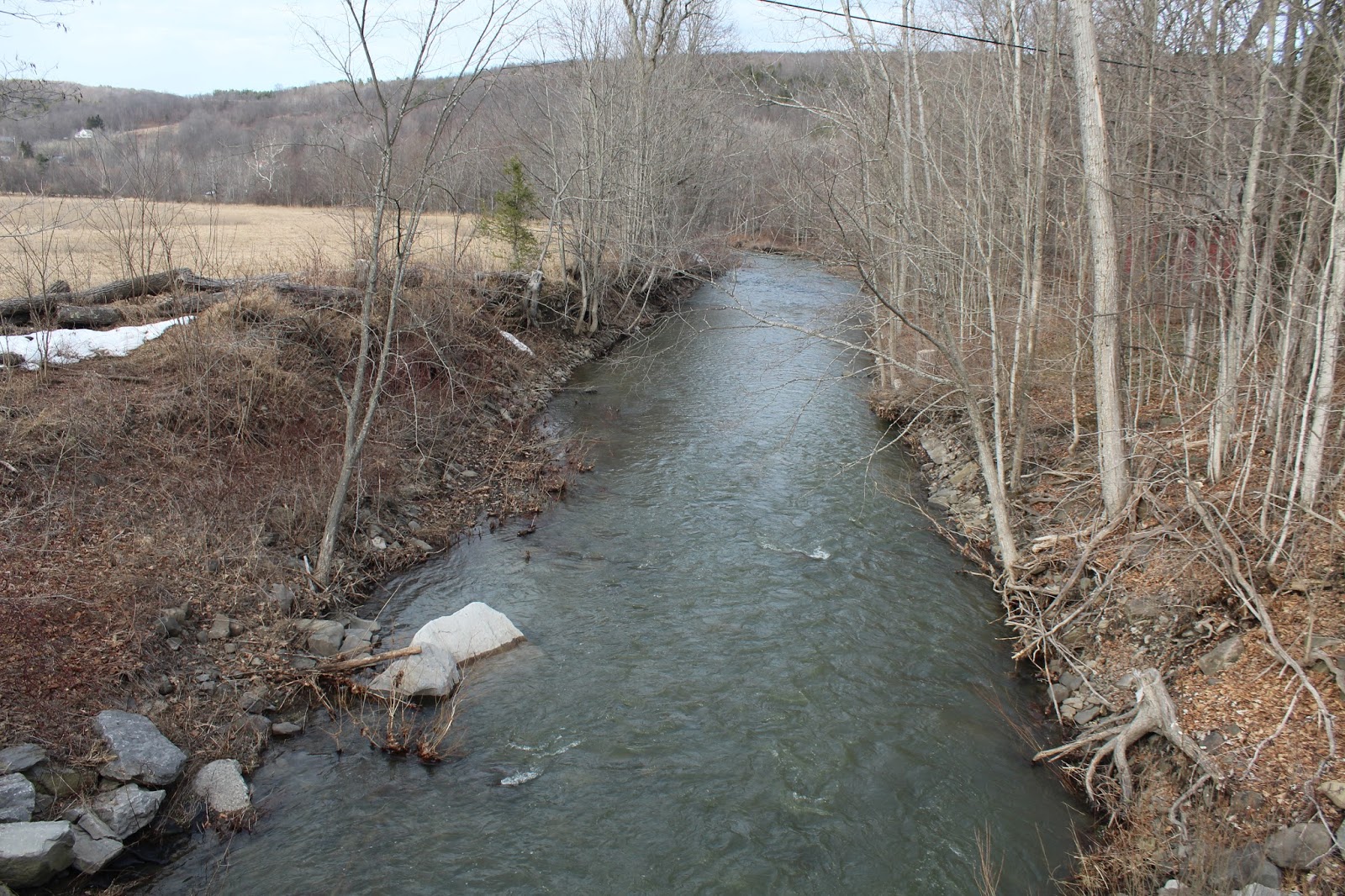
Decided to do a long east-west traverse hike across 3720 foot Panther Mountain with my buddy Jim today.  Jim's friend John would also be joining us for a potion of the hike on what was forecast to be a very spring like 50 degree day.  Spotted a first car in Oliveria along County Route 47 on the west side of Panther, before driving to our starting point along Pantherkill Road, where DEC land meets the road.  Elevation to start the hike was about 1260 feet near the rushing waters of the Panther Kill.
We followed an old woods road up for a while, then swung around to follow a tributary of the Panther Kill up.
The climb up from the valley is quite steep in spots, but there was no snow or ice down low so footing was good.
Jim and John heading up to a series of rock ledges below the ridge line.
Once on the ridge, it was a fairly uneventful hike up to 2700 feet, where we came across the first of two remarkable high elevation clearings.
A rock cairn reminds us that there have been others here before us.
Exploring the clearing, which likely serves a summertime campsite.
On our way toward the second clearing, we passed by this HUGE burl on a tree.
As nice as the first clearing is, the second clearing is quite simply even better.  The up close view of Panther's summit ridge, nearly 900 feet above is certainly a highlight.
The second clearing is much more sizable and provides great views south to Witt, Cornell and Slide.  Slide is easily recognizable in the center of the picture.
Witt and Cornell stand side by side just to the left of Slide.
I wandered across the meadow to capture this great shot of the slide on Slide's north face.
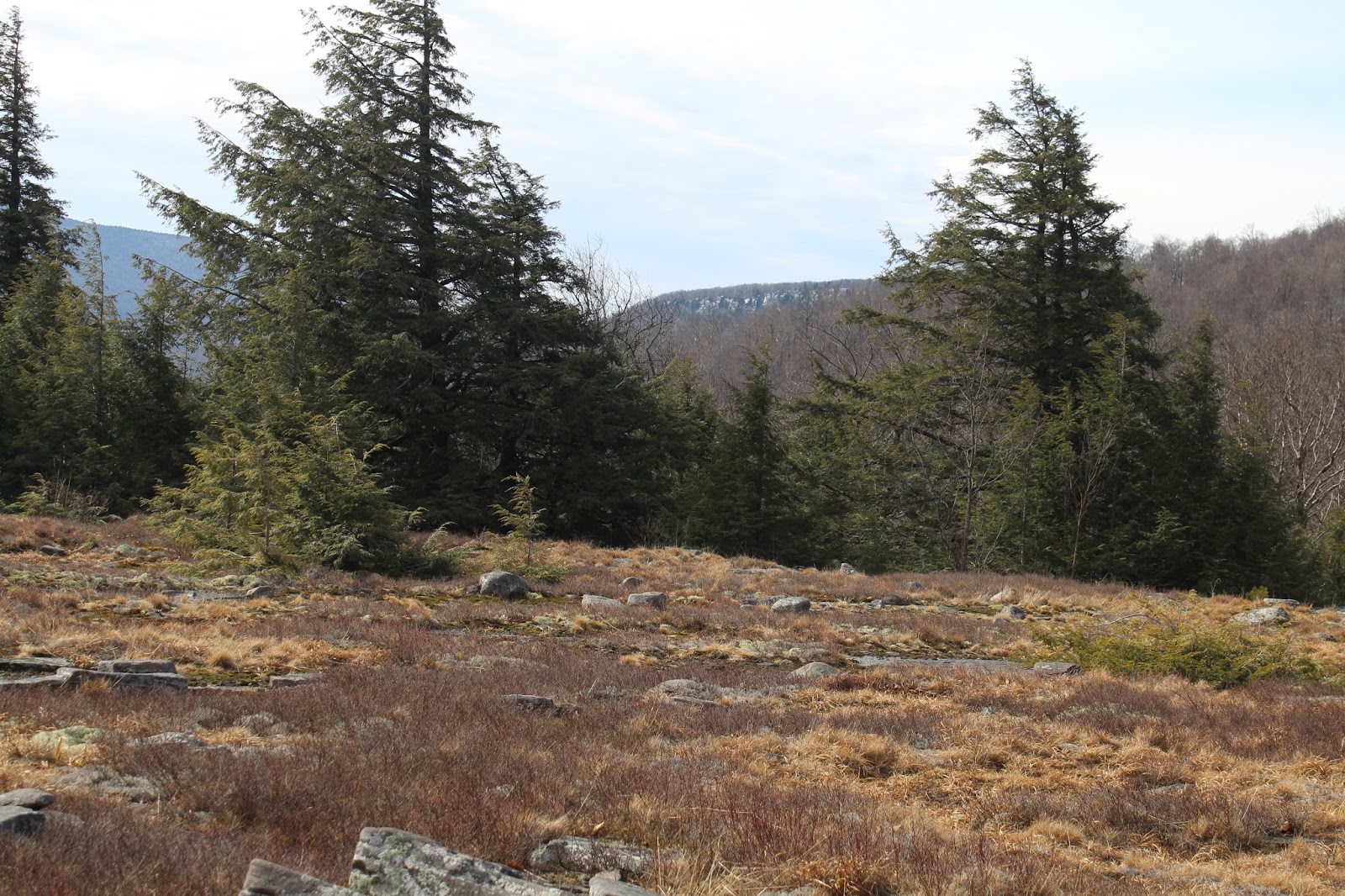
Enjoyed this unique view to Giant Ledge.
Clearing skies provided a fantastic backdrop for our lunch break.
Jim and John(and John's two collies) exploring the wonderful, open clearing with Panther looming above.  John and his dogs turned back here, heading back down to their car.  Jim and I continued on.
As we headed up the steep ridge just east of Panther's summit we finally encountered ice and snow.  A closer inspection revealed ice pellets were melting and dropping from the trees, littering the ground beneath our feet.
At about 3100 feet, we decided to don the microspikes and with good reason.  The conditions turned much more wintry on our way up to the summit.
Just before hitting the summit, we emerged onto the DEC trail over Panther.  We stopped to enjoy the views, which are very nice.  One of Panther's long east ridges, extending down towards Muddy Brook, looks to have some nice rock ledges way up high.
While spring conditions were found down low, true winter like conditions held on to the summit area, encasing many trees in a full coating of ice.
Our GPS showed the second view point as the true summit, my second time here and first in the winter.  I only have a winter ascent of Balsalm Mountain left to meet my requirements to become a 3500 club member.
The spectacular east view from Panther's summit.
From the last view point on the summit ridge, we found a great view back down to the clearing we had just been on. Some refer to this spot as the "Panther Flats" down at 2848 feet.
The view directly down into the Panther Kill valley, with some of the homes further up the road visible below.
We continued north on the trail with a steep and icy descent.
After about .7 of a mile on the trail, we finally and thankfully left the trail to begin our bushwhack west.  Soon after leaving the trail we also took off the spikes. The woods are mostly very open and deciduous but we had a hard time finding views.  This view towards Balsalm and Belleayre through the trees was the best we had. 
The ridge just northwest of the summit is very long and mostly easy bushwhacking.  We did hit some areas of thick prickers which were no problem today.
The ridge was seemingly never ending, as the afternoon shadows grew longer and longer.  Here was a a small vernal pond we found high up on the 2384 foot bump just east of Oliveria Road(CR 47).
The descent off the 2384 foot bump was quite steep, making for slow going.
Just prior to arriving back at the first spotted car, the Esopus Creek and McKenley Hollow Road came into view through the trees.  It was very nice to see the valley floor after a long day in the woods.
Hiked about 10 miles total(9.25 bushwhack) with over 2600 feet elevation gain.

Wednesday, February 21, 2018

Grafton Forest(Renssealer Plateau)

Took advantage of record breaking warmth this afternoon by doing a post work hike with my dad and wife at the new(ish) Grafton State Forest, which the state had acquired from the Gundrum Lumber company.  Access to the area can be found from the Pittstown State Forest or from the very end of Stuffle Street. The Stuffle Street parking area would be our starting point today, with air temperatures at 70 degrees.  Elevation to start was just under 1300 feet, meaning there would be some climbing, but not a lot.
As expected, there was plenty of running water from all of the recent melting
 We followed the Whoop-de-do Trail for about a quarter of a mile, before a left turn onto the Valley View Trail lead us quickly to a dramatic viewpoint to the north/ northwest.
 The Tomhannock Reservoir dominates the view from here.
 Far off in the distance to the northeast, the Taconics can be seen.
 My dad and wife soaking in the views and mild winter temps.
 Retraced our steps back down to the Whoop-de-do trail, where we turned left, heading north through increasingly muddy conditions.  The trails here at the Forest basically follow logging/ woods roads, meaning many deep, rutted and damp sections.
 The Vultures View Trail, blazed in orange, breaks off the main trail, and heads a half mile north passing through a dark, conifer forest. After a couple of small descents, a final climb up brings you to the Vultures View spot.  As was the case from the Valley Viewpoint, the Tomhannock Reservoir is the main feature of this north facing view, only this time a bit closer.
 A zoomed view down to the countryside along Cold Springs Road.
 A gorgeous view of the Tomhannock Reservoir.
 My dad and I caught checking out the views.
 A small pine standing proud near the viewpoint.
 As we left the viewpoint, the clouds rolled in quick and the winds stirred up, chasing us back to the car.  Luckily the rain held off.
Hiked about 2.5 miles total with only a couple hundred feet elevation gain total.  Felt great enjoying the historic February warmth with my dad and wife, high up on the Rensselaer Plateau.