Search This Blog

Tuesday, December 31, 2019

Mount Raimer from East Hollow(Taconics)

Headed east into the Taconics near the New York/ Massachusetts state line to do a fun bushwhack up to the main Taconic ridge from the valley below.  While nearly all of the main ridge is protected, there are very few access points in the hollows from either the east or west.  One exception, however, is an area of NYS DEC land along East Hollow Road in the town of Petersburg which is part of the Taconic Ridge State Forest.  Access continues all the way up towards the main ridge along Route 2 at Petersburg Pass and to Mount Raimer.  East Hollow Road is a highly scenic road with great up close mountain views.  Unfortunately, due to thick fog up high only a lower ridge on Mount Raimer was visible on my drive in.
There are two logging roads and rough, informal parking areas along East Hollow Road that provide access.  My starting point today was about 1050 feet at a gated logging road.  I decided to leave the snow shoes and carry the micro spikes, not sure if I would end up needed them.
The logging road is very wide and firm underfoot for the first 1/3 of a mile before turning right and becoming much rougher as it gains elevation.
The ridge high above to the north could be seen through the trees wearing a coat of white.
There were a myriad of woods roads breaking off in different directions in the deep hollow, but I stayed on the one heading most towards Raimer's summit.  Crossed over a couple of small drainages before the ascent got really steep.
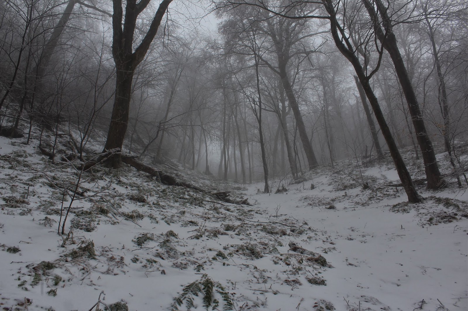
There was almost no ice low in the woods, but once I hit 1700 feet, I began to notice ice on the trees.  Once near 2000 feet, the fog grew thick and almost all the trees were covered in a thick layer of ice. 
The woods near the top of the hollow at about 2000 feet were very steep, and incredibly scenic. 
Emerging from the hollow and hitting the west ridge of Mount Raimer, with a thick layer of fog engulfing the woods. 
As I hit the ridge, I picked up a good woods road, which lead directly up to the Taconic Crest Trail. 
A coating of snow covered about half an inch(at least) of ice at this elevation. 
The woods grew eerily quiet and wintry as I made my way along the woods road.  The only sounds were the sounds of crashing ice and breaking branches.
I crossed over the Taconic Crest Trail at just below 2300 feet, continuing directly towards the summit.  As I neared 2500 feet the ice and snow grew even thicker.  The trees were really bearing the weight of the ice as well, bending almost in half.
Usually bushwhacking through hardwoods is great, unless they are covered in thick snow and ice like this.
Mount Raimer used to be home to a ski area 40+ years ago, and there are several old trails and rough ski runs that can be made out at various spots near the summit.
Pushing up on an old trail towards the summit.
A truly magical scene.
The true 2572 foot summit was literally almost impossible to stand in because of the weighted down trees.  This is a shot just off the summit.
A coating of snow draped over half to 3/4 of an inch of ice surrounded me as I tried to make my way.
Everywhere I turned was spectacular.  The ice storm really slammed this elevation.
 
With a thick fog as well as ice and snow covered trees, the scene was truly magical.  It got even better as a steady snow began falling too.
Old footings from the former ski area still remain deep in the woods near the summit.
I wandered over to a large clearing off the summit as a steady snow feell.
Dropping down an old ski run??  Shrouded in fog, it was hard to tell.
Ice and snow covered almost everything above 2000 feet.  An absolutely incredible scene.
My descent was fairly steep, as I headed through a thick fog with a steady snow falling overhead. 
I dropped deep into the hollow on my way back, slightly north of my ascent route.  At about 1700 feet, the snow and fog broke and it was all clear as I arrived back at my car.  Bare booted the entire hike, about 4.4 miles RT, with 1650 feet of ascent. A great experience and nice way to end 2019.  Happy New Year to everyone!

Saturday, December 28, 2019

Old Champlain Canal Towpath(Waterford, Saratoga County)

Took advantage of nice weather after work this afternoon by taking a short stroll along the Old Champlain Canal Towpath through the town of Waterford.  The Champlain Canal was originally built back in 1823 and connected the Hudson River here in Waterford with Lake Champlain in Whitehall.  The old towpath has been restored as a stone dust multi-use recreational trail starting at the end of Fulton Street, where a dirt road referred to as Mill Street doubles as a parking area. 
The Old Champlain Canal is very shallow and passes beneath the iron bridge crossing on Fulton Street(which you just drove over to get here), and continues north with steep banks rising straight up on the other side.
Off to my right, just downhill from the towpath was a dirt road and foot path, which I followed down to the Mohawk River.  From the water's edge, I caught a nice look towards Bock Island(left), Peebles Island(center), and Goat Island to the right.
After checking out the Mohawk, I quickly made my way back onto the towpath, which closely follows the old canal, heading north and passing by many backyards and nearby businesses. 
 
After nearly a mile, the trail bends sharply right(SE) and comes to the area around Lock 2.  The bridge carrying traffic along Route 32 onto Broad Street is visible upstream here.
 
Arriving at Lock 2, a working Lock on the Erie Canal and is also the first in the Waterford "Flight of Locks".
A nice view of the 4th Street Bridge from the end of the Lock 2 area.  The bridge would be my turn around spot for the day, as I knew I was fighting the early sunset. 
The late afternoon sun was already starting to set as I retraced my steps south back towards the car.
Once back by the parking area at the end of Fulton Street I continued south past a gate and into a grassy field and picnic area.  Just off to the right I spotted the Old Champlain Canal Lock 4 with a wooden bridge crossing over it. 
I explored the picnic area and up to the fenced in area around a large dam that crosses the Mohawk River.  I couldn't get around the fenced in area so I dropped down towards the water and caught a neat glimpse towards the tip of Goat Island and a split in the river.
Just prior to getting back into the car, I dropped back down to the Mohawk River one last time and found a small little fishing area with great water views upstream.
Got back into the car as the sun dipped below the horizon. A nice and easy, historically significant 2.2 miles RT.

Monday, December 23, 2019

Ticetonyk Mountain(Phoenicia/Mount Tobias Wild Forest-Catskills)

With a forecast for 100% sun and temps soaring to near 50 degrees, I knew today would be a great day to get out and do some exploring.  Headed down into the heart of the Catskills to explore 2510 foot Ticetonyk Mountain, a peak I had hiked previously but from a different direction.  I had been itching to re-climb this for a while, and a recent fellow blogger's trip report helped moved this trip up to the forefront.
There is access to this mountain from both NYC DEP land and NYS DEC land along Peck Road, each with their own parking areas.  Having already hiked from the DEC parking area, I would be starting today from DEP land just east of the YMCA at an elevation of about 1300 feet.  As with many of these Catskill peaks, I passed by snow covered stone walls standing stoic, rugged and handsome. 
While this hike is considered a bushwhack, much of the mountain is laced with old woods roads and paths that make for very easy traveling.  With old roads this good climbing the mountain, it might as well be a trail.
It's small things like this that satisfy the explorer in me. A frozen over vernal pond on NYC watershed land was as beautiful as it was unexpected.
On my ascent there were several woods roads and paths that branched off the road I was on, but I stayed on the most direct route up.  The woods road petered out into more of a foot path up hgih, but surprisingly continued all the way up to Ticetonyk's far western ridge, near 2100 feet.  Within moments it was clear why there is fairly well trodden path here....
...a jaw dropping view south from a clearing just off the ridge.  Many of the Catskills highest peaks rise in front of you from this vantage point, including much of the Burroughs Range.
I saw various herd paths exploring this clearing, leading to several different spectacular view points.
This was quite a spot, with a unique and pretty incredible view.
A small portion of the Ashokan Reservoir is visible with South Mountain and Ashokan High Point rising beyond.
After enjoying the views, I began my true bushwhack east/southeast towards Ticetonyk's summit, which sat just over half a mile away. The woods were very open and easy to navigate, with sparse mountain laurel scattered about. 
As I neared the summit area, I could no longer avoid the mountain laurel.  It was fairly thick in spots, but luckily I stumbled across several game paths that helped me elude the worst of laurel. 
After fighting my way through the nasty mountain laurel, I hit the summit area, with open hardwoods and very pleasant conditions. 
After hitting the summit, I dropped down towards the steep east/ southeast slopes in search of views.  I found mostly screened views to the east until I hit an open area of ledges with amazing views SE down towards the Ashokan Reservoir and beyond.  In the foreground are Little Tonshi and Tonshi Mountains.
A zoom view towards the tower atop privately owned Tonshi Mountain, which sits just below 2000 feet. 
This view=my early Christmas gift to myself!  Wow!
With temps soaring into the upper 40's, I decided to take my lunch break from this open ledge, basking in the full sunshine.  A sweeping view, stretching as far as the Taconics near the Connecticut state line was quite the reward.
After finishing my quick lunch and a drink, I decided to drop down to the near vertical southern slopes below the summit and caught interesting views down towards the large, frozen pond at the foot of the mountain as well as the dividing weir across the Reservoir.
Eventually made my way over towards a gentler descent down the peak's southern ridge.  Once below 1900 feet, I headed more SW, bushwhacking more directly towards my car.  Picked up various old woods roads along the way, leaving each of them until eventually hitting my original route up.  2 to 3 inches of firm, crusty snow early on in the day had turned to much and gloppy snow on the way down making for a couple of tricky spots.
A beautiful spring feeling-early winter day in the Catskills.  This mountain had a little bit of everything and was extremely enjoyable.  Hiked about 4.6 miles RT with about 1450 feet of ascent.
Today's route below.  Blue=Ascent   Red=Descent