Search This Blog

Thursday, September 30, 2021

Burnt Mountain(Blue Mountain Wild Forest-Adirondacks)

Sitting just east of Long Lake Village is 2556 foot Burnt Mountain, a peak that goes unnoticed by most people, rising unassumingly above the Northville-Placid Trail.  A while back I had noticed a large area of open rock near the summit while looking at satellite imagery and been itching to check it out.  Although it was cloudy and cool, I thought the fall foliage would make today a good day to give it a shot.  I parked in the designated lot for the Northville-Placid Trail, south off of Route 28N(about 1/4 mile east of Shaw Pond) and was the only car there when I arrived.  Elevation to start was 1775 feet, with a temperature hovering at 50 degrees.

Leaving the parking lot, the trail heads south, passing through wet woods on large sections of wooden planks that are extremely slick.  Use caution in this section, especially in the early morning or following a rainfall.

The blue marked trail crosses over wide and slow moving Shaw Brook before continuing on to a footbridge over Sandy Creek.

After about 1.5 miles, I left the marked trail, picking up an unmarked but good woods road heading left(southeast) more directly towards the mountain.  I stayed on this woods road for about 4/10 of a mile, including an easy crossing over Sandy Creek once again, this time without a bridge.


The woods road ends at Long Lake Reservoir, a small, dammed up body of water along Sandy Creek.

From the Reservoir I began my bushwhack east up the mountain, passing through wide open hardwoods. The ascent was not steep until about 2300 feet, where the terrain turned much steeper and the woods changed to scratchy spruce, slowing me down just a bit.

Just NW below the summit, I noticed a large swath of open rock, which was exactly what I was looking for.

I first pushed my way up to the wooded 2556 foot summit, which was marked by a small rock cairn.


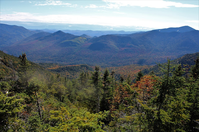
After tagging the summit, I decided to explore the many views that were available from the open rock slab.  The first(and best) view I enjoyed was the expansive northeast facing look towards the High Peaks, which were unfortunately shrouded in clouds.  The far reaching vista gave my first glimpse at the fall foliage, which was close to peak in spots from here.


Zoom view towards the High Peaks.


From a similar vantage point looking more east.


I wandered around the open rock, enjoying the nearly 180 degree views to the north, including this look towards Long Lake.

North views towards Long Lake, with Blueberry and Kempshall Mountains to the right.

I eventually made my way over to the open, south facing views towards nearby Salmon Pond East and West Peaks.  To the left, SE, sits Fishing Brook Mountain.   Even with the overcast conditions, the colors were really popping in the hardwoods.

Circling around the southwest facing open rock, with great up close views towards the colorful ridge between Salmon Pond West and Mount Sabbatis.
From the west facing slopes, the views aren't quite as open, but still nice towards neighboring Mount Sabbatis.

I dropped back down the west slopes of the mountain, meandering my way back to the NPT near the Reservoir.  From there it was an easy trailed hike back to the car.  About 5.5 miles RT for the day, with 1100 feet of total ascent.

Map below.  Blue P=Parking   Red X=Long Lake Reservoir   Blue X=Burnt Mountain summit


Tuesday, September 28, 2021

Mount Dunham(Silver Lake Wilderness-Adirondacks)

With autumn in full gear, I decided to head up into the Silver Lake Wilderness near Wells today to hike 2602 foot Mount Dunham, a trail-less peak that looked like it may have some views to offer from open rock near its top.  I parked on the shoulder of West River Road just west of Jimmy Creek where state land meets the road(Elevation 1100 feet).  From the car I headed north through open woods, soon dropping down to Jimmy Creek, which was flowing nicely following this week's rainfall.

Continued north up to a small but pretty waterfall on Jimmy Creek, crossing just above there to the east side.
The slopes above the creek were quite steep and a bit rocky, making for a slow climb up.
Once atop the steep slopes, it was a nice and easy 'whack NE through mostly open woods.  There were a couple of small ups and downs along the way which were a bit tiring as I arrived at the foot of an unnamed 2546 foot peak, which unfortunately stood between Mount Dunham and I.  Instead of wasting a lot of energy climbing over the steep slopes, I opted to skirt the west side of the peak before ascending up towards Dunham.
The woods remained mostly open all the way to Dunham's summit, where I suddenly found some scratchy spruce mixed in as well as several large rock ledges. 


A steep scramble brought me up to open rock shelf just south below the summit.

There are a couple of real good open ledges with outstanding views stretching from the SE all the way to the west.  This is the SE view, with clearing skies above.  The foliage was okay here and there, but not quite as good as I thought it would be.

To the west, across the valley of Jimmy Creek sits (L-R) Dugway and Swart Mountains.


Looking southwest at the neighboring unnamed summit with many of the peaks in the Silver Lake Wilderness beyond.

From the open ledges, it was a nice and easy ascent less than 1/10 of a mile up to the wooded, conical 2602 foot summit.

After hitting the top, I decided to explore some of the steep south facing ledges in hopes of more views.  I was able to catch one nice framed view all the way down to the Great Sacanadaga Lake, with the West Branch seen snaking its way down below.

A fairly steep descent to the south brought me back down to the saddle between Dunham and it's unnamed southern neighbor, leaving me with the option of what to do.  Should I go around the unnamed summit again or over it? I decided to go right up and over it this time to see not only what was up there, but it was also the most direct route out.  A short but steep ascent brought me up to the open hardwood 2546 foot summit.

From the wooded summit of the unnamed peak, I descended down the steep southern slopes back to my original tracks.  I basically retraced my route back to the car from there, completing a long 7 mile bushwhack with over 2300 feet of combined ascent.

Map below.  Blue P=Parking    Black X=Unnamed Summit   Red X=Mount Dunham


Sunday, September 26, 2021

Lower Wolfjaw, Upper Wolfjaw, and Armstrong Mountain(High Peaks Wilderness-Adirondacks)

Headed up north with a couple of my longtime buddies Sunday morning to knock out the Upper Great Range in the Adirondack High Peaks, which would also bring me three peaks closer to being a 46er.  We were going to approach the peaks from the Garden, but lucked out through someone else's last minute cancellation and got a spot at the St. Hubert's AMR trailhead through the parking permit system.  We arrived at the crack of dawn with temps hovering near 50 degrees and set out on Lake Road through AMR property, before crossing over the Ausable River and heading up the Wedge Brook Trail.

The trail climbs steadily, passing by several pretty waterfalls on Wedge Brook along the way.
The Wedge Brook Trail eventually leaves AMR property and hits state land as it climbs west up into Wolf Jaws Notch, with glimpses of the walls of Lower Wolfjaw's cliffs rising impressively above.
The trail arrives in the Notch at about 3500 feet, leaving a steep, but manageable 1/3 of a mile scramble up over 600 feet north to Lower Wolfjaw's summit on the W.A. White Trail.  With a light breeze and temps in the upper 40's, it was definitely a reminder that summer is long gone up here.  After a steep ascent, we arrived at the 4173 foot summit and found nice views west with clouds hanging just over the nearby mountaintops.
Summit views to the SW, with a thick overcast.
After a couple of minutes, we turned back, descending steeply back down towards Wolfjaw Notch, with good views south towards a false summit of Upper Wolfjaw directly in front of us.

From the Notch, we began our steep climb up towards Upper Wolfjaw, with clearing skies above.  In one particular spot on the climb, I caught this nice, framed view back towards Lower Wolfjaw, where we had just been.
Up and over the false summit, we soon hit the next saddle, which was loaded with dead trees and quite muddy.  We now could see the summit ridge just above us to the south.
After a few minutes of climbing we hit the spur trail, which leaves the main trail and heads 20 yards away to the stellar summit of 4203 foot Upper Wolfjaw.  The views from here were much better than we had anticipated. stretching from the NW to the south.  The north facing view, takes in Lower Wolfjaw and the false bump on Upper Wolfjaw, both of which we had just climbed.  Just beyond, to the north, sit Giant and Rocky Peak Ridge.


The incredible view east, with Round, Noonmark, Bear Den and Dial in front and Dix rising above just beyond.
The skies had cleared and the winds dropped off, so we enjoyed lunch and the views from atop the summit.  The best part of all was that we had the peak to ourselves!

From Upper Wolfjaw, we began our route over to Armstrong, dropping down to about 3900 feet before a stiff climb up.  There were several very steep parts of this trail, with ladders included.


Along the way there are several good viewpoints on the climb up Armstrong, mostly to the west and north towards Tabletop, Phelps and Big Slide.

After about 8/10 of a mile, we hit the 4446 foot summit of Armstrong, where a large area of open rock slab provides an amazing up close view of Gothics!
West views from the open summit rock across the Johns Brook valley.  Fall colors were coming along down low in the hardwoods, albeit slowly.
The view south along the great Range is simply outstanding!  Gothics looks close enough to touch, with Saddleback just beyond.

Simply stunning!  A stiff, cold breeze kept us from lingering too long, but man, the views were awesome!

From the summit, we continued over to the saddle between Armstrong and Gothics before beginning our descent.  We enjoyed amazing views of Gotchics and Pyramid Peak on the way down from several open ledges.  Absolutely breathtaking.

There are many, many good views along this trail, where a dangerous, vertical drop off can be found just a mere foot or two off the trail. This east facing view takes in the Colvin Range, Dial and Nippletop just beyond and Dix Mountain poking out in the distance.


On our descent, we passed by this cool natural feature..a HUGE balancing boulder, which would make a nice emergency shelter.

A final, very steep drop brought us down to Beaver Meadow Falls, which is really a sight to see.
The falls drop over 60 feet and are so picturesque that they look like a painting.
From the falls we headed east towards the Lake Road, crossing over the Ausable River, pausing to take in this nice view to the south.  Some of the best fall color we saw all day was along the stretch bordering the Ausable.

A long, seemingly endless road walk brought us back to our car, feeling fulfilled. Hiked about 13.5 miles RT, with 4500 feet of ascent for the day.  The AMR Permit System seems to be a success.  We only saw a few people out all day, and most of them were on Lake Road.  For such a new system, AMR seems to have a pretty good handle on things.  We were pleasantly surprised!  A great day in the woods.  (29/46)