Search This Blog

Friday, May 31, 2019

Morris Hill(Catskills)

Rising to only 2310 feet and with no marked trails to the top, Morris Hill doesn't really demand much attention from the everyday hiker.  In doing some research for another hike, I happened to notice that Morris Hill(located just north of Arkville and south of Halcottsville) is on DEP(NYC watershed land) property and according to satellite imagery, even appeared to have some open areas near the summit.  This all added up to me wanting to hike it when I had a half day free and good weather.  Friday afternoon proved to be just that.  I parked off the large shoulder of Route 30 near a Railroad crossing(just south of Kelly  Corners Road) and headed across the road to a tiny area of DEP land at an elevation of 1370 feet.  I had to pick my way through a wet, muddy area along the road before I hit the steep slopes that make up the west side of the peak.
This little peak has some very, very steep slopes and I found myself huffing and puffing within just a few minutes.  Some of the ground was damp too, meaning I was sliding on some of the steepest areas. 
Although a fairly small peak by Catskill standards, the woods and terrain took on the appearance of a much larger mountain.  Easily maneuvered my way up and around several large overhanging rock ledges along the way as well.
After climbing over 700 feet I suddenly emerged out of hemlocks into an open area of hardwoods.  Within moments I found rudimentary foot paths and some sort of rough old woods/ jeep road that seemed to circle below the summit.
 Arriving at the enormously overgrown meadow atop the mountain, where I found various foot paths wandering all around.  Thick areas of prickers were certainly a drawback as I explored.
 
A small SW view towards Kettle Hill.  It looks like I hit this peak at the wrong time of the year as views would probably be outstanding once the leaves are off the trees.
The summit experience was so unique and different that I really wanted to soak it all in and see what it had to offer.  I dropped down a bit off the summit in hopes of some clear views but found pleasant fern glades and grassy slopes instead.
The summit is so open that it grew frustrating seeing screened views such as this much of the time.  After fighting through thick prickers and picking several ticks off me, I decided that it was time to head back down.
On the descent, I poked around looking for more views and did find a couple small windows towards Hubbell Hill to the NW.
In speaking with the Catskill Mountain Club after the hike I found out that a future trail is planned for Morris Hill which is exciting news because with a little maintenance this summit could be something really spectacular.  Hiked about 2.4 miles RT(with a lot of summit wandering) and 1000 feet of ascent.


Sunday, May 26, 2019

Unnamed Palmer Pond Mountain(Hoffman Notch Wilderness-Adirondacks)

Went to check out a rarely visited peak, simply labeled 693 m on topo maps, in the Hoffman Notch Wilderness on Sunday.  While there is no given name to this peak, I've heard it referred to as Palmer Pond Mountain or North Squaw Mountain due to its proximity to those features.  Regardless of the mountain's name, it is a real hidden gem and almost directly in plain sight, towering above Exit 29 of the Northway.  The DEC created a parking area right off Blue Ridge Road just west of the Exit 29 ramp, providing access to Palmer Pond and its southern shores. 
Took a few moments to check out Palmer Pond, which sits just a short walk away from the parking area.  Elevation to start was down at 876 feet.
Continuing on, a handsomely built bridge provides easy crossing over "The Branch", which is the pond's outlet.
From the bridge, a look back over at the dammed area of "The Branch", which helped create Palmer Pond.
The jeep trail circles around to the south side of the pond for about a hundred yards, before dead ending.  That is where I began my bushwhack, and almost immediately I was climbing steeply.  I quickly realized that the black flies would be accompanying me for this hike too.
The forest changed between hemlocks and hardwoods and was quite nice to hike through.  On my ascent, I began by heading southeast over to the first set of ledges I found at about 1350 feet.  These ledges almost literally hang right out over the southbound side of the Northway, and do provide some nice views.
An early view from the low ledges, looking east towards Frontier Town.
South views from the low ledges, with a hint of the Northway peeking out.
A small drop from the first ledges, lead me to another set of impressive cliffs, which I had to find a route up.  I circled around  to the north side of these cliffs to find an easier way up.
The mountain actually has two peaks, and to climb it from the north you have to go over both summits.  Once on the main ridge of the north summit, I found the going to be quite pleasant.
Ledges ring the south side of the ridge, providing some nice views along the way.
A short distance before the north summit, I managed to find my first clear view NE back down to my starting point along Palmer Pond.  Blue Ridge Road, the Northway and Frontier Town are all visible down in the valley, with the peaks of the Hammond Pond Wild  Forest beyond.
Just below the north summit, I came across this large vernal pond.
The north summit is wooded, but just a few yards away, I did find one peek a boo view toward the south summit, which was my main goal.
A small drop and re-climb brought be up to the south summit, where I was almost overwhelmed with spectacular views.   Although only 2274 feet, this small peak, more than makes up for whatever it lacks in stature with incredible views from the mostly open summit area.
To the south, the Northway can be seen winding along, with a small section of Schroon Lake also visible.
The pine and rock summit area that makes this such an incredible place.
From the summit, you are afforded an up close and personal view of Hoffman Mountain(L) and Blue Ridge Mountain(R), which tower impressively to the SW.
To the north, many of the High Peaks are easily visible.
A look NW towards Blue Ridge Road, with the Adirondack Buffalo Farm in the clearing along the road.
A zoom view south towards I-87 and Schroon Lake.
A zoom view to the west, where Blue Ridge Road snakes its way between the peaks.
After enjoying the summit views, I finally headed back down, heading in a more direct line to the car on the descent.  I tried to keep a good move on to avoid the worst of the black flies.  Hiked about 5.5 miles total with over 1600 feet of total ascent.

Tuesday, May 21, 2019

Grandpa Pete Mountain & Sunrise Mountain(Elk Lake Lodge Property-Adirondacks)

When you get an invite to not only hike a private property mountain with reputed great views, but to also partake in your hiking buddy's completion of the Adirondack Hundred Highest list...you jump at it!  I found myself in this extremely fortunate situation on Tuesday with my friends, Jim, John, Spencer and Correne, as we would be using exclusive access to hike on the property of the breathtaking Elk Lake Lodge.  Since we had multiple cars, we chose to make this a part trail/ part bushwhack traverse hike to see as much area as we could. Our starting point was a spot just south of Clear Pond along Elk Lake Road at an elevation of about 1850 feet.  After a short road walk, we dipped into the woods on the Old Military Road(which is actually now a trail) which follows the NW shore of Clear Pond.  We found a small view just off trail across the water towards our first destination..the open rock atop Grandpa Pete Mountain.
One of the nicest parts of hiking private trails is that they are usually in immaculate condition when compared to the much more heavily used public trails.  Solid, well constructed foot bridges also help keep feet dry, such as this crossing of Clear Pond Inlet.
Within a few minutes, we arrived at Jones Beach, a quiet little beach tucked into the NE corner of Clear Pond. The multiple northern summit bumps of Ragged Mountain can clearly be seen to the SW.  Wolf Pond Mountain and Boreas Mountain, much larger peaks and slightly to the right, were unfortunately buried in thick fog so barley visible.
A cold, light rain was falling on us at Jones Beach, so we quickly continued on, heading back into the woods and ascending Grandpa Pete Mountain, which, at just under 2400 feet, is really just a small sub peak of Clear Pond Mountain.  As the trail nears the top, it circles beneath a set of impressive rock ledges, rising nearly 20 feet up.
A stiff climb up to the top of the ledges, brought us to our first views of the day.  Fog and mist obscured the views a bit, but it was still a nice spot. Here are SE views towards Three Brothers Mountain, also on Elk Lake property.
The best view on top of Grandpa Pete Mountain was the view directly down over Clear Pond.  A careful eye can even catch a small rainbow across the pond.
After enjoying the views for a few minutes, we pressed on, dropping back down on the trail below the summit ledges.  Once below there, we began our bushwhack north-northeast towards the next peak, an unnamed 2800 foot south summit bump of Sunrise Mountain.  A drop back down below 2000 feet got us into the col, before a steady, steep climb got us up to open rock slabs on the SW slopes of the peak.  Luckily for us, just as we hit the open rock...the skies began to clear...and the sun emerged. 
Clearing skies allowed for our first good views of the day from the open rock slab, and boy were they impressive.  The view SW towards Clear Pond was amazing!  The many surrounding peaks began to emerge as well.  To say the least, we all were quite excited about what laid ahead.
Looking back south at the route we had just come from, with Grandpa Pete Mountain in the foreground of Clear Pond Mountain.
As we continued to climb, we continued to find more and more open rock, with spectacular views.  Soon, the only spot left with the clouds hanging on was to the NW beyond Elk Lake, towards the High Peaks.
Circling around the open rock to the east side of the mountain, we managed to find this east facing view of Niagara Mountain. 
A steady 200 foot drop brought us back down below 2600 feet, before we had to begin our steep climb up 3614 foot  Sunrise Mountain. What we did find on our climb up was a ton of open rock and even more great views...these being even better than the ones before!!  From just under 3000 feet, this open rock slab provide south facing views towards Hoffman Mountain and Blue Ridge Mountain.
Emerging at one of the best vistas I have found anywhere.  Nearly 180 degree views at 3400 feet.  Here is the view SW over Clear Pond towards many, many of the Adirondack peaks.  Outstanding!
Group photo!
Spencer takes a moment to check out this rock perch.
The incredible view west over Elk Lake towards the southern end of the Colvin Range. 
Proving that this far north, and at this elevation(just under 3600 feet), winter holds on tight.  Yes, a small section of rotten snow.
While much of the bushwhacking was remarkably easy, the final 2/10 of a mile was through a lot of deadfall as well a much thicker section of spruce, very typical of the Adirondack Hundred Highest peaks.
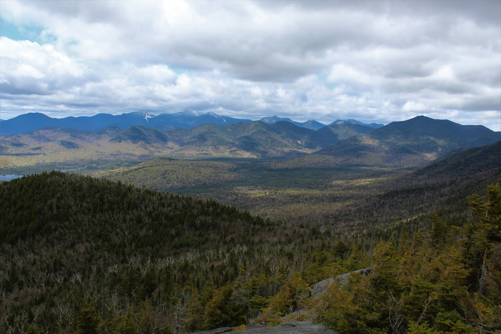
A final, steep push got us up to the summit, where we also ran smack dab into the trail.  The summit views were even better than I had imagined!!  The view towards the High Peaks, with the highest peaks still capped in white.  The Great Range is seen here, just behind the Colvin Range.
The north view towards the Dix Range and Nippletop!!  That's Macomb rising above the treetops in the foreground.
For my buddy Jim, this capped his quest for climbing the Hundred Highest Adk peaks.  In his own words, this was the list that he was most proud of.
Another look down towards Clear Pond.
Zoom view towards the Pinnacle, Blake and Colvin, with Skylight, Marcy and Haystack beyond.

Changing skies made for amazing views of the High Peaks. 
The sun poking out atop Marcy's snow capped summit for just a moment. 
A last look at Elk Lake before the bitter summit winds chased us back down the mountain.
A fairly uneventful trail hike brought us back down off the mountain(and a couple more view spots), before we eventually met up with the state trail towards Elk Lake Road.
What a great day and a spectacular adventure in an area that very few people get to see!  Hiked about 8.5 miles total with over 2000 feet of ascent.