Search This Blog

Friday, February 26, 2021

Hackensack Mountain(Hackensack Mountain Park and Recreation Area(Adirondacks)

Headed north after work this afternoon to re-visit 1357 foot Hackensack Mountain, a small peak located just off Exit 23 in the town of Warrensburg.  Bluebird skies and comfortable temps in the mid to upper 30's were the recipe for a great day in the woods.  I have climbed this mountain a couple of times before, but it has been a few years, so I thought today would be a perfect chance to go back.  There are two separate trailheads, but I opted to park at the northern access point along the shoulder of Hackensack Ave, elevation 780 feet.  I threw my spikes on because I figured the trail was very well packed down(and it was).  Conditions were perfect, and as hard as it was to believe, I was the only car there.

Bright sunshine shining through a handsome stand of conifers.
Frosty?
After a steady climb up, I soon hit the large clearing near the summit.  Spectacular views can be found here with many photo opportunities.  Here is a NW view towards Crane Mountain. 
The views are simply stunning, stretching nearly 180 degrees.  The streets for Warrensburg lay directly below at your feet, and the Three Sisters(Bald, Middlle, and Pine) rise to the left, with Sugarloaf to the right.

Just past the large clearing and viewpoint is the 1357 foot summit.

Continuing on over the summit, the trail drops just a bit to an informal side path and lower view point just above the hamlet.  This spot is well known as the Flag Pole viewpoint. 

East views along the orange trail.

After a steep drop off the east side of the mountain, I continued on to a yellow marked trail over to a large frozen beaver pond. 
Took a series of trails back to the car.  Was shocked to have the mountain and trails completely to myself!  3 miles RT and over 900 feet of climbing on a picture perfect late winter day.
 

Wednesday, February 24, 2021

Kinderhook Creek Preserve(East Nassau, Rensselaer County)

Did a short after work walk at the Rensselaer Land Trust's beautiful Kinderhook Creek Preserve on a beautiful winter's day.  With temperatures climbing up and through the mid 40's , I had to take advantage and get some fresh air.   Took several different trails which were in various states of melting/icy/slushy.  Nearly all of the trails here are wooded and many are heavily covered in hemlocks so winter conditions persist here longer than surrounding areas.


As always, the centerpiece of this preserve is the Kinderhook Creek, which looked as good as ever, coming out of its deep winter sleep.

Hiked a touch over 2 miles on a spring fever type of day!

Saturday, February 20, 2021

Holt Preserve(New Scotland, Albany County)

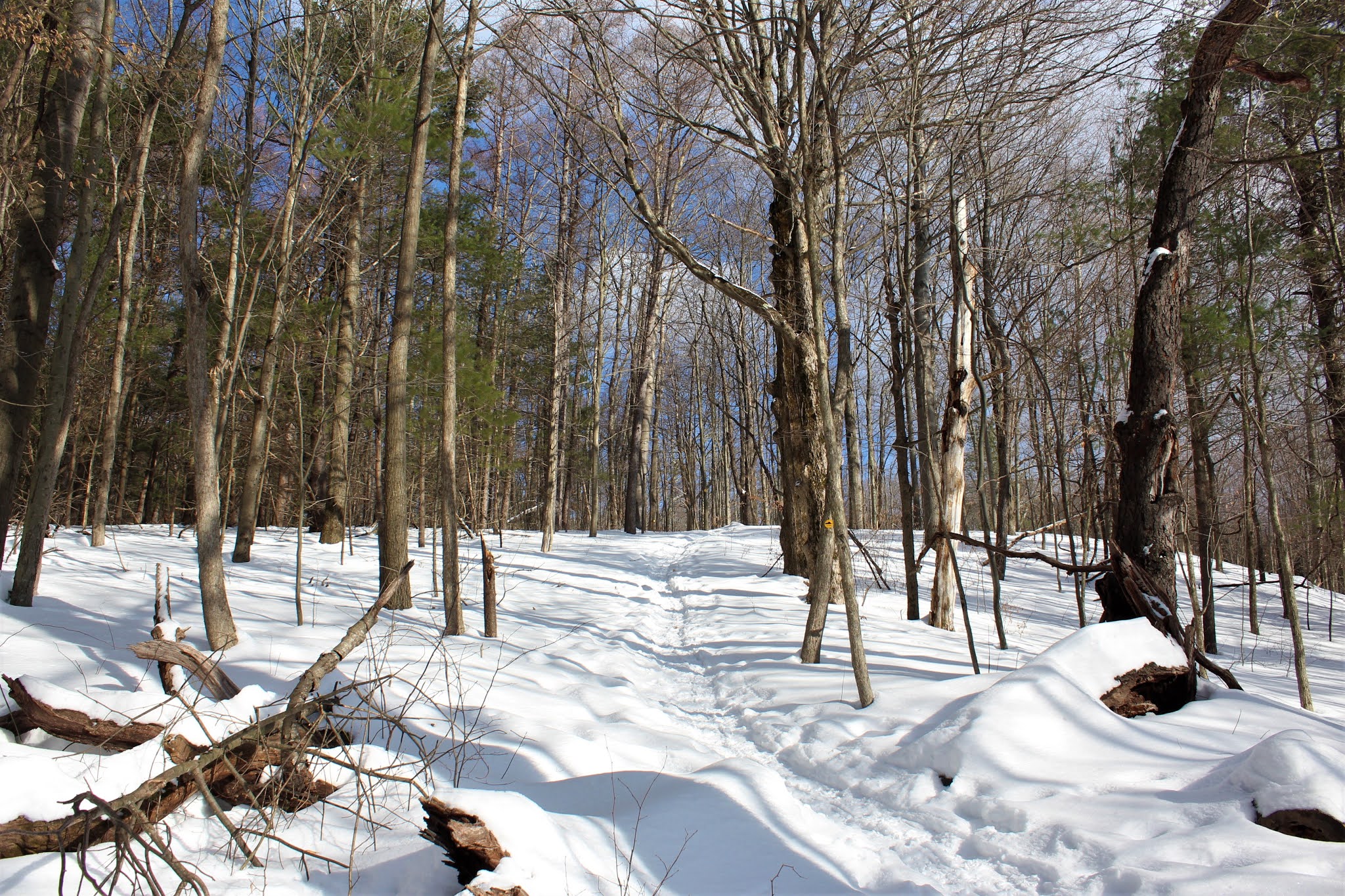
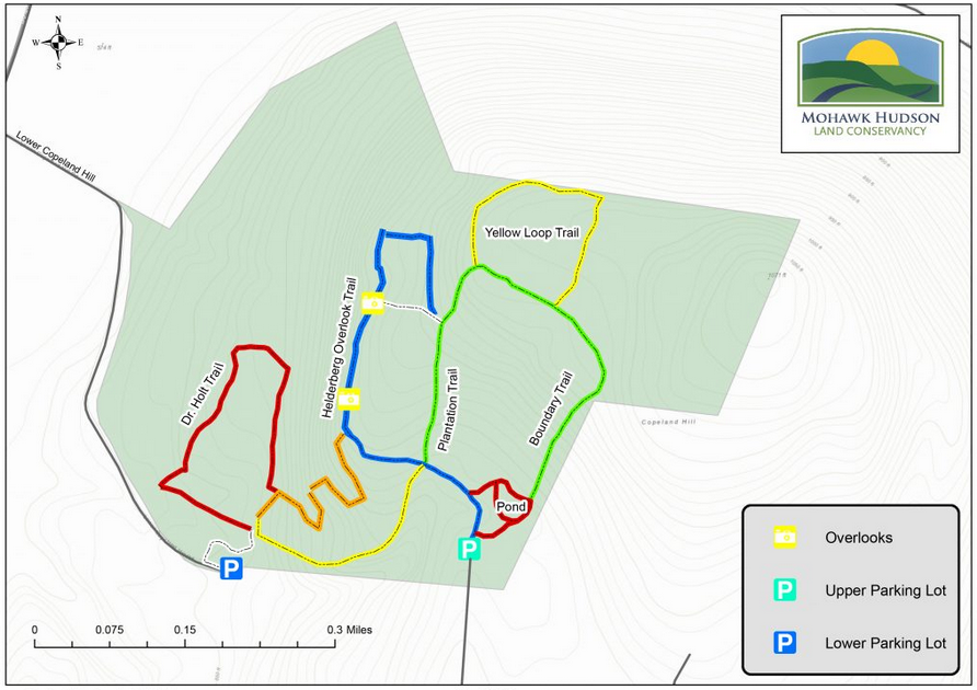
Paid a late afternoon visit to the Mohawk Hudson Land Conservancy's 148 acre Winifred Matthews Holt Preserve to get in a little snowshoe hiking today.  Parked at the winter entrance on Lower Copeland Road and headed out, elevation 650 feet, under mostly sunny skies.  Took the white trail from the road, where it enters the woods and quickly comes to a handsome wooden footbridge.

Just a couple minutes in, I picked up the yellow blazed Ravine Trail, which steadily climbs above a small stream bed and woods road down below.
Although there was a bit of a windchill, the conditions were near perfection.  A nice snowshoe trench made for easy going.
Climbed up to the blue blazed Helderberg Overlook Trail, where there are aptly enough some nice views to the west to be had.  The Conservancy has done some solid work creating these views since the last time I had visited back in 2019.

 A short distance further, I hit View #2, which is equally nice.


Even where there aren't cleared view points, peek a boo views can still be found from the steep west facing slopes.


Continued up to the green blazed Plantation Trail, which is highly scenic and passes through gorgeous conifers as it heads north, then east. 

Decided to leave the green Boundary Trail and bushwhack up to Copeland Hill's summit.  From where I left the trail it was less than 2/10 of a mile up, but the snow was deep and made it more challenging than it would have otherwise been.  The summit sits almost directly on the edge of public land, where signs are aplenty.
The wooded 1072 foot summit of Copeland Hill is actually pretty flat. Surprisingly, it looked like there were other snowshoe tracks up here, that had long been covered by new and drifting snow.

After hitting the summit, I bushwhacked back down to the green marked Boundary Trail, then continued south to the snow covered pond along the red blazed trail.

From the pond, I headed back west on the blue trail then on over to the orange blazed trail, where it makes a sharp left hand down the steep west slopes, utilizing a couple of switchbacks to ease the descent.
Back down low, I took the red marked Dr. Holt loop, with the late afternoon sun slowly fading behind the trees.
Hiked a touch under 3 miles total, with over 700 feet of ascent on a gorgeous winter afternoon.  Even on a blustery, cool day there is a subtle feel that spring is on its way.  Maybe just wishful thinking...for now I'm enjoying the great snowy conditions.


Monday, February 15, 2021

Thacher Park south of Beaver Dam Road(Albany County)

Decided to do a short and easy little hike this morning in the southern section of Thacher Park, where more snowmobiles tend to be on the trail than hikers.  I parked at the west parking lot on Beaver Dam Road(a short distance before Bush Road) and crossed the road heading south.  I carried my snowshoes, but ended up not needing them at all, as the trail was completely packed down by snowmobile tracks.  Might as well have been a paved highway!  Elevation to start was 1355 feet, as I followed the old Long Path, where some blazes can still be seen on trees.


As I headed south, some of the broadcast towers along Pinnacle Road could be seen rising above the nearby ridgeline. 

The trail is pretty straightforward and soon comes to a steeper spot where the tracks are split by a stand of conifers.  This spot, especially in the dead of winter, looks more like a ski slope than hiking trail.
Near the top of the large clearing, a Lean To sits unassumingly a few yards into the woods.  This spot is about 3/4 of a mile south of the parking area.
This looks like a well known hang out spot with a ton of beer cans filling a trash can.  Thankfully, there is no graffiti or trash lying around that I could see, so it looks like all are respectful.
Just past the Lean To, a rough outhouse sits in the woods.  Looks like it could use a little TLC.
Back on the snowmobile tracks, I headed up to the high spot on state park land, at roughly 1696 feet. The woods here are quite steep but there were still snowmobile tracks to follow, making for an easy ascent.  I did step off the beaten path in a couple of spots and the snow was easily knee deep. 

Turned around at the high spot and headed back to the car as a steady light snow began to fall.  A good stretch your legs, nice and easy 1.6 miles RT.  Didn't see anyone until I got back down to Beaver Dam Road, where several locals were out walking their dogs on the trails north of the road.

Friday, February 12, 2021

Bennett Hill Preserve(New Scotland, Albany County)

Rising prominently above the hamlet of Clarksville in the town of New Scotland is 1135 foot Bennett Hill, whose summit ridge can easily be reached via the Mohawk Hudson Land Conservancy's trail system at the 155 acre Bennett Hill Preserve.  I have climbed these trails on numerous previous occasions and it never fails to impress me.  As I headed out late this afternoon, the skies were overcast and the temps were in the upper teens with plenty of snow to snowshoe in.  I parked at the trailhead along Bennett Hill Road and saw two other cars there when I arrived, but never saw these folks on my hike.  

The green trail starts at about 720 feet, just north of the summit, and heads south along the edge of cow pastures and scenic farmland.  It must've been feeding time when I passed by today.

Views across the farmland towards the Helderbergs are your companion for the first part of the hike.

Once in the woods, the trails are well broken out and make for fun, easy climbing.
Directly beside the green trail is the iconic Bathtub Springs, where fresh water flows from an underground pipe into an old tub.
After a little more climbing on the green trail, you will soon arrive at the yellow trail, which explores the summit ridge of Bennett Hill.  Screened views(especially during the winter) can be enjoyed from this elevation.
From a small window at the north edge of the summit, there are nice views to the north above Clarksville.  The slopes below this spot are very, very steep.
From the same vantage point, looking slightly more to the NE.
The summit ridge is mostly a level plateau and consists of pretty areas of oak and red pine, as well as a small wetland, which sits off trail.
Took the yellow blazed trail over to the red trail, where filtered views can be enjoyed on the descent off the steep NE slopes of the peak.  After a switchback, the trail angles all the way back around the north and west slopes, just below the near vertical ledges of the summit ridge.
I absolutely love this small stretch of the red trail that passes through a picturesque paper birch stand.

Followed the red trail back to the green trail, which dropped me all the back down to the car.  Hiked about 3.2 miles RT with a bit over 400 feet of climbing.


Monday, February 8, 2021

Keleher Preserve(Berne, Albany County)

Headed into the Alabany County hills this afternoon to hike the Mohawk Hudson Land Conservancy's 447 acre Keleher Preserve located on Gulf Hill Road in the town of Berne. Elevation was 1500 feet at the trailhead and the sun was shining, but the temps were struggling to even hit 20 degrees at this elevation.  Oh yeah, and there was a lot of snow...A LOT.  

 I started on the white trail "west", which actually heads more north before swinging east.  Snowshoe conditions were ideal on a well trodden trail.

The white blazed trail eventually heads towards the northeastern slopes of Wolf Hill's summit area, where  there are screened views north and east from the steep slopes above the valley of Route 85 and Osequethaw Creek.After about 1.7 miles I came to spot called the America Juncture, where aptly enough, the red, white and blue trails all converge.

I opted to take the red "Overlook" trail which hugs the very steep escarpment on the east side of Wolf Hill.
There aren't exactly million dollar views from the Overlook trail, but there are decent views to the east.  One small spot in particular does offer up an unimpeded vista, where the Albany skyline can be picked out.
After enjoying the steep slopes along the red trail, I picked up the white trail again, but decided to turn back NW slowly climbing towards the blue blazed trail.  From the blue trail, which comes near but not quite to the summit of Wolf Hill, there are many through the trees views to the east.  The snow is quite deep up here too, but the trails are all broken out making for great hiking.
The blue trail heads SW for about a half mile heading through a gorgeous high elevation mixed forest. 
From the blue trail, I hit the white trail "east", and followed it all the way back to the car.  Hiked about 3.2 miles RT on a cold, but beautiful mid winter day.