Search This Blog

Wednesday, March 30, 2022

Exploring Roundtop Mountain's North Slopes(DEP/ Kaaterskill Wild Forest-Catskills)

Decided to do a little exploring in the seldom visited north/ northwest woods on 3440 foot Roundtop Mountain in the Kaaterskill Wild Forest on an overcast but comfortable early spring afternoon.  Having already bagged the summit in a previous visit, today would really just be an opportunity to see what was out there and maybe get a bonus view.  I parked in the first DEP parking lot on Gillepsie Road(Elevation 2250 feet) and then walked the road for a short distance to where DEP property comes in from the north to begin my bushwhack.


There was just some scattered snow on the ground in the south facing open hardwoods, but the recent cold spell has really built up some impressive ice.

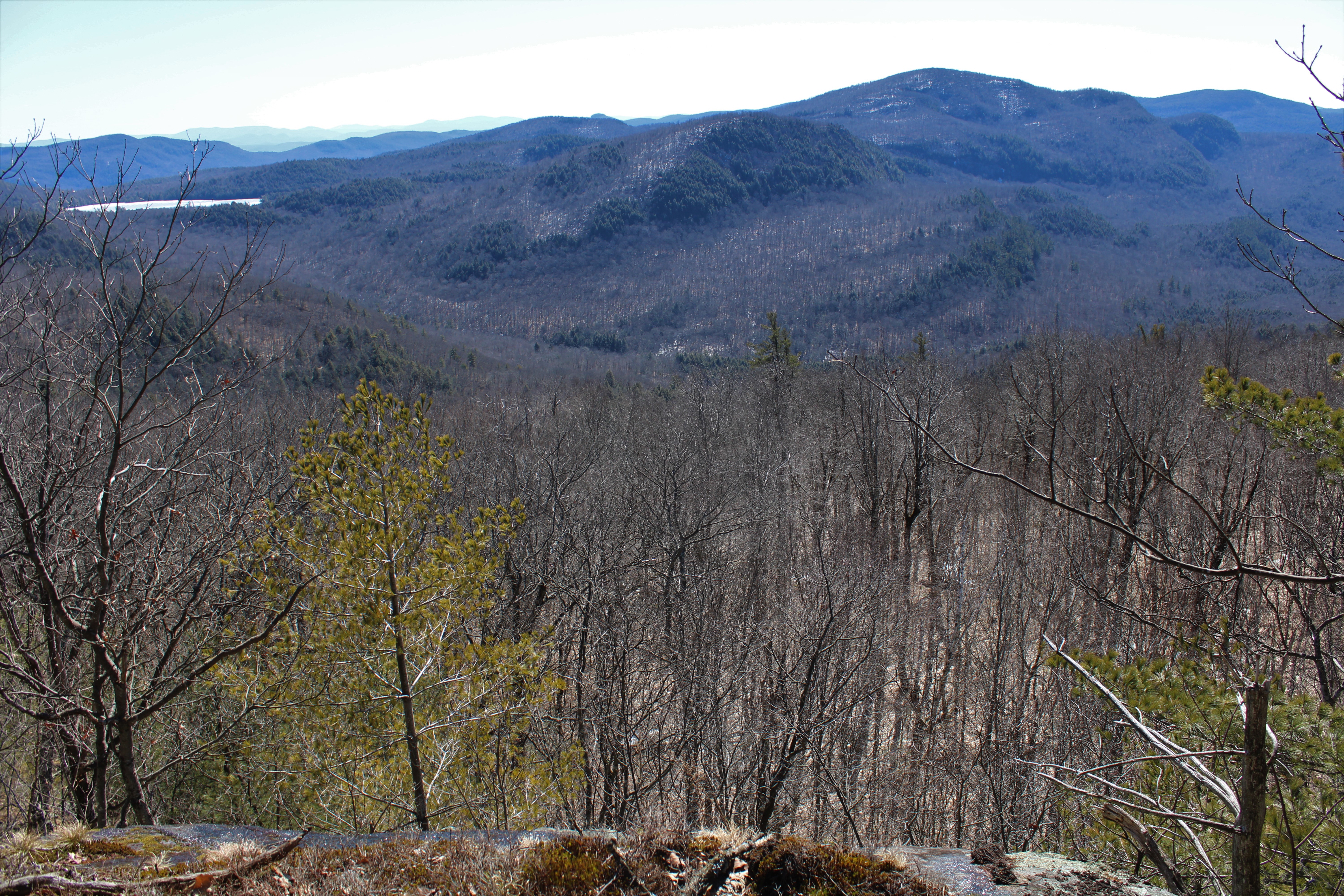
Just past the point where DEP land becomes DEC land, around 2520 feet, there is a very large band of cliffs to negotiate.  Not anywhere near the toughest cliffs I've had to climb, however, as I easily found a way up.  Once atop the cliff bands, I was able to garner some pretty decent views towards the Devils Path peaks to the south. 

I continued a slow and easy ascent NE from there, crossing over the Kaaterskill Snowmobile Trail before hitting a deep, dark conifer forest near 2700 feet.  Once I hit the conifers, the woods became much more wintry, with an inch or two of snow on the ground and any running water frozen solid.


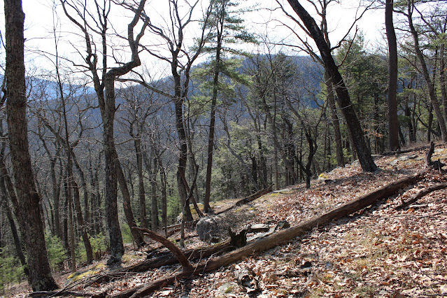
Continuing on, I kind of aimed NE, dropping slightly to a large, meadow like area near 2650 feet.  Was kind of surprised to not see any rock cairns or fire pits in this unique little spot. 


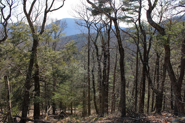
After poking around a bit further NE, I finally decided to turn around and head back west along the steep north facing slopes.  Although the terrain is quite steep in spots, it also very rugged and icy, making it tough to explore.  I was hopeful for some views and was able to get some screened shots towards the Blackheads(seen below) and even the ski slopes on Hunter Mountain from a different angle. The views were actually a little better than these photos would indicate. 

After following the north ledges for quite a ways, I finally headed back south towards the car, completing a short but sweet little exploration on Roundtop Mountain's north slopes.  Hiked a little over 3.5 miles RT, with 800 feet of total ascent.


Tuesday, March 22, 2022

Beech Mountain(Lake George Wild Forest-Adirondacks)

Headed north into the Adirondacks to tackle 2067 foot Beech Mountain, a trail-less little peak tucked into the rugged hills east of Brant Lake on a beautiful mid week day.  To access this peak, I parked at the north end of seasonal Fly Brook Road, where it meets Route 8(Elevation 1540 feet) and then set out on foot, heading south on Fly Brook Road.  The road is used as a snowmobile route in the winter months but there was more mud than snow for my first hike of the spring.  Bright sun and crisp air set the mood for a brisk walk past private camps and logging roads.


 As I slowly gained elevation, I began to hit some large stretches of snow and ice.


Nearly two miles into my hike(and now on state land) I encountered a sprawling, picturesque beaver pond at the foot of Beech Mountain(out of frame to the right).

Just past the beaver pond, the road crosses a small brook, which is somewhat easily crossed.

Beyond the brook crossing, the road continues south, but I decided to head into the woods here, beginning my true bushwhack up the steep, rocky west slopes of Beech Mountain.

A steep but fairly brief climb brought me up to small area of cliffs near 1800 feet, with decent views to the south and southwest.  A small portion of Northwest Bay on Lake George is even visible from here.

After carefully maneuvering my way along the cliffs, I continued my ascent, steering towards the south slopes of the peak, which were much more open and sun bathed.


The south slopes below the summit area are a joy to explore, with some really nice views to be found.  Almost immediately I was able to find this nice view south towards Lake George.


The best view of the day was from an open ledge facing south/ southeast towards Jabe Pond(left) and monstrous Catamount Mountain's broad profile.

A few yards away from the previous shot, this shot takes in the mass of Catamount with Lake George to the right.
After enjoying the substantial views, I continued the short distance up to the summit area, which was also quite open and marked by a small rock cairn.


While the views from the summit are not completely open, they are nice and unique compared to the earlier views, because they face NE, taking in northern Lake George near Ticonderoga and into the peaks of Vermont in the distance.


After enjoying the summit area, I headed down off the mountain, trudging through some deeper areas of snow on the north facing slopes.  I carefully weaved my way back down off the steep slopes to another section of Fly Brook Road, which I followed back to my original route and eventually my car.  With the leaves still off the trees, I was able to enjoy some nice views of the surrounding peaks along Fly Brook Road.

A nice and easy 6.5 miles RT, with 1400 feet of combined ascent for the day.  Didn't see another person all day in a quiet little corner of the Adks.

Map below.

Red X=Open view points to the south


Friday, March 18, 2022

Beetree Hill & Roundtop Mountain's Ledges(DEP Land-Town of Woodstock, Catskills)

Took advantage of a 70 degree, spring fever type afternoon by heading down to the Catskills to hike a couple of obscure peaks that were sure to provide solitude.  I would be utilizing DEP land off of Baker Road in Woodstock to hit 1821 foot Beetree Hill as well as the south slopes of neighboring Roundtop Mountain(not one of the 100 Hundred Highest Roundtops) to where public land meets private land.  I parked in a small designated parking area off of Baker Road(Elevation 1080 feet) and headed out, following a very good woods road east, then north up Beetree's slopes.

The woods road eventually peters down to a foot trail that seems well traveled, although not marked.  The woods on Beetree were remarkably open and pleasant.
High on the ridge, I began to get filtered views to the east as well as some nice stone work.
After about 1.3 miles, a short bushwhack off the herd path brought me up to the wooded 1821 foot summit of Beetree Hill.
Once I bagged the summit, I turned back, retracing my steps south to about 1500 feet, where I once again left the path and began my bushwhack west towards Roundtop.  From near the property line, I enjoyed filtered views south towards Tonshi and Ticetonyck. 
Directly west sits Roundtop, my next goal, now easily visible through the trees.
Ticetonyck is truly a giant among the many smaller peaks surrounding it.
Although Beetree and Roundtop are not very big peaks, the terrain is quite steep.  From some near vertical ledges on Beetree's west slopes, Roundtop towers above.
The drop off of Beetree Hill is a bit tricky and a little challenging due to steep slopes, slick leaves and staying on DEP land.  Down in the draw between the two peaks, there are a couple of stream crossings where properties converge near 1200 feet.  This is the trickiest spot of all to stay off of private land, but the water crossings were no issue.
Another rock hop crossing over a drainage. 
From the stream crossing, I passed over a couple of good woods roads on my way up to Roundtop's steep woods.  I contoured a bit south to where the terrain is a little more forgivable and slowly made my ascent.
I scrambled my way up on the slick leaves and was able to find some nice through the bare tree views to the SE.  Just a little further up the steep slopes, the views really, really opened up-but unfortunately they were all on private property-so I had to settle for the screened views.

From the south slopes of Roundtop, I backtracked NE towards Beetree Hill, where I eventually picked up the herd path once again, following it back to the car.  Hiked about 4.7 miles RT, with 1600 feet of total ascent on a beautiful late winter afternoon.

Map below.  Blue P=parking   Red X=Beetree summit   Blue X=Roundtop Ledges


Tuesday, March 15, 2022

Shatterack Mountain(Town of Russell, Massachusetts)

Followed the weather forecast today and headed southeast into southern Massachusetts to check out 1145 foot Shatterack Mountain, which sits just NW of Tekoa Mountain, a peak I had hiked back in November.  From what I could see, it appeared that Shatterack had a lot of open rock and views to offer so I thought it would be a fun little mountain to explore on a mostly clear, 55 degree later winter day.  I parked in an unmarked pulloff near the junction of Carrington Road and Station Road, just east of the Westfield River(Elevation 290 feet). I picked up a white marked trail that starts off pretty inconspicuously as it climbs steeply into the woods.


Once on the trail, it is obvious and easy to follow.  It is, however, an unmaintained trail, so there are at times white or blue blazes, and other times no blazing.  The trail heads SE, gaining elevation at an angle up onto the main ridge.  Once on the ridge, the trail swings sharply to the north, with splendid views to be enjoyed through the bare trees.

The mountain may be small in stature, but its slopes are steep, and I found some real nice off trail views directly west over Main Street in Russell and the Westfield River directly below.


It seems that this mountain is well known and used by locals, as painted rocks(such as this below) are a common scene on this ridge.

The views from Shatterack's ridge are quite nice, and quite numerous as well!  SE views with Tekoa Mountain dominating the scene to the left, with Route 20 and the Mass Pike down in the valley below.


NW views can also be enjoyed, following the valley of Route 20 and the Westfield River into the hills of Hampden County.


After all of the fireworks along the ridge, a quick drop and then re-climb brings you up to the open and flat 1145 foot summit.


A view just below the summit to the west.

I continued a little bit past the summit, where the trail actually widens into an old road, where there are even more views to the north to enjoy.  The snow here was sparse, as this little spot near the summit was one of the only spots I saw any today.
Retraced my steps back off the mountain and to the car, stopping to check out a couple of additional other views off trail.  A nice little 3.3 miles RT, with just over 1000 feet of ascent.


Thursday, March 10, 2022

Albany Pine Bush-Rensselaer Lake to Rapp Barrens Loop(Albany County)

Got out and enjoyed a short and easy loop hike at the Albany Pine Bush starting from Rensselaer Lake(Six Mile Waterworks Park) on a slowly improving weather day.  With skies clearing and temps  climbing above 40 degrees, yesterday's snowfall was quickly disappearing as I walked.

A light breeze and sunny skies made for very pleasant conditions as I made my way west to the Rapp Barrens Trailhead on Lincoln Ave.


Circling back to Rensselaer Lake near the Northway overpass, with the snow and ice receding before my eyes.


A very nice 2.4 mile loop, and only saw a couple other folks out enjoying the day.

Tuesday, March 8, 2022

Gutierrez Family Forest(Town of Stephentown, Rensselaer County)

Did a short walk at the Rensselaer Plateau Alliance's new 65 acre Gutierrez Family Forest located just past the Robert Ingalls Preserve on Garfield Nassau Road in rural Stephentown on a sunny but cool and breezy afternoon.  There is no formal trailhead or parking area so I simply parked on the shoulder of the road and walked down to a kiosk and the start of the Bobcat Loop Trail. (Elevation 985 feet).

The trail is well marked and easy to follow, meandering through a dark, mixed forest and along old stone walls.
The highlight of the trail is where it skirts the edge of a very large wetland, with several pleasant spots to take in water views with the nearby hills as a backdrop.
All in all, it is a nice, new addition to the RPA family of trails, with total mileage just under 1 mile.  Appears that this forest, however, is still in its infancy phases with lots of room to grow more trails.


Friday, March 4, 2022

Robert Ingalls Preserve(Town of Stephentown, Rensselaer County)

Did a short after work walk at the Robert Ingalls Preserve along the banks of Black Brook in Stephentown on a brisk but sunny late winter day.

Trails were well packed down and footing was good as I hiked about 1.5 miles total.
 

Thursday, March 3, 2022

Schaghticoke Mountain(Kent, Connecticut-Litchield Hills)

Did a quick out and back hike today along a section of the Appalachian Trail up 1330 foot Schaghticoke Mountain along the NY/ Connecticut border on a cool but sunny late winter afternoon.  I got started from the parking lot for Bulls Bridge(Elevation 350 feet), which is a well known covered bridge that crosses the Housatonic River.

The rough and tumbling falls on the Housatonic just below Bulls Bridge.

From the bridge it was a short road walk on Bulls Bridge Road and then onto Schaghticoke Road, which actually doubles as part of the Appalachian Trail for about 3/10 of a mile.  The familiar white blazes of the AT head west into the woods and then climb steadily up the east slopes of Schaghticoke Mountain.  There was some spotty snow here and there on the trail but nothing of real consequence. 

Straddling two different states.

After roughly 2 miles of hiking I hit an open south facing viewpoint towards Ten Mile Hill(left) and Gardner Hill(right).  This is a great spot to take in the views.
From the same viewpoint, looking east into rural Connecticut.
Same vantage point, with Leather Hill now visible to the far right.

Just a few yards off trail from the lookout, I found some additional decent views to the west/ southwest as well.

With the clock ticking on the remaining daylight I skipped hitting the summit and turned back at the viewpoint, quickly dropping back down off the mountain and passing by handsome old stone walls on the way.

A nice and easy road walk me back to the car in no time.  About 4 miles total with a bit over 1000 feet of ascent. 

As I started my ride home, I caught this nice glimpse of part of Schaghticoke's south profile rising above the meadows below.