3140 foot Overlook Mountain is quite possibly one of, if not the busiest trails in all of the Catskills and deservedly so. An easy climb up an old carriage road, beautiful mountaintop views, old hotel ruins, a firetower and cabin...this mountain has it all. The part of the mountain that has always intrigued me the most, however, is the steep east face of the peak, where a small public easement on Lewis Hollow Road does allow hiker access to state land higher up. The east side of Overlook Mountain is one of the steepest areas in all of the Catskills, and its nearly vertical rocky profile has earned it the name the Minster's Face. We spotted a car at the traditional trailhead along Meads Mountain Road, and then drove down to Lewis Hollow Road to get started on our traverse up the Minster's Face and eventually onto the summit. Elevation at the small easement is 950 feet and a sign instructs the explorer to stay on the old woods road until arriving at DEC land.

We got started by crossing this unnamed brook on a beautiful June morning with a light breeze keeping the bugs at bay.
The old road climbs moderately at first, up through an old quarry before coming to a stream that drains the east slopes of the mountain. Our wet spring provided several picturesque falls along the way.
The pretty drainage we followed on our ascent through Lewis Hollow.
We stumbled upon this old hunting campsite lost in the steep terrain of Lewis Hollow.
As we gained elevation, the slopes became much steeper and filled with loose rock. Hidden within these jumbles of loose rock we were told...are rattlesnakes. So we proceeded with vigilance, stepping lightly and carefully.
Emerging from the forest canopy at about 2300 feet, we first laid eyes on the Minister's Face. Very impressive!!
The loose rock below the Minster's Face made for very slow going, as we cautiously ascended.
Suddenly, almost without warning, Jim saw a rattler!! This guy meant business too, as he rattled away to keep us away.
We were both stunned and in awe at the sheer size of this snake.
This snake didn't seem to want us around as we kept rattling for several minutes, as we gently made our way around him....giving him a wide berth.
There is almost no safe route directly up the face, so we slowly made our way north, picking our way through the jumbled piles of rock...watching each step VERY carefully.
While the rattlesnakes had us "rattled", the surrounding views were drop dead amazing. The valley floor literally drops away from this vantage point. This is a south view towards the Ashokan Reservoir.
As we made our way around the face, we enjoyed a nice view of the steep face.
Almost every route up was filled with some form of danger...loose rock on steep slopes, or rattlesnakes hidden between the jumbled rocks. Just when we thought we were safe, we spotted two more rattlers, both rattling and agitated and both way too close for comfort! We quickly(and safely) made our way out to the rocks and back into the hardwoods.
Once into the hardwoods, we relaxed a little bit, but still paid very close attention to where we stepped, as we arrived at the bottom of the Minister's Face. This was a long flank to the right(north) around the vertical walls, until we found a small, steep chute up.
A very steep, hands and knees climb up the chute brought us up to the far north side of the face. From there, just above the surrounding tree tops, was a spectacular view towards Plattekill Mountian and Codfish Point.
The woods were absolutely gorgeous and teeming with life. Mountain Azeleas were on full display, showing off their brilliant blossoms.
Edging along the steeps near the top of the Minster's Face, we managed to find this small ledge that provided an up close and personal view of the rocky prominence itself.
After clawing and climbing to the top of the Minster's Face, we finally sat down to enjoy a much needed break, and some jaw dropping views of the Hudson Valley.
Once atop the Minister we thought it would be easy...only to run into thick mountain laurel much of the way up the remaining half mile to the summit.
Arriving at the herd paths and marked trails along the summit was a welcome relief after the blood, sweat and tears it took to get here. It didn't hurt that conditions couldn't have been much better.
The clifftop views from the summit area of the mountain stretching south all the way down towards the Burroughs Range.
Arriving at the crowded summit was actually anticlimactic today. We said hello and chatted briefly with the folks up there, including DEC personnel, before continuing up to the summit. We opted to take a pass on climbing the firetower and began our descent back to the car on the marked trail.
What hike to Overlook Mountain would be complete without a shot of the hotel ruins? A haunting, yet beautiful spot.
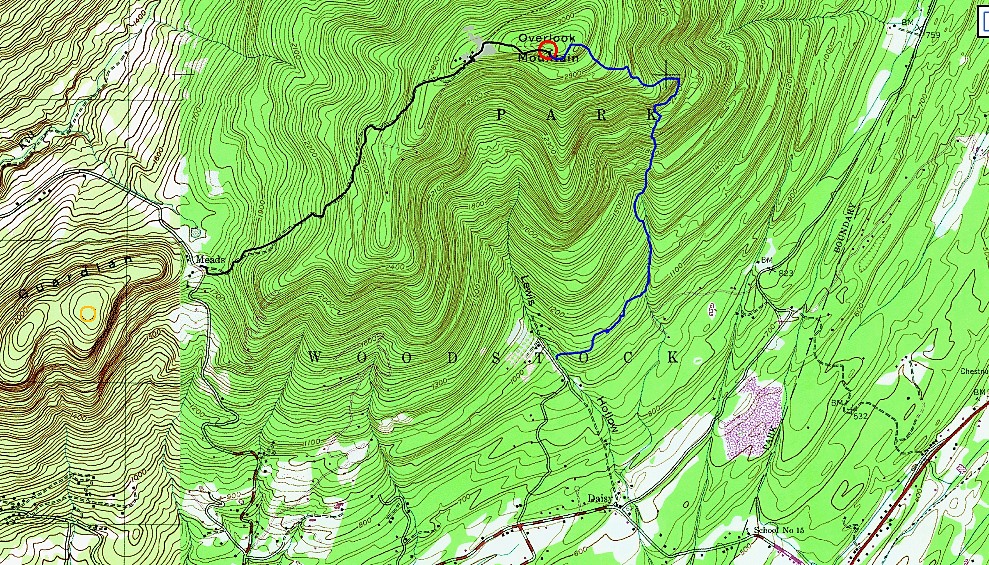
Passed by at least two dozen people heading up the mountain on the trail as this proved to be a tale of two hikes. 6 miles total for the day with over 2400 feet of ascent. Our route is shown below with the blue being bushwhack and black being the trailed portion.