Bushwhacking can provide a unique perspective on a mountain already climbed, showcasing a side of the peak few others get to see. 3573 foot Indian Head Mountain is a popular Catskill High Peak with a trail(the Devils Path) that climbs up and over the summit, which both myself and my buddy Jim had both previously done. Today, with an iffy forecast, we got a late start and decided to hike in from the Platte Clove Preserve off of Platte Clove Road. We'd start on the trail to its junction with the Devils Path, then immediately bushwhack up to the top of the mountain, and finally follow the trail from Jimmy Dolan Notch back out to a spotted car at Prediger Road. Elevation along Platte Clove Rd from the start of the hike was about 1850 feet.
To start the hike, we crossed a beautiful bridge over the fast flowing Platte Kill.
It had literally just stopped pouring rain as we began the hike. Here's a look upstream at the Platte Kill from the bridge crossing.
We followed the marked trail through the dark, damp woods up to its junction with the Devils Path. After a quick turn onto the Devils Path, we left the trail and began the bushwhack heading southwest. All the recent rain made for very wet woods and lively little streams and cascades formed where drainages ran down.
Spring is a bit slower arriving in the mountains, but we did manage to spot a trillium.
The slopes on the north side of Indian Head's "chin" were manageable, but the pesky black flies made it almost unbearable.
Found this interesting moss covered rock overhang at the top of a typical Catskill stair step.
Jim ascends another in a series of stair steps up the slopes of the mountain.
As we arrived at the top of the "chin", we found a large, flat and wet meadow area.
In some of the deep, sheltered nooks on the north facing slopes, we actually spotted some spotty ice and snow.
The climb up from the "chin" to the "head", was marked with some fun scrambling up steep, muddy slopes.
A small break in the trees provided a glimpse north towards the Blackhead Range.
As we continued up the steep slopes towards the summit, we stumbled across a very nice, but small rock slide. This spot is only about .2 of a mile northeast of the summit and went down only about 50 yards or so.
From the rock slide, we enjoyed impressive views towards Platte Clove mired in ground-fog, with Huckleberry Point rising above.
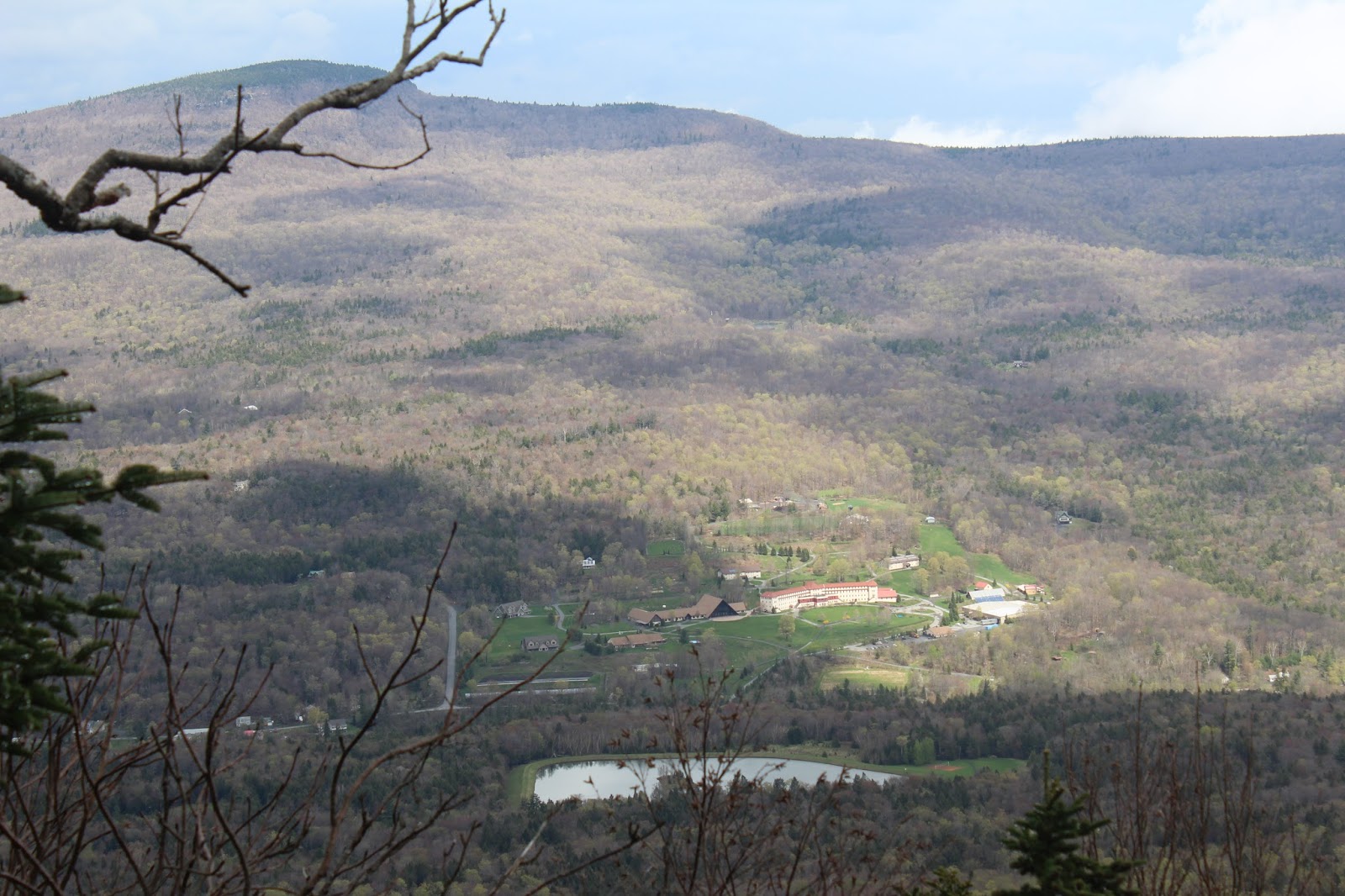
A nice view towards Kaaterskill High Point and the Bruderhof's Platte Clove Community buildings.
After exploring the slide area a little bit, we ascended the last couple hundred feet up towards the summit.
As we finally hit the summit area of Indian Head Mountain, the dark, gloomy conifers began to close in.
Once atop the summit ridge, we met back up with the Devils Path, taking us and over the summit. On the descent down towards Jimmy Dolan Notch, we stopped for a moment to enjoy the great view of Twin Mountain's north summit bump.
Arriving at the impressive, rock strewn Jimmy Dolan Notch area.
The view from Jimmy Dolan Notch is quite magnificent. The first bump in the foreground is South Twin Mountain and its long southern ridge.
Mount Guardian can easily be seen from the Notch, with the Ashokan Reservoir in the distance.
This is a very fun spot to wander around, exploring the rocky Notch and its views. Here, Jim poses for a nice shot from the Notch.
The trail off Jimmy Dolan Notch was extremely wet and actually looked more like a stream than a trail. Near the bottom of the trail we did come to a stream crossing. Our boots wer pretty much soaked at this point anyway, but we did manage to get across mostly dry.
Arrived back at the spotted car on Prediger Road under partially clearing skies. Round trip distance was about 6 miles with 1700 feet elevation gain.
Stopped briefly on the way home to take a look at the beautiful stone All Souls Church in Tannersville.


No comments:
Post a Comment