Headed up north with a couple of my longtime buddies Sunday morning to knock out the Upper Great Range in the Adirondack High Peaks, which would also bring me three peaks closer to being a 46er. We were going to approach the peaks from the Garden, but lucked out through someone else's last minute cancellation and got a spot at the St. Hubert's AMR trailhead through the parking permit system. We arrived at the crack of dawn with temps hovering near 50 degrees and set out on Lake Road through AMR property, before crossing over the Ausable River and heading up the Wedge Brook Trail.
The Wedge Brook Trail eventually leaves AMR property and hits state land as it climbs west up into Wolf Jaws Notch, with glimpses of the walls of Lower Wolfjaw's cliffs rising impressively above.
The trail arrives in the Notch at about 3500 feet, leaving a steep, but manageable 1/3 of a mile scramble up over 600 feet north to Lower Wolfjaw's summit on the W.A. White Trail. With a light breeze and temps in the upper 40's, it was definitely a reminder that summer is long gone up here. After a steep ascent, we arrived at the 4173 foot summit and found nice views west with clouds hanging just over the nearby mountaintops.
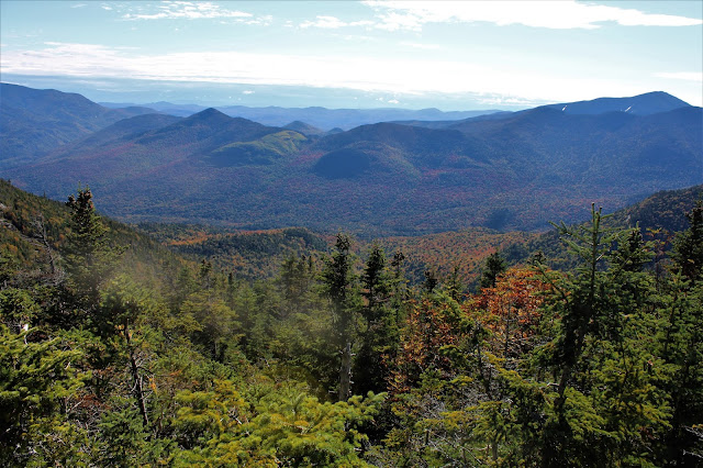
Summit views to the SW, with a thick overcast.
After a couple of minutes, we turned back, descending steeply back down towards Wolfjaw Notch, with good views south towards a false summit of Upper Wolfjaw directly in front of us.
From the Notch, we began our steep climb up towards Upper Wolfjaw, with clearing skies above. In one particular spot on the climb, I caught this nice, framed view back towards Lower Wolfjaw, where we had just been.
Up and over the false summit, we soon hit the next saddle, which was loaded with dead trees and quite muddy. We now could see the summit ridge just above us to the south.
After a few minutes of climbing we hit the spur trail, which leaves the main trail and heads 20 yards away to the stellar summit of 4203 foot Upper Wolfjaw. The views from here were much better than we had anticipated. stretching from the NW to the south. The north facing view, takes in Lower Wolfjaw and the false bump on Upper Wolfjaw, both of which we had just climbed. Just beyond, to the north, sit Giant and Rocky Peak Ridge.
The incredible view east, with Round, Noonmark, Bear Den and Dial in front and Dix rising above just beyond.
The skies had cleared and the winds dropped off, so we enjoyed lunch and the views from atop the summit. The best part of all was that we had the peak to ourselves!
From Upper Wolfjaw, we began our route over to Armstrong, dropping down to about 3900 feet before a stiff climb up. There were several very steep parts of this trail, with ladders included.
Along the way there are several good viewpoints on the climb up Armstrong, mostly to the west and north towards Tabletop, Phelps and Big Slide.
West views from the open summit rock across the Johns Brook valley. Fall colors were coming along down low in the hardwoods, albeit slowly.
The view south along the great Range is simply outstanding! Gothics looks close enough to touch, with Saddleback just beyond.
Simply stunning! A stiff, cold breeze kept us from lingering too long, but man, the views were awesome!
From the summit, we continued over to the saddle between Armstrong and Gothics before beginning our descent. We enjoyed amazing views of Gotchics and Pyramid Peak on the way down from several open ledges. Absolutely breathtaking.
There are many, many good views along this trail, where a dangerous, vertical drop off can be found just a mere foot or two off the trail. This east facing view takes in the Colvin Range, Dial and Nippletop just beyond and Dix Mountain poking out in the distance.
On our descent, we passed by this cool natural feature..a HUGE balancing boulder, which would make a nice emergency shelter.
The falls drop over 60 feet and are so picturesque that they look like a painting.
From the falls we headed east towards the Lake Road, crossing over the Ausable River, pausing to take in this nice view to the south. Some of the best fall color we saw all day was along the stretch bordering the Ausable.
A long, seemingly endless road walk brought us back to our car, feeling fulfilled. Hiked about 13.5 miles RT, with 4500 feet of ascent for the day. The AMR Permit System seems to be a success. We only saw a few people out all day, and most of them were on Lake Road. For such a new system, AMR seems to have a pretty good handle on things. We were pleasantly surprised! A great day in the woods. (29/46)


Wow, what an epic day! High peaks, streams and waterfalls...I'm glad the skies cleared up for you. I love the close-up view of Gothics, that is one good-looking mountain!
ReplyDeleteThanks Ned, it sure was an epic day! I usually don't prefer the High Peaks because they are too popular, but I must say that they sure are beautiful mountains. Add in great weather and no crowds and you got a great day!
Delete