Took advantage of a rare free day to do some exploring in the southern Adirondacks on a warm, late August day. Today my explorations would be to a rarely visited NE ridge on popular Crane Mountain. The Open Space Institute has protected the land north of Crane Mountain, which allows access to state land on not only Crane, but Huckleberry Mountain as well(which I had visited a couple years ago). I parked at the gated access road off of South Johnsburg Road(Elevation 1205 feet) and headed south, making good time on the old logging road.

After about 1.2 miles, I came to a crossing over Crystal Brook, which was an easy rock hop across.


At first I headed south, before turning more SE over towards a series of steep, rocky cliffs.

From these rocky cliffs, I was able to find several very good view points to the north and east. This is the view east towards the large wetland at the foot of Number Twenty Six Mountain, with Partridge Mountain just beyond.


Circling around the east face of the ridge, I found more open view points stretching far and wide to the SE.


After a steep climb through the thick spruce, I arrived at a large area of open rock just below the "summit".


From the open rock atop this ridge, at nearly 2650 feet, I found even more stellar views. Here is the view east.


From the high ridge, I bushwhacked back down to the lower ridge once again(which sits below 2500 feet). Near the top there are several large patches of open, moss covered slopes.

From the top of the lower ridge, I headed northwest on an obscure foot path for a short distance before bushwhacking north/ northeast back down to the logging road near Crystal Brook. Once on the old road, it was easy walk out to the car. Covered a touch over 6 miles RT, with 1600 feet of ascent total.
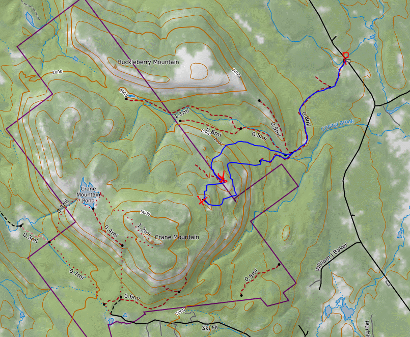
Map below. Red P=Parking off South Johnsburg Road Red X's=high point on each small ridge I hit Blue=Route taken
Loved seeing that photo of the rocky ridgeline of Huckleberry; I traversed that a few times. I hope you can get outdoors more now, especially since hiking weather is returning!
ReplyDeleteHi Ned! I would love to be getting out more but doesn't seem likely in the short term...my wife is 5 months pregnant with our second child so life is only getting crazier. Going to try my best to get out a bit more in the fall still!
Delete