There are three stream crossings on the way up the mountain.
Odd looking ice formations on the ground.
The trail is 5.0 miles RT and mostly level with only a slight climb for the first mile or so. The last half of the trail begins to climb steadily and becomes very steep for the last section. But it is well worth all the effort for the views at the summit.
The Sagamore Hotel on the eastern shore.
The Tongue Mountain Range to the north.
A close up of the Tongue Mountain Range.
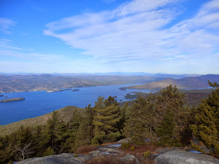
Lake George views.
Dome Island and the eastern shore of Lake George.
The summit of Buck Mountain is mostly open and rocky with outstanding views.
There are fantastic views to the east from a shoulder of the mountain.
Eastern views.
The walk back to the car through the mixed forest.
Explored a bit of the southern Adirondacks after my hike, including Brant Lake.
One of the points on Brant Lake.
Brant Lake is a very residential area with very little public access. Views from the northern shore.
Looking west across Brant Lake.
The Hudson River is very quiet in this section above Hadley.
The sun shining on the Hudson River.
The still waters of the Hudson River at Schofield Flats above Hadley.
The Hudson River in this area is much, much different than areas further south.
A public access area with camping and picnic on the north shore of Stewart Pond
Stewart Bridge Reservoir below Conkglingville Dam.
Views west towards the dam from Stewart Bridge Reservoir.
The Great Sacandaga Lake views from the pull off by Conkglingville Dam.
Great Sacandaga Lake.
Fabulous views west of the Great Sacandaga Lake, a 29 mile man made reservoir, the largest man made lake in the state.


No comments:
Post a Comment