Headed east into the Berkshires today to do some exploring in the 5267 acre Chalet Wildlife Management Area, which consists of land in the towns of Dalton, Windsor, and Cheshire. The only marked trail in the Chalet WMA, is the Appalachian Trail, which can be found in the west part of the area, running N-S along the ridge of North Mountain. My goal today was to explore a vast area further east near the Windsor/ Cheshire town line, where no marked trails exist. While checking out a slide on the east side of the ridge near Cheshire Cobbles back in August, I spotted an open area of rocky ledges across the valley that I wanted to check out. Today proved to be that day, with a forecast for clear skies but cold and windy weather. I stopped on my drive in on Windsor Road to check out the view south towards the area where I had spotted the ledges(although not visible in this photo)
I parked in a small, designated parking area for the WMA on the south side of Windsor Road, elevation 1345 feet. From the parking lot, I picked up a good foot path heading south across open meadows, with the higher terrain I was heading towards, looming just above.
Once I hit the woods, the foot path became a good woods road ascending through a dark, hemlock forest.
Although no marked trails are found in this section of the WMA, there are a myriad of woods roads criss-crossing the forest. I tried my best to stick to the ones heading the direction I wanted, while also not losing elevation.
A small oxbow in a pretty stream that drains the slopes of the unnamed ridge I was on.
As I continued south on a woods road, I could see a large, unexpected clearing coming up on my left through the trees. As I got closer, I realized that this was a pretty decent sized beaver pond, completely snowed over at 1950 feet. I even spotted a small stove just a few yards away from the beaver pond, where someone set up a small campsite.
While I was able to stick to woods roads much of the time, I did try to save some time by bushwhacking down through a deep gorge where South Brook flows and was astonished by what I found. A spectacular 40 foot waterfall from a tributary comes tumbling down the steep slopes to the east into South Brook, making for quite the dramatic surprise.
From the falls, it was a true bushwhack west through mostly open woods. The only real issue was mountain laurel, just around the area where the ledges were. I had to drop down to about 1525 feet to find the open rock, where the views were superb. The ridge that makes up Cheshire Cobbles in on the left(with the slide I was on in August easily visible). Front and center is the Greylcok Range with the valley of Cheshire and Adams below.
Same view, from a bit further up on the open rock. Wow, what a spot!!
There are actually two separate open areas of rock right next to each other. Climbing up the slightly higher, slightly east rock ledges, I was able to find this framed view of Greylock.
From the eastern ledges looking west, over at the long ridge of North Mountain, just south of Cheshire Cobbles.
On my return hike, I chose to bushwhack more instead of sticking to the woods roads. This cut off some time but added some more up and downs, crossing several small, icy streams.
The cold north wind kept me moving at a brisk pace, and soon enough I was back on my original woods road. From there it was an easy rock hop across McDonald Brook just prior to hitting the open field and my warm car.
Hiked about 6.5 miles total, with 2050 feet of ascent. It was a lot tougher of a hike than I initially thought it would be because of all of the small ups and downs, but a gorgeous untapped hiking area with much to see.
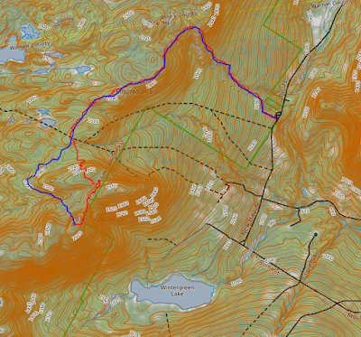
Today's route below. Red=Route in Black=Return Route Blue X=Ledges


