To the northeast of Brant Lake stand a spectacular little group of small mountains and peaks that have much to offer the adventurous hiker. Very few marked trails can be found on these peaks and the few that are here tend to lead to ponds instead of mountain tops. Some of these trails do however provide access to the peaks in the far SE corner of the Pharoah Lake Wilderness. Today's goal was to hike from the Springhill Ponds trail up to Ellis Mountain's ridge, before then leaving the trail and bushwhacking south to 2204 foot Barton Mountain. I was the only car there when arrived at the trailhead off of New Hague Road, and was the first to sign in the trail register since last weekend. Elevation to start the hike was 1160 feet, on a cold 20 degree morning.
Although a very light snow was falling, the sun did attempt to make an appearance. This was all the sun that I would see for the day, however.
The trail gradually gains over 700 feet in just over a mile, before turning south and following the ridge of Ellis Mountain. Once over 2000 feet, a good solid inch of snow coated everything white, with just enough conifers mixed in to make it very pretty. From a high spot on the ridge, I caught a fleeting glimpse of Barton's north ridge poking out through the trees.
After a bit over 2.3 miles, the trail begins to lose elevation, and heads west towards the ponds. This marked my jumping off spot, as I began my bushwhack heading south. The woods were mostly open but cold and wintry.
There was really only one thick area of spruce to contend with but the closer I got to Barton, the tougher the terrain got.
A low spot in a rugged, boulder laden ravine.
Surprisingly enough, I picked up a pretty good herd path about 1/4 of a mile before the summit, so I stayed on that for a bit before regretfully leaving it too soon and hitting thick spruce and lots of blowdown. Luckily this didn't last long and before I knew it I found the open, east facing ledges I had been seeking.
The open ledges are quite nice, and even with light flurries falling, the view was good. Wintergreen Lake can be seen to the right in the foreground, with Round Mountain just beyond that. Off in the distance, just past Round Mountain is part of Lake George. A very careful eye can even pick out a small sliver of Lake Champlain far off in the distant left.
To the NE, the view takes in Barton Mountains private north summit ridge, with Trumball Mountain just beyond. I can only imagine just how good this view would be on a clear day.
Just over 1/10 of a mile west of the view spot is the wooded 2204 foot summit, marked with a small cairn.
After hitting the summit, I decided to head more westerly off the slopes of the mountain, avoiding the thicker, rougher ups and downs up high. A nice view here from below the rugged cliffs near Barton's summit.
I leisurely took my time, heading back towards the marked trail, avoiding the steep terrain through open hardwoods. A quiet little wintry stream was my companion for several minutes as I soaked in the ambiance of the December woods.
Once back to the trail, I retraced my steps uneventfully back off the mountain. Hiked about 8 miles RT, with over 1900 feet of total ascent.
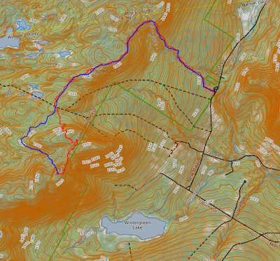
Today's rough route below. Red=Ascent Blue=Descent


Even with limited views the views are great! There's nothing like the Pharoah Lake wilderness...Last time I was there I hiked to Gull Pond; what a place!
ReplyDeleteYeah, the Pharoah wilderness is an awesome area. Definitely planning on some more adventures in that neck of the woods soon
Delete