Headed into the northern Berkshires to hike 2195 foot Flat Rock Hill, an obscure peak in the town of Florida, high above Route 2(The Mohawk Trail) on an unusually warm spring day. The temperature was rapidly rising through the mid 70's in the early morning as I arrived at my starting point along South County Road. I parked near the beginning of South County Road(Elevation 1800 feet), which is an unmaintained secondary road, and walked just over a half mile along the rough road to a spot where a snowmobile trail heads north into the woods.
The snowmobile trail comes close to but not up to the actual summit, which was a short bushwhack away. The true summit is wooded and offers no views.
From the true summit, it was a short bushwhack back to the snowmobile trail and then about 3/10 of a mile further north I came to a power line crossing at an unnamed 2230 foot high spot on the ridge. This high spot could actually be considered a south sub summit of nearby Whitcomb Hill and offers up great views. To the west/ southwest the views take in the nearby Hoosac Range and all the way to Mount Greylock towering in the distance.
A zoom view towards Greylock with the power lines cutting through the hills of Savoy.
From the opposite side of the power lines, a short walk away, is a great view northeast into the rolling hills of nearby Monroe and Rowe. Pine Cobble is to the right of the power line cut with Upper Reservoir Bear Swamp being the body of water visible just right of center.
Just north, a short distance beyond the power line views, are remnants from the Hoosac Tunnel, which was cut through these hills back in the late 19th century. A pretty neat find.
Turned around at the Hoosac Tunnel remnants and retraced my steps back off the mountain. A little over 4 miles Round Trip for the day and over 600 feet of combined ascent. Didn't see another soul on this very warm, summer like day.
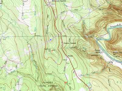
Map below. Red P=Parked Car Red X=Flat Rock Hill summit Blue X=Power Line Views
.JPG)
.JPG)
.JPG)
.JPG)
.JPG)
.JPG)
.JPG)

No comments:
Post a Comment