Search This Blog

Monday, November 11, 2019

Warner Mountain-aka "Ski Butternut"(Berkshires)

Headed over to the southern Berkshires this morning to check out 1764 foot Warner Mountain and Ski Butternut, the ski resort which resides on the north slopes of the peak.  The ski area can be found on Route 23 about 1.5 miles SE of the 7/ 23 split just east of the village of Great Barrington.
I had previously contacted the ski area to get permission to hike the mountain and they didn't seem to have any problem with it.  There were only a couple of workers there when I arrived on an overcast 45 degree day, and they waved as I made my way towards the ski lifts.
Started at an elevation of about 840 feet as I made my way over to one of the main ski runs, called "Main Street".
I immediately began climbing, and within moments already had some views behind me to the north.
I stuck mostly the sides of the slopes, following the tread of the service vehicles.
As I pushed up the slopes, I could hear rushing water in the woods, so I decided to poke my head in and check it out.  The pretty stream tumbling down through the hemlock ravine offered up a much more natural scene than the open ski slopes.
Once back on the ski run, I crossed over a maintenance road high up on the mountain, switching over to the steeper "Whip" run.
Thank god for the open ski slopes!  One glance off trail provided a glimpse of thick mountain laurel, which cover many of these southern Berkshire peaks.
The "Whip" run heads steeply up towards the summit ridge, soon meeting up with the "Pied Piper", the final push up to the summit.
Arriving at the 1764 foot summit of Warner Mountain, where I found some small patches of snow scattered on the ground.  A local radio tower can be seen as well, just off the summit through the trees.
The summit view down the black diamond "Lucifer's Leap" trail to the north.
After exploring the summit area, I headed back west, down the "Pied Piper" run, a mellow descent.
Up high in a notch at about 1500 feet, I left the ski slopes again checking out some of the woods of East Mountain State Forest.  I found mostly open woods, with scattered mountain laurel and a pretty vernal pond, which looks like it has just started freezing over.
Back on the ski slopes again, this time on the "Freewheeler" trail, which is the furthest west of all the runs, I found some of the best views of all.  North views up towards Monument Mountain, with Three Mile Hill to the right in the foreground.
To the immediate left is East Rock(the northern extension of neighboring East Mountain), with Tom Ball Mountain and the Taconics in the distance left.  In the center is the valley of the Housatonic and Flag Rock/ Monument Mountain rising up to the right.
One more view of Monument Mountain over Three Mile Hill, with a corner of Beartown Mountain to the far right.
Once back down at the base of the mountain, I headed back over towards my car, passing by the several of the ski slopes on my way,
Very soon these ski slopes will be all hustle and bustle, filled with skiers enjoying the winter snows.  Today all was quiet, as I hiked about 3 miles altogether with 1100 feet of ascent.
Today's route below.  Red=Ascent    Blue=Descent

Saturday, November 9, 2019

Thacher Park South(Albany County-Helderbergs)

Did a quick post work hike this afternoon in the southern section of Thacher Park off of Beaver Dam Road.  The sun was shining brightly when I arrived, but there was a chill in the air with temps only in the mid 30's.  Elevation in this part of the park is between 1400 feet along Beaver Dam Road and 1200 feet near Hop Field.
Although the valleys are snow free, the hills have a light coating of white, especially in shaded areas or north facing slopes.
I explored many of the quieter trails in the park that see far less foot traffic than those around the escarpment area.  It is a beautiful area, and I actually really enjoyed the sense of solitude.
The highlight of my walk was a small stream near the Hop Field picnic area. Just off the orange trail is an impressive 15 foot high cascade with multiple ledges located in a small ravine.  The tiny stream drains from a swampy area and tumbles down the escarpment about 1/4 of mile further downstream from the falls.
Hiked a nice and brisk 2.5 miles RT on various trails and didn't see another soul the entire time.  Attached below is a portion of the southern section of Thacher Park that I hiked today, courtesy of NYS.

Wednesday, November 6, 2019

Widow White Peak(Berkshires)

In an attempt to beat the early sunset after work and do some local exploring, I decided to head east to Hancock in the Berkshires to hike 2430 foot Widow White Peak.  The Berkshire Natural Resources Council owns and manages this 270 acre property which covers the east slopes of Potter Mountain, which is much more well known for Jiminy Peak, the ski area which resides on the ridge's west slopes.
I parked in the rough, grassy parking area on the west side of Silver Street, less than a half mile from Bailey Road in the town of Lanesborough.  From there, at an elevation of 1475 feet, I dropped down to check out pretty Secrum Brook.  Secrum Brook is one of Pontoosuc Lake's main sources and is also known locally as Disappearing Brook because it "disappears" into underground channels several times on its way to the lake.
After briefly enjoying the babbling brook, I headed back up the lower slopes of the mountain, with the quickly setting sun just above the summit ridgeline.
There are numerous woods roads that criss-cross these slopes, so I followed them as long as they went in the general direction of the summit.  Within just a few minutes of climbing, lengthening shadows began creeping in, even at only 3pm. 
Like many of the wooded peaks in the northeast, stone walls indicate that these slopes were once cleared and farmed.
With the early sunset, I decided to leave the meandering woods roads and bushwhack straight up towards the top. The terrain is steadily steep, but two areas in particular are a bit tougher, especially the slopes directly east of the summit.
  Once atop the summit ridge, the sun was shining brightly, in very pleasant, open hardwoods.
Once hitting the 2430 foot wooded high point of the ridge, I began to head back down, staying a little further north than on my ascent.  I enjoyed filtered views to the east through the bare trees.
On my descent I picked up yet another woods road, this one with blue blazes, as it passes through a stark naked woodland.
From a sliver of an opening at about 1800 feet, I found the best view I had all day.  A small window through the tree tops gives a glimpse east towards the Lanesborough countryside.
There is a bit of history to be found on these wooded slopes as well,  if you have a keen eye.  Although very hard to read now, this weathered engraving was done by Captain John Brown, a scorn lover back in the late 1870's.  His failed attempt to marry Susan Baker, the landowner at the time, lead him to inscribe the words "May God Bless Susan and all her baren land and when she get to heaven I hope she'l find a man"
As I arrived back at the parking lot, the early sunset had nearly caught me.  Darkening woods and short days meant I got out just in time.
Hiked about 3 miles RT with about 1100 feet of ascent.
A map of the Widow White property, from BNRC's website.

Monday, November 4, 2019

Thomas Cole Mountain from Colgate Lake(Colgate Lake Wild Forest/ Windham-Blackhead Range Wild Forest-Catskills)

The Blackhead Mountain Range stands stalwart at the far northeast edge of the Catskills and are visible from as far away as the southern Adirondacks.  They make for a fun trail hike that many folks get out and enjoy all year round, but my goal for today was to bushwhack the southern ridge of 3940 foot Thomas Cole Mountain from Colgate Road(Greene County Route 78).  I parked at the first parking area on the left(north) side of the road, starting from an elevation of about 2050 feet.  A myriad of unmarked foot paths march north from the parking area crossing an open meadow and leading to several informal campsites and fire pits. I continued north beyond these fire pits, passing through a nice, shaded conifer forest. 
I headed north-northwest towards the edge of state land, where Halsey Brook flows down out of the mountains. 
The woods quickly transition back to deciduous trees, with a sea of fallen leaves on the ground. I stayed on the east side of Halsey Brook, continuing north near the state land boundary, where I actually saw a red blazed trail on the private property side. 
Elevation gain is slow at first, but near the south end of the ridge at about 2900 feet it becomes quite steep.  With the leaves off the trees, Black Dome's ridge can clearly be made out to the northeast.
The ridge thins out as it gains elevation, passing through several large plateau like areas on the way.  At about 3400 feet I came to this screened view of the valley to the south, at the headwaters of a drainage. 
From between 3500 feet and 3700 feet, there are a series of small clearings, each with decent(and some very good) views.  The first set of sandstone ledges is also the most impressive from below.
Poked around the clearings and view points, which face both south/ southeast and south/ southwest.  Here is a view due south towards the Devils Path peaks with Onteora Mountain just in front of them.
To the west along Thomas Cole's ridge one can easily pick out The Caudel and Camels Hump.
SW views down over the East Kill valley of Route 23C in Jewett, with the East Jewett Range rising above.
A lone spruce tree atop Camel's Hump.
Black Dome's southern ridge, with Dutcher Notch, Stoppel Point(and West Stoppel Point) just beyond.  Lake capra and Colgate Lake clearly visible as well.
Perched atop a wide open east facing ledge is this impressive view of neighboring Black Dome Mountain(with Blackhead poking out beyond).
Sprawling SE views down towards Lake Capra and Colgate Lake from my lunch spot.
Much of this section of the ridge took on the appearance of this low brush meadow.
West views from a small clearing.
Mountain Ash Berries.
At about 3700 feet, the open meadows quickly ended and transitioned back to a dark, hemlock forest.  The hemlock's do a great job of locking up the cool air, and wintry conditions were witnessed for the first time all day.
Just below the summit, one more steep push found me passing by a large area of icicles.  Yet another indication that winter is well on its way to these mountains.
Once atop the summit ridge, I hit the red blazed DEC trail, but quickly left it in search of a true high point.  I had a hard time finding one particular spot as my GPS and my eyes both disagreed.  I settled on this nondescript spot as the true 3940 foot summit.
After hitting the high point I hopped back onto the trail and followed it off Thomas Cole, heading east over to Black Dome.
Passed over the wooded summit(which I've been to a couple of times previously)and continued on down to the east view point towards Blackhead. 
I almost forgot how good these views are from these ledges.  Breathtaking views NE over the escarpment wall towards the Hudson Valley.
I continued beyond the views, dropping down the trail to Lockwood Gap, the saddle between Black Dome and Blackhead.  From there, I left the trail and bushwhacked south back down towards Colgate Lake.  The slopes were steep but no ledges or difficult spots to descend.  Down around 2800 feet, I came to the washed out slopes from one of the mountain;s drainages, with Blackhead's ridge towering above. 
Continuing south, I came to another washed out slope from the drainage.  Mother nature can be quite impressive.
Eventually picked up a good woods road, that headed south right towards Colgate Lake.  I stayed on it for a while, before finally heading more SW to the car.
Just prior to arriving back at my car, I came to a pretty tributary stream, flowing swiftly down through a beautiful hemlock forest.  Splashed some of the cool water in my face and then headed out to the car.
A fun bushwhack/ trailed hike, with over 2300 feet of ascent and 8 miles RT.
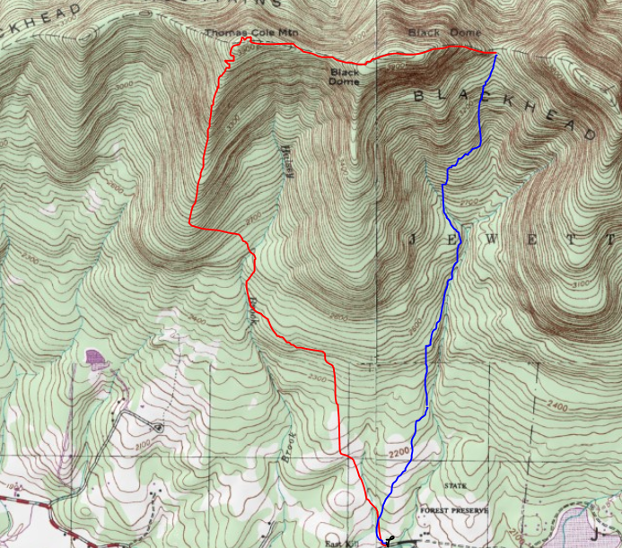
Today's route.    Red=Ascent  Blue=Descent