A small parking area is found in a large, open field. There are spots for handicapped parking, as well as a drop off area for non-motorized boats further down the road. I parked my car and walked across the road to a series of informational signs in front of a large meadow.
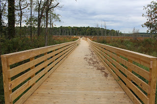
Continuing along the road on foot past the drop off area, I soon arrived at a brand new, beautifully built boardwalk through wetlands down to the Anthony Kill.
The view of the wild wetlands from the boardwalk.
There are more informational boards found along the boardwalk as well.
The boardwalk eventually leads down to the Anthony Kill and a brand new boat launch. The Anthony Kill flows a few hundred yards upstream out of Round Lake and empties 7 miles downstream in the Hudson River at Mechanicville.
I backtracked off the boardwalk and crossed the open fields to a path of sorts that runs along the lake.
The path is easy to follow but very overgrown, leading to an old hunting camp. From here it is a few yards to the shores of Round Lake.
Looking west across Round Lake.The southern shoreline of Round Lake. I spotted a couple fishing in a canoe out towards the middle of the lake.
I followed the path until it arrived at another open field, which didn't appear to lead to anything else. I retraced my steps from here back to car. There are future plans to build more trails, additional boardwalks and a non-motorized boat launch in Round Lake.
After leaving the preserve, I headed north to the nearby 100 Acre Wood Trail System, which oddly enough, compromises only 30 acres in size. This trail system is part of Luther Forest Technology Park(LFTP), an important recreational green space for the town.
The easiest way to find the trailhead is to take exit 12 off the northway, and drive east on Route 67 to Route 9 south to the first roundabout, where Stonebreak Road heads east. Drive 1.1 miles on Stonebreak Road to the trailhead sign on the right side of the road. A small parking area with room for about 8 cars and a trail map are found here.
There are about 2 miles of trails that wind trough these woods on color coded connected trails.
Walking is very easy on mostly flat trails.A small stream meanders under a footbridge along the green trail in the southern section of the woods.
A well built stairwell climbs up the steep banks from the stream.
Took all the trails in the woods and saw several people out walking their dogs on this last day of summer.


No comments:
Post a Comment