Access to the trails can be a bit tricky, but we simply parked at the elementary school , located on the east side of Route 22, then crossed the road and took the sidewalk north to the historic blue and yellow sign(seen in above photo) marked "Dover Stone Church". Turn left here and walk up the private drive(which is open to pedestrian traffic) to the end, where you will enter the preserve. A trail map is posted on a tree right before the entrance.
The first site you will see is a set of stairs leading down to a large, open field with a clearly defined path heading through a tree lined meadow.
This section of trail is very unique, and we enjoyed a slow stroll through here, but with no shade, we fried and decided to move along on a hot summer afternoon.
Once across the open fields, we passed and kiosk and then entered a stand of hardwoods, which provided welcomed shade.
Walking through this section of woods provides your first glimpse at the quietly meandering Stone Church Brook.
Coming to a nice foot bridge over the brook.
We chose to visit the Stone Church first, which was obviously the main draw and we had a lot of company along this short but beautiful section of the hike.
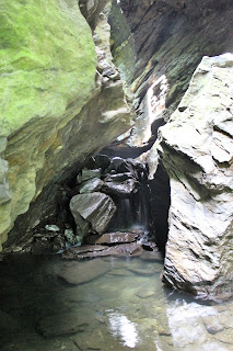
After following the brook for just over .2 of a mile the rock walls around you become increasingly steep and rugged and all of the sudden you arrive at the Stone Church. We had seen pictures on the internet, but the sheer size of the cavernous arch like entrance was very impressive in person.We carefully made our way along slippery rocks to the entrance and explored the inside of the cave for a few minutes, with the sounds of rushing water echoing all around you. A waterfall tumbles down around a corner and can easily be found by following the sounds of rushing water.
We looked all around the inside of the cave, but found that nearly all of the rocks were wet and slippery with some being unstable. This can be an incredible spot to visit, but please use caution when walking on the rocks.
Another look back at the entrance.
Cascading water along Stone Church Brook.
We enjoyed a nice, short walk back along the brook to the trail junction, where we turned right onto the newly built and marked trails. A small pond comes into view just after the turn.
We quickly began climbing up through evergreens following yellow, red and blue markers. A bit further along, the yellow and red trails leave to the left forming lower and upper loop trails. We opted to stay straight on the blue marked "Lookout Point" trail.
The Lookout Point trail is a 1.5 mile out and back trail. It is the most challenging of the three trails and also leads to the highest point in the preserve. From this high point, a rocky prominence provides superb views to the east.
A view southeast. The marked trail dead ends here, but there are many informal foot paths that wander along these cliffs, providing countless views.
A look back down towards the quiet village of Dover Plains.
Looking northeast towards the Connecticut state line.
After enjoying the views from the overlook, we finally turned around and made our way back over stone walls and down through the woods. We passed this gorgeous open meadow beneath blue skies and paused to relish the moment.
We discussed exploring the yellow and red loop trails, but the excessive heat and humidity chased us back to the car early. We really enjoyed our visit to the preserve, hiking about 2.7 miles RT. This seems to be a spot growing in popularity and can be very busy on a summer weekend. My advice to anyone seeking solitude here, would be to come midweek or during the off season.


No comments:
Post a Comment