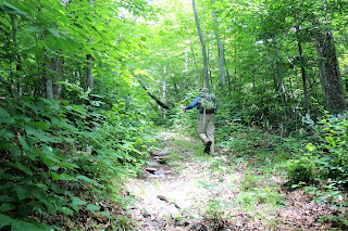
After about 1.7 miles we arrived at the nondescript flat summit of South Sherrill Mountain. With an elevation 2883 feet, we had climbed roughly 1600 feet from the car.
We paused briefly at the summit(a Catskill 200 highest), and then began our descent to the northeast into the col between South Sherrill and Sherrill. A nice breeze accompanied us along this stretch, as the woods dropped down to just under 2600 feet elevation.
We were a bit surprised to see wildflowers blooming along the way. We passed several areas of bee balm and coneflowers.
The ascent up Sherill is steady, but manageable until around 3000 feet. From there the climb began to get quite steep.
We found an old woods road and followed that up quite a ways.
While following the woods road, I happened to notice an old circa 1950's school bus, parked in a small clearing. The bus is now used as a rough shelter for hunters and campers.
Jim posing with the bus. He was extremely pleased as this had been on his radar for quite a while and had proved elusive.
Shattering Jim's bucket list.
The woods level out above 3400 feet and gradually ascend to the 3540 foot summit.
The summit canister.
Signing in at the summit canister. My 33rd Catskill High Peak.
The descent off Sherill's summit is about 500 feet in a little over half a mile. Nearing the col, the slopes get a bit steeper.
We found a neat looking break in this rock band between the two peaks. Upon closer inspection we found...The summit canister. This is my 34th Catskill High Peak!! One to go!!
We dropped off the summit area, heading generally southeast on the herd path and then began bushwhacking to North Dome's southeast ledges. A small opening in the trees provides outstanding views. St Anne's Peak is directly across Mink Hollow, with West Kill Mountain behind that and Hunter Mountain behind that.
Wildflowers growing along the steep rock face of the ledges.
The east side of North Dome is extremely steep, no matter which route you take. The further south you go the steeper it gets, with some areas being unsafe to pass. We found a safe route down, dropping about 1300 feet in about one mile. From there we crossed mostly dried up Mink Hollow Brook, pausing to cool off in the cold mountain water.
Once crossing Mink Hollow Brook, we picked up the Devils Path, staying on the trail north for just over a mile, arriving back at my car. We had a great day in the woods, bagging three summits. Total mileage was a little over 8 miles with over 3000 feet elevation gain.


No comments:
Post a Comment