I headed into Cattleshed Field, descending east through the open fields. A dated, stone building sits down near the base of Cattleshed Field, and appears to have been some kind of farm structure. The structure is showing obvious signs of despair, with a crumbling tin roof and no walls left at all on the east side.
Just a few yards past the old building, from the very bottom of the open fields, looking back towards my car, with the ridge of Prospect Hill beyond.
From the bottom of the fields, I entered the woods, quickly crossing over pretty Karner Brook with an easy rock hop. This marked the low spot in the hike at a little over 1400 feet.
Once across the stream, I headed NE through open hardwoods, finding a couple of woods roads on the way.
The west slopes of Mount Whitbeck were incredibly open and I made great time ascending until I neared the summit ridge. Once near the summit, I left the open hardwoods behind and entered into thickets of mountain laurel. Luckily, I found my way through game/ herd paths which made things a bit easier.
Once atop the summit ridge, I wandered through thicker stands of mountain laurel in search of the summit.
I poked around until finally I found what appeared to be the 1904 foot summit, with just a hint of snow in a small hardwood clearing.
I dropped off Mount Whitebeck's summit, heading south towards the col between Whitebeck and Sterling, where I stumbled across a pretty, partially frozen vernal pond.
The east slopes of Mount Sterling are quite steep, but I had a hard time getting much more than a screened view through the trees. I would've loved to have explored more in search of views, but the mountain laurel was absolutely exhausting to push through.I did my best to push my way up towards Mount Sterling's summit, but the mountain laurel guarded the summit, making any progress impossibly slow. It was very frustrating as I struggled to make my way forward, fighting for every step. I finally found what I believe was the summit in thick stand of mountain laurel.
After reaching the summit, I wasted no time leaving the mountain laurel behind, heading west back into open woods. A short distance off the summit, I found another pretty vernal pond, this one slightly smaller than the other I had seen before.
Once back in the open woods, I made a quick descent, passing over a couple more old tote roads. Down on the lower slopes of the mountain, the woods were incredibly open...such a relief after the struggle up high on the ridge.
Crossing over picturesque Karner Brook.
Looking back on the final climb up through Cattleshed Field, with the dilapidated barn and ridge I just climbed behind.
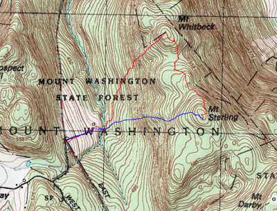
Hiked about 3.3 miles RT with 800 feet of ascent. The route below. Red=Ascent Blue=Descent


No comments:
Post a Comment