Headed up north again this afternoon to check out a pair of unnamed, obscure peaks that lay just off the beaten path west of Route 9N near the Tongue Range in the town of Bolton. Although these peaks don't rank in the upper echelon in elevation, they pack a punch in fun, steep climbing and exploring. There are no trails here either, so both of this peaks would be true bushwhacks. Parked on the shoulder of the road at the corner of Padanarum Road and Wardsboro Road, where the old bridge over Northwest Bay Brook is being replaced(Elevation 435 feet).
Began my hike heading north along beautiful Northwest Bay Brook for a few hundred yards before turning east and heading up the slopes of the first unnamed peak.
There are a couple of different levels of open rock slab to explore, with solid views to the south.
From a nearby vantage point, a view west across the road towards my next peak, less than a mile away.
The open views were actually quite low on the slopes at about 750 feet, so it was a nice and easy bushwhack up through open woods east to the summit area.
Unfortunately, the 995 foot summit is wooded with filtered views to the south through the trees.
A steep, but quick and easy descent brought me back down to the road, where I crossed the bridge over Northwest Bay Brook and headed right back up the next peak. This peak, which lies just west of the road, is a bit bigger and was a little tougher as well. Although the climb up through ferns looks unassuming enough, there are ankle swallowing boulders hidden throughout.
The other nice part about climbing higher were the nice views that I was able to find, such as this look east towards my previous peak(with part of Bloomer Mountain's west ridge in the distance).
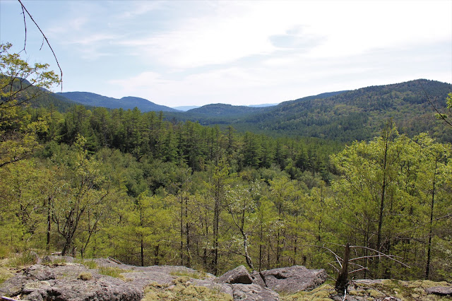
As I steadily made progress ascending, I kind of veered slightly south to gain better and better views where the slopes really dropped off. Enjoyed this nicely framed up close view of a large swath of the Tongue Range from an open ledge.
There were several good viewpoints along an open area of southeast facing ledges, but it only kept getting better the more I went up.
From an open perch, I found this spectacular view east towards the Tongue Range, with Five Mile Mountain being the high point on the ridge,
A sprawling view SE towards the entire southern part of the Tongue Range!
After enjoying the views, I continued on a short distance north to the wooded 1161 foot summit.
As mentioned before, the elevation may not be all that high but the steep descents on these small peaks can really be a fun adventure.
Following a steep descent, I arrived back down at the foot of the peak, near the bridge crossing and headed over to my car. A lot of bang for the buck in these small little hills! Just over 3 miles RT(all bushwhack) with 1300 feet of combined ascent.
Map below features the two nameless peaks, marked with red X's. The blue P, is where I parked.


No comments:
Post a Comment