Headed up into the Green Mountain National Forest in Vermont to do a little part trail/ part bushwhack exploring on a hot, summer like day. My goal was to hike via trail to Lye Brook Falls, which I had previously visited, and then bushwhack up to a couple of large jumbled rock slide areas higher up the peak. Got an early start in an attempt to beat the heat and arrived at the trailhead at the end of Glen Road just after sunrise.(Elevation 780 feet)
After about 1.8 miles, the trail to the Falls splits right and descends a bit over 4/10 of a mile down to Lye Brook Falls. This is truly a majestic site and it was a pleasure to have the 125 foot falls to myself!
After enjoying the falls, I backtracked about 1/10 of a mile to the site of a huge destructive slide that dates back to Tropical Storm Irene in 2011.
After surveying the slide area, I decided to give it a go, climbing steeply up and being careful to keep good footing along the way. The neighboring unnamed ridge line to the west blocks any potential views however. After reaching a point where the slopes became too steep and slick, I dove into the woods, continuing my ascent.
Climbing east, my route soon came to the Lye Brook Trail at about 1800 feet, which I crossed over and then continued to bushwhack NE towards the rock slides I was looking for.
The woods were mostly open and easy to navigate and soon enough I arrived at the base of the first area of loose boulders, which was actually a bit broader than I thought it would be.
Pinksters were abundant on this peak and are one of the prettier spring wildflowers in the mountains(IMO).
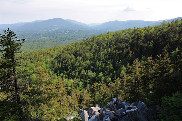
Although sitting at 2100 feet, the views from the first rock slide area of jumbled boulders are decent but limited. Here's a peek south towards the ridge called "The Burning" on topographic maps.
From the higher area of rock slides, I dropped NW down to below 1800 feet and a killer view spot. From an area of very steep, white rocks, the terrain drops off significantly.
To the NW, reaching across Manchester, the far north end of Mount Equinox ends at Mother Myrick on the left and Mount Aeolus on the right.
More azaleas(pinksters) near the view point.
A short but steep bushwhack brought me down to the marked trail, which I followed back to the car, narrowly beating the incoming crowds. Only passed a couple of small groups on the trail, but two more carloads were arriving as I packed up my car to leave.
Hiked about 5.5 miles RT, with 1600 feet of total ascent.
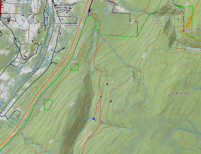
Map Below. Blue P=Parking Blue X=Falls Black X's=Ledges


.JPG)


.JPG)
.JPG)


.JPG)


.JPG)

.JPG)
.JPG)
.JPG)
.JPG)

.JPG)

.JPG)
.JPG)


.JPG)

.JPG)

.JPG)

.JPG)
.JPG)


.JPG)
.JPG)
.JPG)
