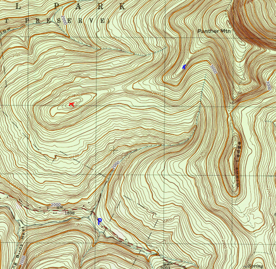
It has been extremely difficult finding free time with a newborn baby, but I was finally able to squeeze in a day of hiking down in the Catskills. Headed out on an unseasonably mild winter day and wanted to explore the ridge west of Panther Mountain's summit. This entire area I'd be covering today has no trails and in addition would involve two water crossings of Giant Ledge Stream which drains the slopes above. I managed(barely) to fit my car off on the shoulder of Oliveria Road(CR 47)in a small area where state land comes down to meet the road-about 9/10 of a mile west of Giant Ledge parking area(Elevation 1925 feet).
Once geared up, I headed NE into the woods, quickly picking up a decent herd path that parallels Giant Ledge Stream with almost no snow on the ground.
.JPG)
.JPG)

.JPG)
.JPG)
.JPG)

The terrain east of the saddle is much more rugged and steeper, which of course made for a fun climb.
.JPG)
Up and over 3100 feet, the woods open up quite nicely, with an extremely deep drop off to the SE providing up close views of Panther Mountain's main ridge line.
.JPG)
.JPG)
.JPG)
After enjoying the views, I headed back down around the steepest cliff bands I had just climbed up and began my descent south into the deep cut of Giant Ledge Stream. This proved to be the toughest aspect of the entire hike, with snow covered terrain dropping nearly vertically into the stream on both sides. Luckily I managed a safe water crossing and even took a moment to capture the beauty of this remote area of the stream.
.JPG)
The tough work wasn't over once across the brook, as I still had a steep climb and side hill out of the deep gorge.
.JPG)
Finally back up on higher ground, it was an easy walk south back to my waiting car. Covered about 4.5 miles round trip with over 1500 feet of ascent. Of course being so far off trail, I didn't see another soul all day-although I saw plenty of animal activity in the snow.
Map below. Blue P=Parking Red X=West Ridge "Summit" Blue X=Vista
Congratulations on being a new dad. Really appreciate your 247 walking man stuff. Great work. Thanks.
ReplyDeleteThanks man, I appreciate that!
Delete