Search This Blog

Friday, August 14, 2020

Cheshire Cobbles/ Slide-Appalachian Trail(Berkshires)

Decided to do a quick little hike to Cheshire Cobbles in the Berkshires after work this afternoon...with a little twist added in.  That twist was to finally find a large rock slide that sits less than half a mile off trail to the SE of the Cobbles.  First things first, I parked in the unmarked parking area off of Notch Road which provides access to the Chalet WMA.  Elevation here is roughly 1100 feet, where an unmarked but obvious foot path heads south into a shaded hemlock forest.

There are a series of unmarked trails that criss-cross these woods as it climbs, but the main trail is pretty obvious and eventually meets up with the Appalachian Trail.  At this point, you have gained a few hundred feet and the woods have transitioned to hardwoods.
A final steep push up, brings you to the spot known as Cheshire Cobbles.  It is an large area of open rocks that offers up expansive west facing views.  The Greylock Range looms impressively above the village of Cheshire to the NW from here.
To the SW, the view encompasses much of Cheshire Lake.
A short distant beyond the viewpoint along the AT, at the actual top of "The Cobbles", I found this Witness Post Survey Marker.  Has certainly seen better days, however.
Continued on a short ways beyond the high spot before leaving the trail, beginning a bushwhack east through the woods.  The woods were mostly open, with just some annoying low growth and witch hobble to slow me down.  After roughly 4/10 of a mile and a little bit of up and down I found the elusive slide I had been searching for.  The views east are quite nice, but I clearly wasn't the first to be here.  Lawn chairs and a fire pit told me that locals are probably well aware of it.  The Hoosac Range rises off in the distance to the NE.
The sheltered valley of Notch Road sits below to the east with the nearby hills of the Chalet WMA just above.
To the SE, across the valley I spotted more open rock on the next ridge over.  If I had more time I would've loved to explore that area, but for now will have to chalk it up to a future trip.
After enjoying the views from the rock slide, I headed back to the trail and easily descended back the way I had come.  Just prior to arriving at the car, I dropped down into the deep gorge cut out by McDonald Brook, where a pretty little area of cascades tumbles into a small pool.  This made the perfect spot to rinse up and get some of the sweat off. 
 Hiked about 3.3 miles RT with just under 1000 feet of total ascent.  

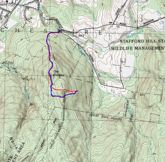
Today's Route below.  Red=Ascent(in)   Blue=Descent(return)


Tuesday, August 11, 2020

Appalachian Trail-October Mountain State Forest(Berkshires)

Sometimes it's the nice and simple hikes that really hit the spot.  You know, the ones where there isn't some big splash at the end...no oooh's and aaah's.  Today's hike along the Appalachian Trail up on the Berkshire Plateau(elevation between 1930 and 2000 feet) in the October Mountain State Forest really fit that bill.  I parked at the trail crossing on Washington Mountain Road, where there is room for several cars. On this hot summer morning, there was only one other car when I arrived.

I headed south following the familiar white blazes, soon passing through the remains of a non-native Norway Spruce Plantation.  This was planted back in 1938 by the Civilian Conservation Corps on abandoned farmland and is now undergoing man-made changes for the better.

 
The trail continues SE, passing through lovely fern glades and occasional wet areas accompanied by puncheon.

 
A short distance into the hike, I could see a large, sprawling wetland through the trees on my left.  I took an informal path down to the water's edge, where I spotted a large beaver dam sitting just a few feet away.
 
 
Back uphill away from the water, the trail circles around the wetland through a gorgeous mixed forest.

 
Just prior to arriving at gravel West Branch Road, the trail comes to the first of a couple nice clearings, offering up fantastic photo ops of the large wetland.  This place has the feeling of being more remote than it really is, and seems like the perfect spot to see a Moose.
 
 
Once across West Branch Road, the trail heads uphill into a mostly hardwood forest.  Just moments later, a sign addressing Lean To abuse issues is posted on a tree.  Such a shame.
 
 
About 7/10 of a mile beyond the road, I arrived at the shelter.  It's a small but tidy shelter with informal tent sites, a privy and water source all around.  Met this man(pictured below) at the shelter who had a fascinating story.   He had hiked over 1800 miles of the A.T. back in 1977, but then got injured and had to stop.  43 years later, now retired, he is continuing his quest to finish the rest of the trail.  What a great guy...and a great attitude!

 
The Lean To shelter itself, is quite nice, with 4 bunk beds inside.   I stayed and chatted for a bit, before turning back.

 
 Retraced my steps back north from the Lean To, enjoying the solitude of the woods.   A light breeze did its best to cool me off on this otherwise steamy summer day.
 

Hiked 4.4 miles RT, with only a couple hundred feet of ascent.  A pleasant little area, that flies far below the radar.
 

Monday, August 10, 2020

Mount Colvin and Blake Peak(High Peaks Wilderness-Adirondacks)

Decided to head north up to the Adirondacks again today to knock off two more High Peaks with my buddies Joel and Mark.  Today's goal was to hit 4057 foot Mount Colvin and 3960 foot Blake Peak from Lake Road at the Ausable Club in Saint Hubert's.  The forecast was for high temps and humidity and a chance for storms, so we brought plenty of fluids and hit the trail 6;45 AM.  Elevation at the parking area is 1270 feet.  

The walk past the golf course and resort is pretty nice, with a spectacular mountain setting.

In short order we arrived at the famous AMR gate and we were on our way.
The road walk is pretty boring, but it gets you where you need to get fairly quickly and uneventfully.  The best part of Lake Road, in my opinion, is the babbling water and multiple cascades and falls on Gill Brook, which is your companion for much of this part of the hike.
We stayed on Lake Road to the Gill Brook Cut Off and then headed up towards Elk Pass.  At a trail junction with Nippletop(left) and Colvin(right) at 3200 feet, we stopped to grab a snack and made friends with the local chipmunk population. 
We headed right from the junction and almost immediately began a rocky climb up towards Colvin.
The climb up Colvin is pretty straightforward with only a couple of tricky spots, which are easily tackled. 
Arriving at the summit of Mount Colvin, elevation 4057 feet.  There is no summit sign, but did find some kind of benchmark at the top.
The views from Colvin's summit are nothing short of spectacular.  The view north takes in Lower Ausable Lake and Indian Head(left), just over Colvin's ridgeline.  Off in the distance are Giant and Rocky Peak Ridge with Noonmark in front of it.
The views of the entire Great Range from here are second to none.  It is literally sprawled out before you from its north end to the south end, with impressive amounts of open rock all around.  Directly in front of you is Sawteeth(foreground), with Basin, Saddleback and Gothics just beyond.
Amazing views of Sawteeth directly above Lower Ausable Lake, with Armstrong, Upper and Lower Wolfjaws to the north.
Zoom view towards Lower Ausable Lake and Indian Head, as well as Fish Hawk Cliffs.  The north end of the Great Range is in the distant left.
Just a couple hundred feet beyond the summit is another open ledge, this one with incredible south facing views.  Our next destination, Blake Peak, can be seen rising up to the south with Upper Ausable Lake down below.  The far south end of the Great Range can also be seen, as well as Allen Mountain.
After soaking in the great views, we pressed on.  Of course, what Adirondack High Peak would be complete without its share of mud.  While there was a bit of mud to be found, I didn't think it was nearly as bad as many other peaks I've done.
At first, the track off Colvin is fairly level, with just a bit of descent.  A short distance in, however, the drop gets steep fast.  An up close and personal view of our next destination, Blake Peak gave us  a preview of what lay ahead.

The drop down Colvin is no joke...quite steep in spots..and even has a pair of ladders to ease the descent.
Looking back up as I climbed down the ladder.
After over 600 feet of descent, we bottomed out at just over 3425 feet in the saddle between the peaks and took a couple minutes to rest.  The humidity was real high and we knew hydration and resting were essential.  Moments later, we began our climb up Blake.
While Blake gets a bad rap and is known for its lack of views, I found the steep scramble up the mountain fun, and sprinkled in with fine views back towards the Great Range like this.
After a short but steep ascent, we hit the wooded, barely noticeable top.  The 3960 foot summit of Blake is pretty boring when compared to Colvin's fireworks, so we didn't linger long.
After hitting Blake's nondescript summit, we quickly turned back, retracing our steps back down towards Colvin. Just prior to the steep drop into the col, I caught this neat shot of Colvin(left) and Nippletop's ridge(right).
The descent was steep but we took our time and all went well.  Just as quickly as we hit the saddle, we the ascent commenced with a steep climb back up Colvin.
Back on Colvin's summit, we stopped to grab a quick bite and take a few more pics.  The afternoon lighting was much better to enjoy the view east towards Nippletop.  Nippletop's slide looks incredibly steep and impressive. 
After a few minutes, we decided to head back down, descending steeply off Colvin.
The descent, as always in the High Peaks, can be the most challenging part of the hike.  Luckily it went off without a hitch and we were making great time, contemplating whether or not to hike up to Indian Head for its amazing views.  Well... Mother Nature decided that one for us.  As we got down below 2500 feet, the woods grew eerily dark and ominous.  Moments later it began to rain.  Then it got harder..and harder.  A deluge with thunder rumbling all around.  Try as we may to keep dry, we were absolutely drenched.  No Indian Head today. Instead we took the Cut-Off trail back to Lake Road and sloshed our way back.  Soon after hitting the road, the skies cleared and the sun reemerged.  

A quiet and benign walk back on Lake Road brought us back to the car.  Just under 14 miles RT with 4310 feet of total ascent.  26/46


Saturday, August 8, 2020

Buck and Bear Mountains(Dix Mountain Wilderness-Adirondacks)

Decided to head north to check out 2116 foot Buck and 2273 foot Bear Mountains, a pair of trail-less mountains in the heart of the Dix Mountain Wilderness that have been on my radar for a while now.  The mountains can be accessed from a couple of different ways, but I chose to start from the trail to Shingletree Pond on the east side of the Northway.  I parked at the small pull off for Courtney Pond along Route 9 in North Hudson, elevation 975 feet under fantastic conditions. 

A red DEC trail skirts the pond and heads south then west for just over 1 mile before coming to a long culvert crossing under the Northway.
On the west side of the Northway the trail ends at Shingeletree Pond.  While feeling remote, the constant sounds of rushing traffic nearby certainly takes away any sense of solitude.
From the pond, it was a true bushwhack west over rolling terrain before I luckily picked up an unmarked herd path.  The path was in decent condition and headed in the general direction I wanted to go, so I followed it all the way over to Buck's lower slopes.
After leaving the herd path, it was a moderately steep bushwhack up through an open hardwood forest.  As I neared the summit area, I began to hit large areas of open rock slabs.
The open rock was quite massive and the views were very impressive.  Decent views began to open up above 1700 feet, but only got better as I got higher.  SW views towards Sunrise Mountain. 
An impressive line up NW with Bear, Wyman and Grace Peak lined up.
Wide open SE views from the open rock slab all the way into the Hammond Pond Wild Forest and Pharoah Wilderness.
Early foliage preview?
Following a small bout in the woods, I popped back out into a wide open area.  A fun climb up brought me up near the top of the mountain.
A large erratic sits in a clearing atop 2116 foot Buck Mountain's summit.
From an open area near the summit, I found these incredible views at neighboring Bear Mountain and the expansive Dix Range.
Found this nice view north towards Giant and Rocky Peak Ridge.
Impressive west views towards Sunrise and Macomb.
Just prior to dropping off Buck, I caught this wide open look at Bear Mountain, my next destination.
I descended Buck via this open rock slab.
Dropped down into the col, at about 1850 feet and then began a very steep climb up Bear.  Almost immediately I began to enjoy views back towards Buck.
The summit is literally ringed with cliff bands with very, very steep slopes.
After exploring a bit, I found a way up through the steep slopes and from there it was a steady climb up the rest of the way.
Wide open views towards Camel and Camels Hump.
Looking back at neighboring Buck(where I had just been) and to the lesser Dix Wilderness peaks across the West Mill Brook Valley.
The Dix Range was visible from many different vantage points, hulking above nearby.
Looking south towards Old Far, Niagara, Camel and Camel's Hump.
Bear Mountain's 2273 foot summit sits in an open rock clearing, but unfortunately with no views.
I circled around the summit area in search of additional views and found this NE view down towards the Northway.
From the open rock on Bear, enjoying the view towards Saunders Mountain(left) and Buck Mountain(right).

 I very carefully descended off of Bear's steep slopes turning left once in the col and heading down towards the deep draw between Buck and Saunders, instead of re-climbing Buck.  The woods were nice and open and easy to navigate until actually in the draw.  The slopes on each side became increasingly steep and the drainage was filled with massive amounts of blowdown.  I regretted my decision but it was too late to turn back at that point so I slowly made my through, eventually picking up the herd path down low again.  From there it was a nice and easy hike out.  Roughly 7.5 miles RT and over 2000 feet of ascent.  A tough little hike on a hot summer day, and another reminder that highest peaks don't always offer the best views.

Today's Route below.  Red=Ascent(In)    Blue=Descent(Out)