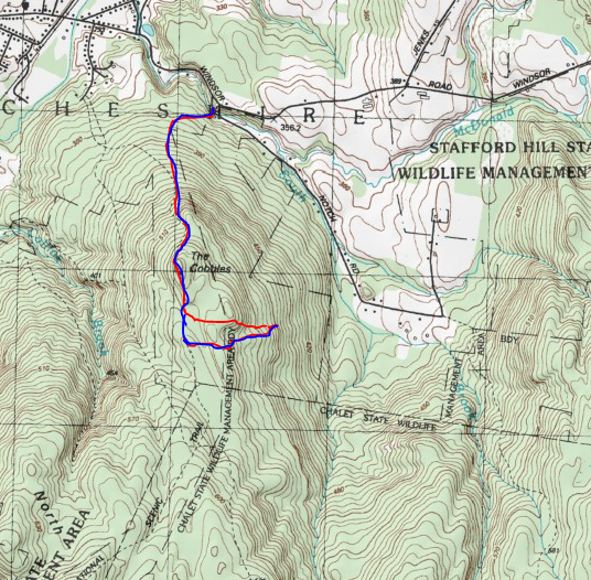
Decided to do a quick little hike to Cheshire Cobbles in the Berkshires after work this afternoon...with a little twist added in. That twist was to finally find a large rock slide that sits less than half a mile off trail to the SE of the Cobbles. First things first, I parked in the unmarked parking area off of Notch Road which provides access to the Chalet WMA. Elevation here is roughly 1100 feet, where an unmarked but obvious foot path heads south into a shaded hemlock forest.
There are a series of unmarked trails that criss-cross these woods as it climbs, but the main trail is pretty obvious and eventually meets up with the Appalachian Trail. At this point, you have gained a few hundred feet and the woods have transitioned to hardwoods.
A final steep push up, brings you to the spot known as Cheshire Cobbles. It is an large area of open rocks that offers up expansive west facing views. The Greylock Range looms impressively above the village of Cheshire to the NW from here.
To the SW, the view encompasses much of Cheshire Lake.
A short distant beyond the viewpoint along the AT, at the actual top of "The Cobbles", I found this Witness Post Survey Marker. Has certainly seen better days, however.
Continued on a short ways beyond the high spot before leaving the trail, beginning a bushwhack east through the woods. The woods were mostly open, with just some annoying low growth and witch hobble to slow me down. After roughly 4/10 of a mile and a little bit of up and down I found the elusive slide I had been searching for. The views east are quite nice, but I clearly wasn't the first to be here. Lawn chairs and a fire pit told me that locals are probably well aware of it. The Hoosac Range rises off in the distance to the NE.
The sheltered valley of Notch Road sits below to the east with the nearby hills of the Chalet WMA just above.
To the SE, across the valley I spotted more open rock on the next ridge over. If I had more time I would've loved to explore that area, but for now will have to chalk it up to a future trip.
After enjoying the views from the rock slide, I headed back to the trail and easily descended back the way I had come. Just prior to arriving at the car, I dropped down into the deep gorge cut out by McDonald Brook, where a pretty little area of cascades tumbles into a small pool. This made the perfect spot to rinse up and get some of the sweat off.
Hiked about 3.3 miles RT with just under 1000 feet of total ascent.
Today's Route below. Red=Ascent(in) Blue=Descent(return)


No comments:
Post a Comment