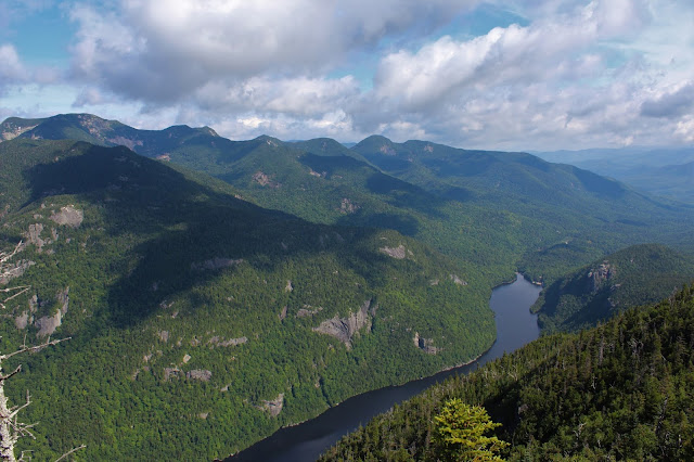
Decided to head north up to the Adirondacks again today to knock off two more High Peaks with my buddies Joel and Mark. Today's goal was to hit 4057 foot Mount Colvin and 3960 foot Blake Peak from Lake Road at the Ausable Club in Saint Hubert's. The forecast was for high temps and humidity and a chance for storms, so we brought plenty of fluids and hit the trail 6;45 AM. Elevation at the parking area is 1270 feet.
The walk past the golf course and resort is pretty nice, with a spectacular mountain setting.
The road walk is pretty boring, but it gets you where you need to get fairly quickly and uneventfully. The best part of Lake Road, in my opinion, is the babbling water and multiple cascades and falls on Gill Brook, which is your companion for much of this part of the hike.
We stayed on Lake Road to the Gill Brook Cut Off and then headed up towards Elk Pass. At a trail junction with Nippletop(left) and Colvin(right) at 3200 feet, we stopped to grab a snack and made friends with the local chipmunk population.
We headed right from the junction and almost immediately began a rocky climb up towards Colvin.
The climb up Colvin is pretty straightforward with only a couple of tricky spots, which are easily tackled.
Arriving at the summit of Mount Colvin, elevation 4057 feet. There is no summit sign, but did find some kind of benchmark at the top.
The views from Colvin's summit are nothing short of spectacular. The view north takes in Lower Ausable Lake and Indian Head(left), just over Colvin's ridgeline. Off in the distance are Giant and Rocky Peak Ridge with Noonmark in front of it.
The views of the entire Great Range from here are second to none. It is literally sprawled out before you from its north end to the south end, with impressive amounts of open rock all around. Directly in front of you is Sawteeth(foreground), with Basin, Saddleback and Gothics just beyond.
Amazing views of Sawteeth directly above Lower Ausable Lake, with Armstrong, Upper and Lower Wolfjaws to the north.
Zoom view towards Lower Ausable Lake and Indian Head, as well as Fish Hawk Cliffs. The north end of the Great Range is in the distant left.
Just a couple hundred feet beyond the summit is another open ledge, this one with incredible south facing views. Our next destination, Blake Peak, can be seen rising up to the south with Upper Ausable Lake down below. The far south end of the Great Range can also be seen, as well as Allen Mountain.
Looking back up as I climbed down the ladder.
After over 600 feet of descent, we bottomed out at just over 3425 feet in the saddle between the peaks and took a couple minutes to rest. The humidity was real high and we knew hydration and resting were essential. Moments later, we began our climb up Blake.
While Blake gets a bad rap and is known for its lack of views, I found the steep scramble up the mountain fun, and sprinkled in with fine views back towards the Great Range like this.
After a short but steep ascent, we hit the wooded, barely noticeable top. The 3960 foot summit of Blake is pretty boring when compared to Colvin's fireworks, so we didn't linger long.
After hitting Blake's nondescript summit, we quickly turned back, retracing our steps back down towards Colvin. Just prior to the steep drop into the col, I caught this neat shot of Colvin(left) and Nippletop's ridge(right).
The descent was steep but we took our time and all went well. Just as quickly as we hit the saddle, we the ascent commenced with a steep climb back up Colvin.
Back on Colvin's summit, we stopped to grab a quick bite and take a few more pics. The afternoon lighting was much better to enjoy the view east towards Nippletop. Nippletop's slide looks incredibly steep and impressive.
After a few minutes, we decided to head back down, descending steeply off Colvin.
The descent, as always in the High Peaks, can be the most challenging part of the hike. Luckily it went off without a hitch and we were making great time, contemplating whether or not to hike up to Indian Head for its amazing views. Well... Mother Nature decided that one for us. As we got down below 2500 feet, the woods grew eerily dark and ominous. Moments later it began to rain. Then it got harder..and harder. A deluge with thunder rumbling all around. Try as we may to keep dry, we were absolutely drenched. No Indian Head today. Instead we took the Cut-Off trail back to Lake Road and sloshed our way back. Soon after hitting the road, the skies cleared and the sun reemerged.
A quiet and benign walk back on Lake Road brought us back to the car. Just under 14 miles RT with 4310 feet of total ascent. 26/46


The Great Range never ceases to impress! The only comparable range in my opinion is the Presidential Range in NH. Awesome photos!
ReplyDeleteThanks Ned!! Always appreciate the kind words. Those views of the Great Range are killer!!
DeleteFor your interest, the photo showing the benchmark on top of Mt Colvin was actually installed by Verplanck Colvin himself and or his surveying team around or shortly after the year 1872. This was the style benchmark they used on many of the Adirondack peaks they surveyed.
ReplyDeleteThank you for that tidbit..I actually love that type of info! Much appreciated!
Delete