Search This Blog

Saturday, July 30, 2022

Unnamed Hill North of Moon Mountain(Pack Demonstration Forest-Adirondacks)

Did a short hike to a very obscure little peak just east of the Hudson River in Warrensburg this afternoon on what proved to be a gorgeous day.  If you are hard pressed for time but still looking for something with a little bang for the buck and away from the crowds, this peak has much to offer!  I parked in unmarked large pull off on the east shoulder of CR-40(Elevation 705 feet) and headed SE into the woods following a good woods road just beyond a gate that is mostly hidden by summer vegetation.  

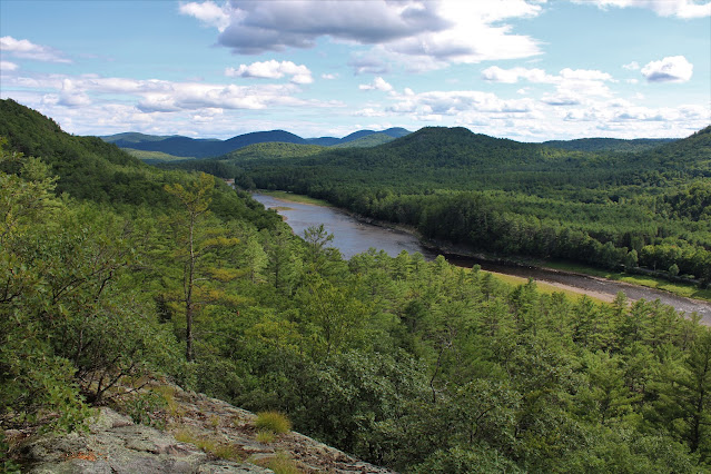
The woods road climbs steadily SE, but never steeply, becoming a bit less viable the further up.  I did a bit of exploring south before returning north towards the unnamed hill I wanted to hit.  There are some real nice ledges on this peak facing west, with one in particular providing stellar views.  This is a look south down the Hudson River from the open ledge.
From the same ledge, looking across the Hudson to the west stands Potter Mountain.
After checking out the views as well as other west facing ledges(no other good views I could find though), I bushwhacked over to the 990 foot true summit, which was fully wooded.
Wandered the woods a bit before making my way back down the woods road to the car.  Before leaving, I crossed CR-40 to get an up close view of the Hudson and it was beautiful as always.

A nice and easy 1.8 miles RT, with about 300 feet of ascent.

Map Below.   Red P=Parking  Red X=Unnamed Summit


Wednesday, July 27, 2022

Garnet Hill(Town of Peru, Berkshires)

Visited Peru in the hilltowns of the eastern Berkshires to hike 2185 foot Garnet Hill, a small peak with a little bit of history tucked into it.  The humidity was fairly low making for a beautiful summer day to do a little exploring after work.  To get started, I parked in a small pull off along Curtin Road, a rough dirt road, far away from civilization(Elevation 1790 feet)in the Peru State Forest.

A Mass DCR sign for Garnet Hill marks the start of the hike, heading west on an abandoned old CCC road. The hike along the road is quite rocky, but still easy, very gradually gaining elevation along the way.

After nearly 3/4 of a mile, a foot path/ ATV trail leaves the road and heads south, marked with occasional American flags as trail markers.

Just a bit over 1/3 of a mile from the road, I arrived at a Memorial Site.  This marked the spot of a horrific 1942 plane crash, involving 19 US Air Force Paratroopers, claiming the lives of 16 of these soldiers. The men were returning from a training mission during the height of World War 2.

Plaque honoring the fallen.

From the Memorial site, I retraced my steps back to the old CCC road and then continued my slow ascent up to the summit.  The road ends in a meadow like clearing just below the true summit, complete with a fire pit and a view.

The summit views aren't great, but at nearly 2200 feet, the view east is still nice.

I attempted to get a better view, but unfortunately it didn't help.

I explored the area around the summit, and it is filled with the most abundant areas of fern glades that I may have ever seen.  Nestled in amongst the waist high sea of ferns were impressive old stone walls as well!

I eventually wandered up to the true 2185 foot summit, that sits about 100 yards off the old road and itself sits in a small clearing.  Not really much to see though.

A very easy bushwhack brought me over to the CCC road, which I hiked all the way back down to the car.  An interesting 3.5 miles RT, with over 400 feet of ascent, and didn't see another person.  Did, however, see many annoying bugs that kept me company. 

Map Below.  Red=Old Road/ ATV Trail   Blue=Foot Trail/ ATV tracks to Memorial  Black X=Memorial


Friday, July 22, 2022

Robert Ingalls Preserve(Town of Stephentown, Rensselaer County)

Headed out for a short walk at the Rensselaer Land Trust's Robert Ingalls Preserve this evening following a brief downpour on yet another hot and sultry summer day.  The rain temporarily cooled things off to a somewhat tolerable level, so I tried to take advantage of that small window. 

Conditions have been quite dry all summer, and although Black Brook was low it did have ample water to soak my feet in.
Evening sunshine coming through the tree canopy.
I wandered the various trails at the Preserve, but was quickly noticing an increase in humidity as I made my way through the woods.
Sally's Rest-A new addition since my last visit here-is a bench along the Ridge Trail overlooking the wooded ravine of Black Brook. 
Covered a nice and easy 1.5 miles RT, and worked up a good sweat along the way.
 

Tuesday, July 19, 2022

Blueberry Mountain(High Peaks Wilderness-Adirondacks)

Did a short hike up Blueberry Mountain in the heart of the High Peaks region on this sultry, steamy summer day.  Blueberry Mountain may be short in stature nestled among much higher peaks, but it is quite a steep trail with good views on top to boot.  I parked at Marcy Airfield(Elevation 985 feet)and much to my surprise, only saw two other cars there when I arrived. 

The trail is quite rugged and steep, and I was working up a really good sweat-gaining 2000 feet in just over 2 miles. I was rewarded with many good views along the way though!  Looking down into Keene Valley with Giant Mountain towering above.

Porter Mountain's neighboring ridgeline.

Views towards the Great Range.


Southeast views ranging from Giant(left) to Dix(far right).

There are great views from numerous vantage points including this look north towards Keene.
NW views towards Pitchoff's long ridge.
Although the views were enjoyable, it was quite uncomfortable in the steamy mid day heat, so I descended hastily to try to beat the worst of the blazing sun. 
A tough little hike, but very rewarding.  About 4.8 miles RT, with over 2000 feet of ascent and only saw one other hiker all day!!  Stay hydrated my friends.


Saturday, July 16, 2022

Long Path-Joslyn Road to Doppler Radar(Town of Berne, Albany County)

Did a short evening walk along a quiet stretch of the Long Path in the hilltowns of rural Albany County today.  Parked along Joslyn School Road in East Berne near an old, abandoned farmhouse and headed out, crossing through open fields on private property.(Elevation 1480 feet)

On the far side of the field, the trail enters the woods continuing through private property and passing by old stone walls.

 After a little more than half a mile, the trail jogs west, where it begins a more gradual climb.


The trail utilizes various woods roads as it meanders its way up through a mostly hardwood forest.

Arriving at the Doppler Radar Station at the end of Woodstock Road.  This was also the high point of the hike at 1830 feet elevation.

Turned back from the Doppler Radar station and retraced my steps back to the car for a total of 3.2 miles RT, with 350 feet of ascent, and didn't see anyone else the entire time.


Thursday, July 14, 2022

Birch Hill Loop(Town of Williamstown, Berkshires)

Did an after work hike in the northern Berkshires today, exploring the slopes of Birch Hill, a foothill just east of the Taconic Ridge in Williamstown.  Parked on the shoulder of Petersburg Road(Elevation 760 feet) where there is room for one or two cars and immediately dropped down to an easy rock hop crossing of Birch Hill Brook.

The Buxton Ravine Trail is a beautiful climb up the northeast slopes of Birch Hill through the Hunter Property, a 190 acre conservation area owned by the town of Williamstown.
The Buxton Ravine Trail climbs nearly 600 feet in about 8/10 of a mile before meeting up with the Hunter Family Loop and then Bob's Ski Loop, both part of the Taconic Trail State Park.  Once up high, the ridge walk is quite pleasant, passing through several expansive areas of ferns.
The 1611 foot true summit sits about 50 yards off trail and is fully wooded.
From the summit, the trail continues west, dropping slightly on a wide ski trail.
At the west end of Bob's Ski Loop, the trail emerges in an enormous meadow.  From this open vantage point, the Taconic Ridge towers almost directly above to the west.
Looking SW from the top of the open field towards Berlin Mountain's ridge.
After the brief hike through open fields, I headed back into the woods on the Sarah Tenney Trail, heading east on the slopes just south of Birch Hill's summit.  Eventually met back up with the Hunter Family Trail on the east edge of Birch Hill's ridge, then looping back towards the Buxton Ravine Trail. 
Descended via the Buxton Ravine Trail back to the car, for a total of 4.4 miles RT and 1000 feet of climbing.

Map below.  Blue Lines=Route Taken


Saturday, July 9, 2022

Simonds Hill & Cleveland Hill(Town of Pawlet, Vermont)

Just north of Manchester in the middle of nowhere in Vermont sits a small group of peaks known as the North Pawlet Hills that are all accessible to the public-and all have a little something to offer!  The only trailed peak out of the bunch is the highly popular Haystack Mountain, but a couple years ago I had bushwhacked up to its northern neighbors, Lincoln Hill, Bald Hill and Middle Mountain, and found awesome views.  The two remaining peaks that I haven't hiked, Simonds Hill and Cleveland Hill were the two I'd be climbing today.  I parked at the end of rough Rees Road in a large field(Elevation 640 feet), the NW entrance to the North Pawlet Hills.  I hiked the continuation of the road uphill, beyond the Nature Conservancy signage and into the woods.

The road begins in pretty decent shape, steadily climbing past a small cabin, but deteriorates fairly quickly into a rough woods road and even just a foot path.


I climbed the road heading generally east, then south on a lesser woods road, before simply bushwhacking up towards Simonds Hill.  The summit ridge was actually very nice and open, and easy walking through sedge grass right up to the 1210 foot summit.

I headed over to the south facing slopes, which were also fairly open and steep, offering up decent views towards Cleveland Hill, my next destination.

From the same clearing, enjoyed this view towards Haystack Mountain, towering over 700 feet higher to the SE.


From my drive in, I thought I had seen some ledges on Simonds, so I descended west to an area just below 1000 feet and found what I was looking for.  A long, wide open area of west facing ledges stretching out over the Route 30 valley below.

To the north, the view stretches as far as Lake Saint Catherine, with the eastern Adirondacks on the horizon.

SW views.

After enjoying the great views on Simonds, I headed over towards Cleveland Hill, contouring along Simonds steep south slopes.

I utilized a combination of bushwhacking and some rough woods roads to make my way over to Cleveland Hill's 1384 foot summit, which was wooded but fairly open.

I explored the southern slopes just off the summit and found a nice framed view south over the Pawlet countryside.

The south slopes were wide open and great for exploring.
From a steep area of ledges, I found a killer up close view of Haystack Mountain!

Just below the ledge views towards Haystack, I found another view south towards Pawlet over Haystack's long south ridge.  With the leaves off, these ledges would have incredible views!!

After enjoying all of the views, I made my way back around Cleveland and then Simonds, eventually descending a rough old woods road that I found to be called Oak Ridge Road. 

Hiked a touch over 5 miles RT, with 1100 feet of combined ascent for the day and of course didn't see another soul.  In addition to that, there were no bugs and no humidity, making for a picture perfect summer day!  

Map below.  Red P=Parking   Blue X's=Summit's hit today