Even on a Tuesday, there were 4 other cars there when I arrived, mostly attributed to the gorgeous weather. I quickly geared up and ventured out, quickly passing a beaver pond.
The trail is pretty mellow for the first 2 miles, following an old jeep road and gaining only about 450 feet. After about 1.1 miles, a footbridge crosses unnamed brook.
A bit later, crossing a muddy stream.
Another small brook crossing.
After 2 pretty easy miles I arrived at a bend in the trail and a DEC sign stating only 1 mile to go.
The last mile is a steady, muddy climb, ascending nearly 1200 feet.
The climb was tough due to the amount of mud but manageable. Just below the summit, I came to a large wooden helipad deck.
Continuing about 100 yards beyond the helipad and back on the main trail, I quickly arrived at the fire tower and cabin.
The cabin is open and looks like it has been used recently, judging by the inside. I believe you can stay here on a first come first serve basis.
The 92 foot fire tower at the summit is the tallest in all of the Adirondacks.
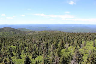
I climbed up the fire tower while getting blasted by a cold wind. Even though it was in the low 70s, it certainly felt cool. The views were outstanding in all directions though.
Looking out beyond the evergreens to the northwest.
A fantastic view to the northeast.
Many distant peaks are visible to the north.
Looking west towards the Fulton Chain of Lakes.
A great look down towards Wakely Pond and a beaver pond near the trail up the mountain.
I enjoyed the scenic vista from the firetower for a bit, but decided not to linger too long because of the strong winds. Here is a view of my return along the muddy trail.
The steep, wet descent.Hiked back the remaining 3 miles, which went by uneventfully for a total of 6 miles RT.
After getting back to the car, I took my time on winding, scenic Cedar River Road. I stopped off along the way to visit Sprague Pond, which can be reached via .3 mile trail. A couple of small unmarked pull offs make for easy parking. The trail is pretty straightforward and leads to a picturesque spot along the pond's shores. The rocks in the foreground make for a nice photo.
My last stop for the day was a quiet pull off along Cedar River Road, with access to the Cedar River. The brilliant late afternoon sunshine lit up the river nicely. Although there are many homes along this area, the river certainly has a wild feel to it here.


No comments:
Post a Comment