Decided to head east into the rugged highlands of the northern Berkshires today to re-hike 1775 foot Negus Mountain, a small but memorable peak I had climbed a few years ago. A mix of clouds and fleeting sun, as well as temps near 60 degrees greeted me as I arrived at the unmarked parking area along Zoar Road(Elevation 654 feet), just east of a bridge crossing over the Deerfield River. From the parking area, I entered the woods for a few yards to a railroad crossing and then picked up the marked trail, heading northeast.
The ascent NE begins almost immediately and becomes increasingly steeper through open hardwoods.. Fallen, slick leaves made footing a bit difficult on the steeper stretches but taking my time I had no issues. Within just a few minutes, the woods give way to open grassy areas mixed with bare rock.
An early peek at the false summit cone poking out high above.
South view towards Todd Mountain in the Mohawk Trail State Forest.
The trail is quite steep and very exposed meaning that good views can be enjoyed almost throughout. This was a nice view SE a few steps off trail towards Berkshire East Ski Area.
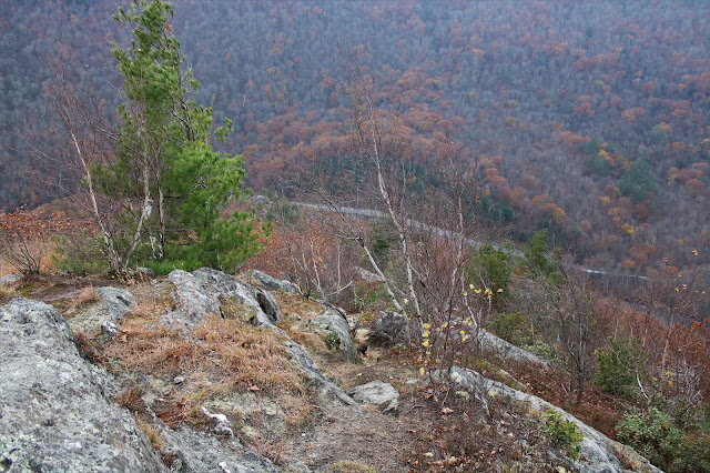
As the elevation increases, the views get better as well! The view NW is especially nice, taking in the contour of the steep, wooded slopes above the Deerfield River and some kind of quarrying operation.
There are literally views around every bend, with a strong breeze now picking up on the exposed ridge, just before the trail dips into a wooded area at about 1700 feet.
After climbing up and over a small, almost unnoticeable bump, the character of the trail changes dramatically, now passing through a mix of mountain laurel, white birch and beech.
After a few minutes of fairly level hiking, a final short, steep push brings you to a fire pit and overlook just below the summit. The view west is somewhat obscured but still nice. From here, it was easy to see the clouds beginning to quickly move in.
The wooded 1775 foot summit sits about 1/10 of a mile off trail to the east of the overlook. A small cairn marks the high spot.
After hitting the top, I headed back down, stopping briefly once again at the incredible NW view point. Upper Reservoir Bear Swamp is the body of water to the right, with the Deerfield River way down in the deep valley. Whitcomb Hill is the high ridge in the distance.
Although the slopes are steep, east facing views are much harder to find due to more tree growth. With a little bit of exploring off trail, I was able to find one nicely framed view SE over the Deerfield River into the town of Charlemont.
Negus Mountain is a unique hike in that the descent is much harder than the ascent due to the incredible exposure and wide open terrain. This is literally the view down to the Deerfield River and my waiting car nearly 1000 feet below as I begin my drop.
A bit further down on the descent, being extra careful to steer clear of fallen leaves which can be quite slick.
Took my time on the descent, arriving back at the car safe and sound. Hiked about 3.3 miles RT, with 1200 feet of ascent and didn't see another person all day. Ticks, however, remain an annoying issue as I picked several more off of my pants again today.
Map below.
The drive home took me by the nearby Tunnel Road bridge which spans the Deerfield River, and is highly scenic. Even if you aren't able to hike this area, the drive alone is well worth the effort.


I have driven by this peak several times but have never hiked it thanks for posting, I will try next year.
ReplyDeleteI highly recommend it...it's a very fun climb with killer views. Be extra careful if doing it in winter!
Deleteit's a steep but fun climb
ReplyDeleteThis comment has been removed by the author.
DeleteOne of my favorite "short" hikes
Delete