Headed up into the Lake George region today to check out 1760 foot Bloomer Mountain, a trail-less peak that sits just north of the Tongue Range. I parked at the trailhead for Deer Leap and the northern section of the Tongue Range from Route 9N(Elevation 1065 feet) and then headed north into the woods to begin my bushwhack. The woods were pretty open and I quickly came to a couple of small stream crossings, which I easily rock hopped.


After a steep push up, the woods opened up into a small, level clearing with the first good views of the day. Black Mountain was easily seen to the east, across Lake George.


A bit further along the eastern knob, I found this nice view SW with Bloomer's true summit on the right.

Continued west on the ridge towards the true summit, which was straightforward and easy, with filtered views throughout.


From a perch just below 1500 feet, I found a really nice view SW over an unnamed wetland and to the distant southern Adks, with Gore Mountain's ski slopes on the distant horizon(right).


From the western edge of the summit area, I headed back east along the ridge to a saddle between the peaks, where I was safely able to descend the steep south slopes back down off the mountain. From there it was a nice and easy hike back to the car for a total of 3.2 miles RT and 1050 feet of combined ascent.
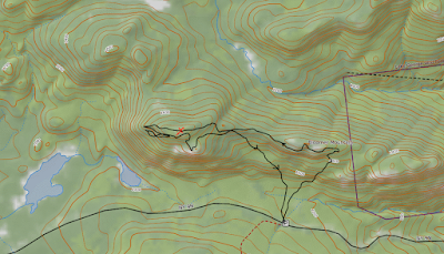
Map below, with rough route in black. Red X=True Summit
I've seen those ledges from the Deer Leap and Brown Mt. trails and always wondered what it was like to roam around up there. Very nice! Great views thanks for sharing.
ReplyDeleteShort but sweet! So many nice little off-trail peaks around Lake George!
ReplyDelete