Headed south today to do a little exploration of Candlewood Hill's summit ridge in the Clarence Fahnestock State Park, located just west of the Taconic State Parkway and near the Dutchess and Putnam County lines. While the true summit only rises to a modest 984 feet elevation, Candlewood Hill actually has three separate summit bumps, running along a long north-south ridge. There are a couple of different ways to access this trail, but either way is off the beaten path so you have a pretty good chance of solitude on this hike. I parked west of the summit at the very end of the driveable section of Bell Hollow Road, just past the last house and off to the shoulder(Elevation 460 feet).
To begin the hike, I headed north along the rock filled, deteriorating Bell Hollow Road for just over half a mile, slowly ascending nearly the entire way.
Bell Hollow Road eventually meets up with driveable Sunken Mine Road, having gained over 250 feet from the beginning of the hike. Although it is driveable(not maintained in winter) it is a very low traffic, rough road, making for pleasant hiking.
After less than 3/10 of a mile on Sunken Mine Road, I picked up the red blazed Candlewood Hill Trail, which is a foot trail that enters the woods, climbing 250 feet in just over a quarter of a mile.
Nearing the summit of Candlewood Hill, the views quickly begin to open up all around you. North facing views of the surrounding hills are the first to greet you-but they are just the tip of the iceberg.
Candlewood's summit is a real joy to explore, with many good views from multiple open patches of rock. The sheer drop off on the west facing ledges make for some incredible views down into Bell Hollow.
The best views of all are to the south from a large area of open rock. This sweeping view takes in the long southern ridge of Candlewood, as well as a corner of Oscawana Lake. To the right of the ridge is the deep valley carved out by Canopus Creek.
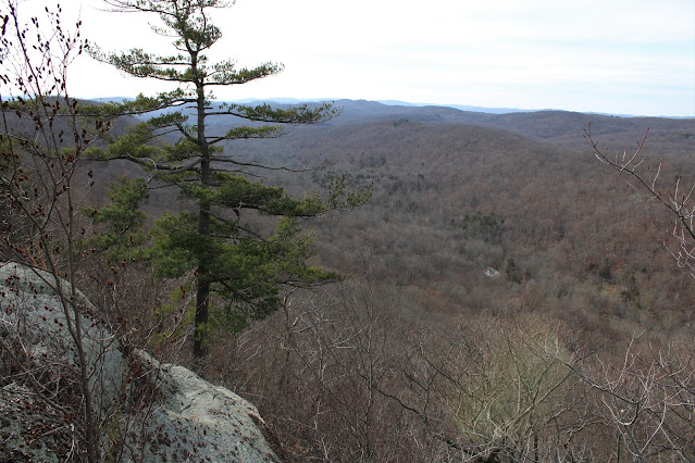
West views across Bell Hollow towards the next ridge, where the Appalachian Trail actually runs.
After enjoying the many wonderful views atop Candlewood, I continued on, dropping south down the rock filled slopes. A large bee hive caught my attention directly above the trail, making me thankful that it is mid December and not mid Summer.
The red blazes begin to drop more steadily until coming to a junction with a yellow marked trail. The red trail simply drops back down to Bell Hollow Road, completing a loop hike for those who may be pressed for time. I decided to take a left onto the yellow blazed trail, which soon climbs back up towards the next summit bump along the ridge.
This summit bump is a bit lower than the first at only 925 feet, but offers up just as many awesome views. From just below the top, I enjoyed this view east out over Oscawana Lake.
To the west, an expansive open rock ledge provides a great view with the Hudson Highlands even visible on the distant horizon.
Far reaching views to the south/ southwest!
From a spot a bit further down the ridge, below the second summit, I found this sweet view towards the third summit along the ridge.
The approach to the third summit bump begins to see a change in the character of the surroundings, with many more stone walls and old hunter's tree stands.
Stone art along the trail.
The third summit bump is even lower than the first two, at only 843 feet. Unfortunately there are no great views from this bump either, although the woods are very nice and open with screened views all around.
Continued south along the skinny ridge to a fourth, lower summit, where the trail begins to descend to the east. Turned back there, retracing my steps north up and over the second and third summits and eventually to the red blazes once again. Once on the red blazed trail, it was a short and easy drop down to my waiting car on Bell Hollow Road.
Arrived back at the car, barely beating the incoming rain. A very pleasant, quiet 5.5 miles RT with 1800 feet of combined ascent.
Map below. Blue P=Parking on shoulder of road Red X's=Three Summits of Candlewood Hill


Wow, that's almost downstate! I always assume it will be crowded down there but not really, if you time it right. Looks like a great hike!
ReplyDeleteHi Ned! Yeah, there are some real good hikes down in the Hudson Valley.......aka..."downstate", you just work a little harder to find for some solitude on the trails.
Delete